
Highest point Llullaillaco | ||
 | ||
Mountains Llullaillaco, Tipas, Nevado de Cachi, Del Veladero, Reclus | ||
Puna de atacama
The Puna de Atacama or Atacama Plateau is an arid high plateau, in the Andes of northern Chile (15%) and Argentina (85%). Geomorphologist Walther Penck based his Grossfalt landform association on Puna de Atacama.
Contents
Puna de atacama catamarca argentina
Geography
The plateau's elevation averages 4,500 metres (14,800 ft) above sea level, and it spans an area of 180,000 square kilometres (69,000 sq mi).
In Argentina, Puna's territory is extended in the provinces of Salta, Jujuy and western Catamarca. In Chile, it is included in the regions of Antofagasta and north-eastern Atacama.
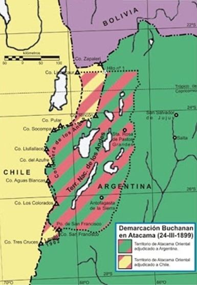
International borders
Before the War of the Pacific (1879–1883), the region belonged to Bolivia. In 1898 it was ceded to Argentina in exchange for recognition of Tarija as part of Bolivia. Chile, which had annexed the Litoral Province from Bolivia, declared the exchange illegal. The border was defined in 1899 after the Puna de Atacama dispute. Of the 75,000 km2 in dispute 64,000 (85%) were awarded to Argentina and 11,000 (15%) to Chile.