
Mountain type Stratovolcano Elevation 5,430 m Parent range Andes | Last eruption Unknown Mountain range Andes | |
 | ||
Similar Cochiquito Volcanic Group, Caichinque, Irruputuncu, Arintica, Cerro del Azufre | ||
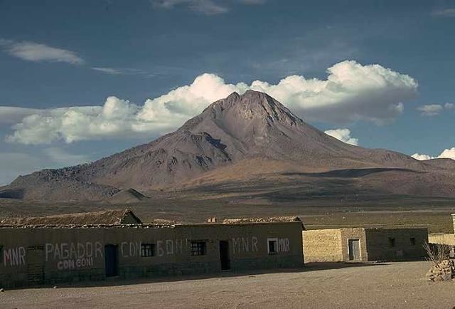
Tata Sabaya is a stratovolcano in Bolivia. It is located at the northern end of the Salar de Coipasa, which lies in the Altiplano. It also lies at eastern end of a line of volcanoes starting with Isluga in the west, and continuing with Cabaray. Its last eruption date is unknown, but it is assigned to the Holocene due to the youthful appearance of the mountain.
Contents
Map of Tata Sabaya, Bolivia
Geology
The volcano is a symmetrical unglaciated cone that rises 1700m above the surrounding terrain, and part of an east-west chain of two volcanoes with Cerro Sacsani. The volcano formed as a pyroclastic shield possibly surrounding a central lava dome that was subsequently buried by an andesitic cone. The volcano is constructed on Cenozoic ignimbrites; some granitic terrain is exposed on the northern side of the volcano.
Petrology
The magmas forming the volcano became more silicic over time. Phenocrysts are dominated by plagioclase; in the latter stages of activity biotite dominates over pyroxene. The magma features suggest that the magmas underwent large scale mixing.
Debris avalanche
The southern flank of the volcano underwent a collapse, forming a 300 km2 large landslide deposit in the Salar de Coipasa. The deposit has an inverted T shape and an approximate volume of 6 km3, containing various kinds of hummocks. The deposits are little hydrothermally altered but contain prismatically joined blocks, suggesting that the collapse was precipitated by seismic and magmatic activity and not by hydrothermal weakening of the rock. The avalanche deposit contains Toreva blocks and is covered by carbonate deposits, suggesting that it entered the salar when it was still a lake. Radiocarbon analysis of the avalanche deposits suggest that the edifice collapse occurred between 6000 and 16000 years ago, 12000 being suggested by the height of the carbonate deposits that match the Tauca stage of Coipasa lake evolution.
Activity
A small active fumarole was observed on the summit of Tata Sabaya in 1995.