Province Province of Pordenone | Elevation 1,921 m Mountain range Venetian Prealps | |
 | ||
Similar Col Nudo, Monte Duranno, Cima dei Preti, Campanile di Val Montanaia, Monte Serva | ||
Animazione digitale della frana del monte toc vajont
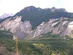
Monte Toc, nicknamed the walking mountain by locals due to its tendency to landslide, is a mountain on the border between Veneto and Friuli-Venezia Giulia in Northern Italy best known for the Vajont Dam, which was built at the mountain's base in 1960.
Contents
- Animazione digitale della frana del monte toc vajont
- Map of Monte Toc 33080 Erto e Casso Province of Pordenone Italy
- Panoramica del monte toc la frana del vajont
- References
Map of Monte Toc, 33080 Erto e Casso, Province of Pordenone, Italy
On October 9, 1963, 260 million cubic metres of rock slid down the side of Mount Toc and plunged into the reservoir created by the Vajont Dam sending a wave of water 250 metres high over the dam wall and destroying the town of Longarone and its suburbs. 1,918 people were killed, 1,450 of whom were in Longarone.
Panoramica del monte toc la frana del vajont
References
Monte Toc Wikipedia(Text) CC BY-SA
