
 | ||
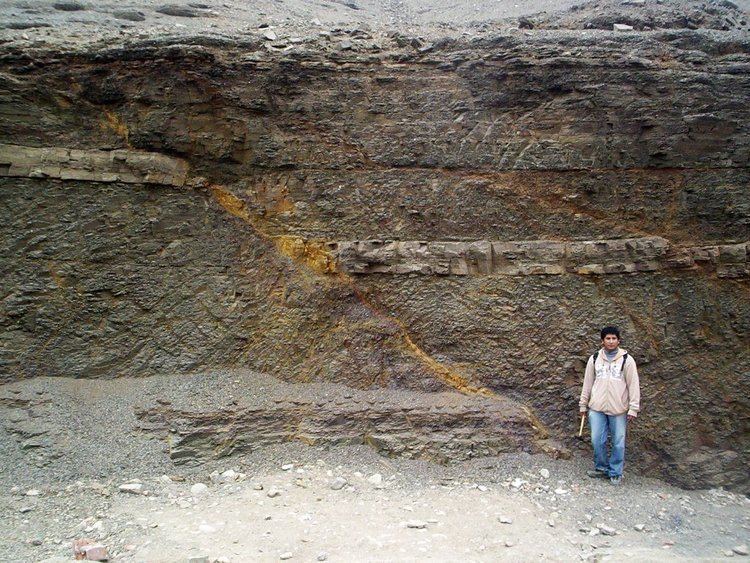
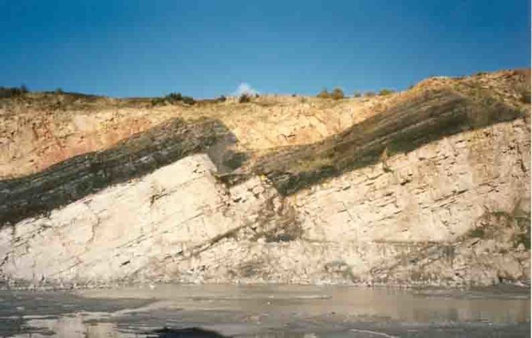
In geology, a fault is a planar fracture or discontinuity in a volume of rock, across which there has been significant displacement as a result of rock-mass movement. Large faults within the Earth's crust result from the action of plate tectonic forces, with the largest forming the boundaries between the plates, such as subduction zones or transform faults. Energy release associated with rapid movement on active faults is the cause of most earthquakes.
Contents
- Classification of Faults
- Mechanisms of faulting
- Slip heave throw
- Fault types
- Strike slip faults
- Dip slip faults
- Oblique slip faults
- Listric fault
- Ring fault
- Synthetic and antithetic faults
- Fault rock
- Impacts on structures and people
- References
A fault plane is the plane that represents the fracture surface of a fault. A fault trace or fault line is the intersection of a fault plane with the ground surface. A fault trace is also the line commonly plotted on geologic maps to represent a fault.
Since faults do not usually consist of a single, clean fracture, geologists use the term fault zone when referring to the zone of complex deformation associated with the fault plane.
The two sides of a non-vertical fault are known as the hanging wall and footwall. By definition, the hanging wall occurs above the fault plane and the footwall occurs below the fault. This terminology comes from mining: when working a tabular ore body, the miner stood with the footwall under his feet and with the hanging wall above him.
Classification of Faults
Mechanisms of faulting
Because of friction and the rigidity of rocks, they cannot glide or flow past each other easily, and occasionally all movement stops. When this happens, Stress builds up in rocks and when it reaches a level that exceeds the strain threshold, the accumulated potential energy is dissipated by the release of strain, which is focused into a plane along which relative motion is accommodated — the fault.
Strain occurs accumulatively or instantaneously, depending on the rheology of the rock; the ductile lower crust and mantle accumulates deformation gradually via shearing, whereas the brittle upper crust reacts by fracture – instantaneous stress release – to cause motion along the fault. A fault in ductile rocks can also release instantaneously when the strain rate is too great. The energy released by instantaneous strain-release causes earthquakes, a common phenomenon along transform boundaries.
Slip, heave, throw
Slip is defined as the relative movement of geological features present on either side of a fault plane, and is a displacement vector. A fault's sense of slip is defined as the relative motion of the rock on each side of the fault with respect to the other side. In measuring the horizontal or vertical separation, the throw of the fault is the vertical component of the dip separation and the heave of the fault is the horizontal component, as in "throw up and heave out".
The vector of slip can be qualitatively assessed by studying any drag folding of strata, which may be visible on either side of the fault; the direction and magnitude of heave and throw can be measured only by finding common intersection points on either side of the fault (called a piercing point). In practice, it is usually only possible to find the slip direction of faults, and an approximation of the heave and throw vector.
Fault types
Based on direction of slip, faults can be generally categorized as:
Strike-slip faults
The fault surface is usually near vertical and the footwall moves either left or right or laterally with very little vertical motion. Strike-slip faults with left-lateral motion are also known as sinistral faults. Those with right-lateral motion are also known as dextral faults. Each is defined by the direction of movement of the ground on the opposite side of the fault from an observer.
A special class of strike-slip faults is the transform fault, where such faults form a plate boundary. These are found related to offsets in spreading centers, such as mid-ocean ridges, and less commonly within continental lithosphere, such as the Dead Sea Transform in the Middle East, or the Alpine Fault, New Zealand. Transform faults are also referred to as conservative plate boundaries, as lithosphere is neither created nor destroyed.
Dip-slip faults
Dip-slip faults can occur either as "reverse" or as "normal" faults. A normal fault occurs when the crust is extended. Alternatively such a fault can be called an extensional fault. The hanging wall moves downward, relative to the footwall. A downthrown block between two normal faults dipping towards each other is called a graben. An upthrown block between two normal faults dipping away from each other is called a horst. Low-angle normal faults with regional tectonic significance may be designated detachment faults.
A reverse fault is the opposite of a normal fault—the hanging wall moves up relative to the footwall. Reverse faults indicate compressive shortening of the crust. The dip of a reverse fault is relatively steep, greater than 45°.
A thrust fault has the same sense of motion as a reverse fault, but with the dip of the fault plane at less than 45°. thrust faults typically form ramps, flats and fault-bend (hanging wall and foot wall) folds.
Flat segments of thrust fault planes are known as flats, and inclined sections of the thrust are known as ramps. Typically, thrust faults move within formations by forming flats, and climb up section with ramps.
Fault-bend folds are formed by movement of the hanging wall over a non-planar fault surface and are found associated with both extensional and thrust faults.
Faults may be reactivated at a later time with the movement in the opposite direction to the original movement (fault inversion). A normal fault may therefore become a reverse fault and vice versa.
Thrust faults form nappes and klippen in the large thrust belts. Subduction zones are a special class of thrusts that form the largest faults on Earth and give rise to the largest earthquakes.
Oblique-slip faults
A fault which has a component of dip-slip and a component of strike-slip is termed an oblique-slip fault. Nearly all faults will have some component of both dip-slip and strike-slip, so defining a fault as oblique requires both dip and strike components to be measurable and significant. Some oblique faults occur within transtensional and transpressional regimes, others occur where the direction of extension or shortening changes during the deformation but the earlier formed faults remain active.
The hade angle is defined as the complement of the dip angle; it is the angle between the fault plane and a vertical plane that strikes parallel to the fault.
Listric fault
Listric faults are similar to normal faults but the fault plane curves, the dip being steeper near the surface, then shallower with increased depth. The dip may flatten into a sub-horizontal décollement, resulting in horizontal slip on a horizontal plane. The illustration shows slumping of the hanging wall along a listric fault. Where the hanging wall is absent (such as on a cliff) the footwall may slump in a manner that creates multiple listric faults.
Ring fault
Ring faults are faults that occur within collapsed volcanic calderas and the sites of bolide strikes, such as the Chesapeake Bay impact crater. Ring faults may be filled by ring dikes.
Synthetic and antithetic faults
Synthetic and antithetic faults are terms used to describe minor faults associated with a major fault. Synthetic faults dip in the same direction as the major fault while the antithetic faults dip in the opposite direction. These faults may be accompanied by rollover anticlines (e.g. the Niger Delta Structural Style).
Fault rock
All faults have a measurable thickness, made up of deformed rock characteristic of the level in the crust where the faulting happened, of the rock types affected by the fault and of the presence and nature of any mineralising fluids. Fault rocks are classified by their textures and the implied mechanism of deformation. A fault that passes through different levels of the lithosphere will have many different types of fault rock developed along its surface. Continued dip-slip displacement tends to juxtapose fault rocks characteristic of different crustal levels, with varying degrees of overprinting. This effect is particularly clear in the case of detachment faults and major thrust faults.
The main types of fault rock include:
Impacts on structures and people
In geotechnical engineering a fault often forms a discontinuity that may have a large influence on the mechanical behavior (strength, deformation, etc.) of soil and rock masses in, for example, tunnel, foundation, or slope construction.
The level of a fault's activity can be critical for (1) locating buildings, tanks, and pipelines and (2) assessing the seismic shaking and tsunami hazard to infrastructure and people in the vicinity. In California, for example, new building construction has been prohibited directly on or near faults that have moved within the Holocene Epoch (the last 11,700 years) of the Earth's geological history. Also, faults that have shown movement during the Holocene plus Pleistocene Epochs (the last 2.6 million years) may receive consideration, especially for critical structures such as power plants, dams, hospitals, and schools. Geologists assess a fault's age by studying soil features seen in shallow excavations and geomorphology seen in aerial photographs. Subsurface clues include shears and their relationships to carbonate nodules, eroded clay, and iron oxide mineralization, in the case of older soil, and lack of such signs in the case of younger soil. Radiocarbon dating of organic material buried next to or over a fault shear is often critical in distinguishing active from inactive faults. From such relationships, paleoseismologists can estimate the sizes of past earthquakes over the past several hundred years, and develop rough projections of future fault activity.