
Location North Pacific Ocean Max. length 14.5 km (9.01 mi) Islands Cenotaph Island | Basin countries United States Max. width 3.2 km (1.99 mi) | |
 | ||
River sources Lituya GlacierCascade GlacierCrillion Glacier Similar Lituya Glacier, Mount Fairweather, Cumbre Vieja, Krakatoa, Vajont Dam | ||
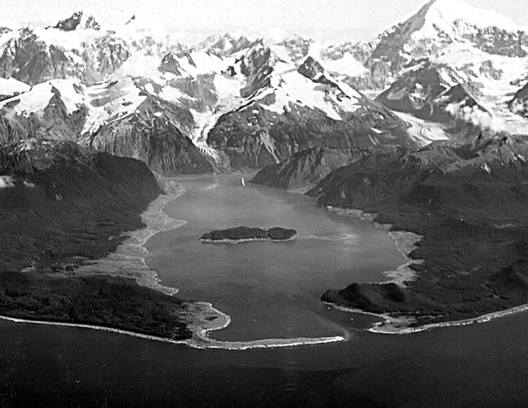
Lituya Bay (/lᵻˈtjuːjə/; Tlingit: Ltu.aa, meaning "Lake Within the Point") is a fjord located on the coast of the Southeast part of the U.S. state of Alaska. It is 14.5 km (9.0 mi) long and 3.2 km (2.0 mi) wide at its widest point. The bay was noted in 1786 by Jean-François de La Pérouse, who named it Port des Français. Twenty-one of his men perished in the tidal current in the bay.
Contents
Map of Lituya Bay, Alaska 99826, USA
Description
The smaller Cascade and Crillon Glaciers and the larger Lituya Glacier all spill into Lituya Bay, which is a part of Glacier Bay National Park and Preserve. Cenotaph Island is located roughly in the middle of the bay. The entrance of the bay is approximately 500 m (0.31 mi) wide, with a narrow navigable channel.
The bay is known for its high tides, which have a range of approximately 3 m (9.8 ft). Tidal currents in the entrance reach 9.4 km/h (5.1 kn). The entrance is considered dangerous to navigation, especially when the tidal currents are running, but the interior of the bay provides good protection to anchored ships.
Lituya Bay is also famous for four recorded tsunamis, in 1854, 1899, 1936, and 1958.
1958 megatsunami
The same topography that leads to the heavy tidal currents also created the highest wave from a tsunami in recorded history. On July 9, 1958, an earthquake caused a landslide in the Gilbert Inlet at the head of the bay, generating a massive megatsunami measuring between 100 ft (30 m) and 300 ft (91 m). The subsequent breaking wave possessed sufficient power to snap off all the trees up to 1,720 feet (520 m) high on the slope directly opposite the landslide. There were three fishing boats anchored near the entrance of Lituya Bay on the day the giant wave occurred. One boat sank and the two people on board were killed. The other two boats were able to ride the waves. Among the survivors were William A. Swanson and Howard G. Ulrich, who provided accounts of what they observed. Based on Swanson's description of the length of time it took the wave to reach his boat after overtopping Cenotaph Island near the bay's entrance, the wave may have been traveling 120 mph. When it reached the open sea, however, it dissipated quickly. This incident was the first direct evidence and eyewitness report of the existence of megatsunamis.