
 | ||
Doggerland
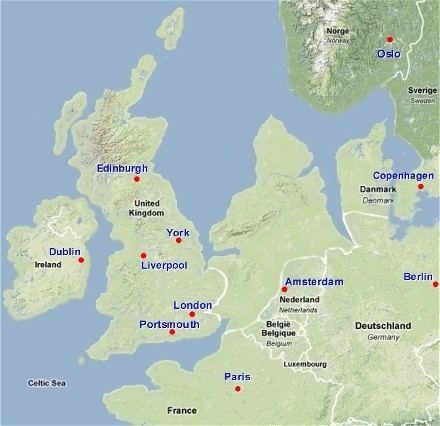
Doggerland was an area now beneath the southern North Sea that connected Great Britain to continental Europe during and after the last Ice Age. It was flooded by rising sea levels around 6,500–6,200 BCE. Geological surveys have suggested that it stretched from Britain's east coast to the Netherlands and the western coasts of Germany and the peninsula of Jutland. It was probably a rich habitat with human habitation in the Mesolithic period, although rising sea levels gradually reduced it to low-lying islands before its final submergence, possibly following a tsunami caused by the Storegga Slide.
Contents
- Doggerland
- Hidden histories welcome to doggerland
- Formation
- Disappearance
- Discovery and investigation by archaeologists
- In popular culture
- References
The archaeological potential of the area had first been identified in the early 20th century, but interest intensified in 1931 when a fishing trawler operating east of the Wash dragged up a barbed antler point that was subsequently dated to a time when the area was tundra. Vessels have dragged up remains of mammoth, lion and other animals, as well as a few prehistoric tools and weapons.
Doggerland was named after the Dogger Bank, which in turn was named after the 17th century Dutch fishing boats called doggers.
Hidden histories welcome to doggerland
Formation
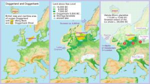
Until the middle Pleistocene, Britain was a peninsula of Europe, connected by the massive chalk Weald–Artois Anticline across the Straits of Dover. During the Anglian glaciation, approximately 450,000 years ago, an ice sheet filled much of the North Sea, with a large proglacial lake in the southern part fed by the Rhine, Scheldt and Thames river systems. The catastrophic overflow of this lake carved a channel through the anticline, leading to the formation of the Channel River, which carried the combined Scheldt and Thames to the Atlantic. This probably created the potential for Britain to become isolated from the continent during periods of high sea level, although some scientists argue that the final break did not occur until a second ice-dammed lake overflowed during the MIS8 or MIS6 glaciations, around 340,000 or 240,000 years ago.
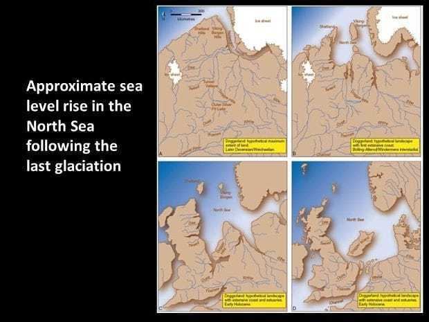
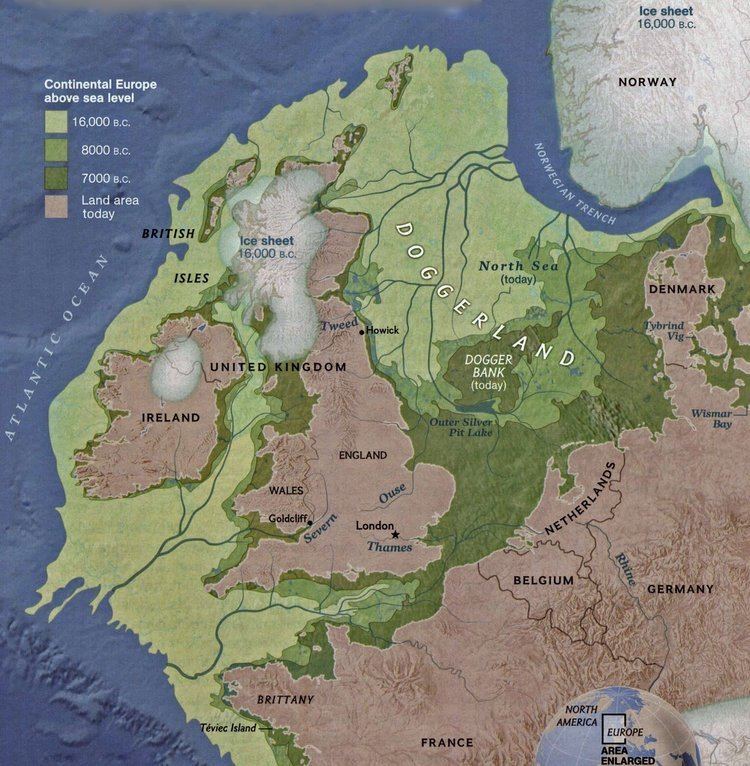
During the most recent glaciation of the Last Glacial Maximum, which ended around 18,000 years ago, the North Sea and much of the British Isles were covered with glacial ice and the sea level was about 120 m (390 ft) lower. Subsequently, the climate became warmer and during the Late Glacial Maximum around 12,000 BCE Britain, as well as much of the North Sea and English Channel, was an expanse of low-lying tundra.
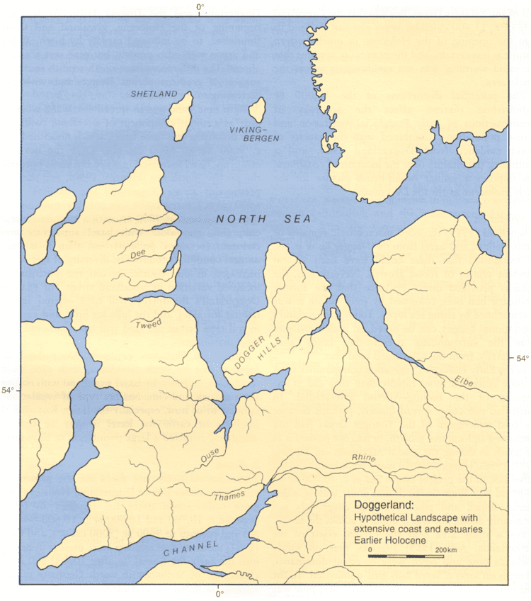
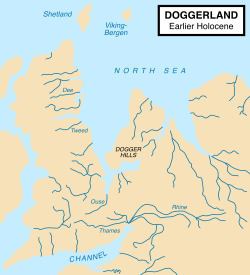
Evidence, including the contours of the present seabed, indicates that after the first main Ice Age, the watershed between the North Sea and English Channel extended east from East Anglia then south-east to the Hook of Holland, rather than across the Strait of Dover. The Seine, Thames, Meuse, Scheldt and Rhine rivers joined and flowed west along the English Channel as a wide slow river before eventually reaching the Atlantic Ocean. At about 8000 BC the north-facing coastal area of Doggerland had a coastline of lagoons, saltmarshes, mudflats and beaches as well as inland streams, rivers, marshes and lakes. It may have been the richest hunting, fowling and fishing ground in Europe in the Mesolithic period.
One big river system found by 3D seismic survey was the 'Shotton River', which drained the south-east part of the Dogger Bank hill area into the east end of the Outer Silver Pit lake. It is named after Birmingham geologist Frederick William Shotton.
Disappearance
As ice melted at the end of the last glacial period of the current ice age, sea levels rose and the land began to tilt in an isostatic adjustment as the huge weight of ice lessened. Doggerland eventually became submerged, cutting off what was previously the British peninsula from the European mainland by around 6500 BCE. The Dogger Bank, an upland area of Doggerland, remained an island until at least 5000 BC. Key stages are now believed to have included the gradual evolution of a large tidal bay between eastern England and Dogger Bank by 7000 BC and a rapid sea-level rise thereafter, leading to Dogger Bank becoming an island and Great Britain getting physically disconnected from the continent.
A recent hypothesis postulates that much of the remaining coastal land was flooded by a megatsunami around 6200 BCE, caused by a submarine landslide off the coast of Norway known as the Storegga Slide. This suggests: "that the Storegga Slide tsunami would have had a catastrophic impact on the contemporary coastal Mesolithic population.... Britain finally became separated from the continent and in cultural terms, the Mesolithic there goes its own way." A study published in 2014 suggested that the only remaining parts of Doggerland at the time of the Storegga Slide were low-lying islands, but supported the view that the area had been abandoned at about the same time as the tsunamis.
Another view speculates that the Storegga tsunami devastated Doggerland but then ebbed back into the sea, with the later bursting of Lake Agassiz (in North America) releasing so much fresh water that sea levels over about two years rose to flood much of Doggerland and make Britain an island.
Discovery and investigation by archaeologists
The prehistoric existence of what is now known as Doggerland was established in the late 19th century. H. G. Wells referred to the concept in his short story A Story of the Stone Age of 1897, set in "a time when one might have walked dryshod from France (as we call it now) to England, and when a broad and sluggish Thames flowed through its marshes to meet its father Rhine, flowing through a wide and level country that is under water in these latter days, and which we know by the name of the North Sea...Fifty thousand years ago it was, fifty thousand years if the reckoning of geologists is correct", though most of the action seems to occur in modern Surrey and Kent, but stretching out to Doggerland.
The remains of plants brought to the surface from Dogger Bank were studied in 1913 by paleobiologist Clement Reid, and the remains of animals and worked flints from the Neolithic period had also been found. In his book The Antiquity of Man of 1915, anatomist Sir Arthur Keith discussed the archaeological potential of the area. In 1931, the trawler Colinda hauled up a lump of peat whilst fishing near the Ower Bank, 40 kilometres (25 mi) east of Norfolk. The peat was found to contain a barbed antler point, possibly used as a harpoon or fish spear, 220 millimetres (8.5 in) long, which dated from between 4,000 and 10,000 BCE when the area was tundra.
Interest was reinvigorated in the 1990s by Professor Bryony Coles, who named the area "Doggerland" ("after the great banks in the southern North Sea") and produced speculative maps of the area. Although she recognised that the current relief of the southern North Sea seabed is not a sound guide to the topography of Doggerland, this topography has more recently begun to be reconstructed more authoritatively using seismic survey data obtained from oil exploration.
A skull fragment of a Neanderthal, dated at over 40,000 years old, was recovered from material dredged from the Middeldiep, some 16 kilometres (10 mi) off the coast of Zeeland, and exhibited in Leiden in 2009. In March 2010 it was reported that recognition of the potential archaeological importance of the area could affect the future development of offshore wind farms.
In July 2012, the results of a fifteen-year study of Doggerland by the universities of St Andrews, Dundee, and Aberdeen, including artefacts survey results, were displayed at the Royal Society in London. Richard Bates of St Andrews University said:
"We have speculated for years on the lost land's existence from bones dredged by fishermen all over the North Sea, but it's only since working with oil companies in the last few years that we have been able to re-create what this lost land looked like....We have now been able to model its flora and fauna, build up a picture of the ancient people that lived there and begin to understand some of the dramatic events that subsequently changed the land, including the sea rising and a devastating tsunami."
In September 2015, archaeologists at the University of Bradford announced their project to chart Doggerland in 3D, and to study DNA from deep sea core samples.