
Basin size 344 sq mi (890 km) | Length 24 km | |
 | ||
River mouth | ||
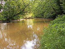
The Lake Fork is a tributary of the Mohican River, 14.7 miles (23.7 km) long, in north-central Ohio in the United States. Via the Mohican, Walhonding, Muskingum and Ohio Rivers, it is part of the watershed of the Mississippi River, draining an area of 344 square miles (891 km²).
Map of Lake Fork Mohican River, Knox Township, OH, USA
The Lake Fork is formed by the confluence of the Jerome Fork and the Muddy Fork in southeastern Ashland County, and flows generally south-southwestwardly into northwestern Holmes County, where it joins the Mohican River, about 3.5 miles (5.6 km) southeast of Loudonville.
In Ashland County, a 1936 U.S. Army Corps of Engineers dam causes the river to form Mohicanville Lake.
References
Lake Fork Mohican River Wikipedia(Text) CC BY-SA