
Basin size 999 sq mi (2,590 km) | Length 64 km | |
 | ||
Sources Clear Fork Mohican River, Black Fork Mohican River | ||
Mohican river trip
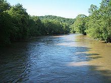
The Mohican River is a principal tributary of the Walhonding River, about 40 miles (64 km) long, in north-central Ohio in the United States. Via the Walhonding, Muskingum and Ohio Rivers, it is part of the watershed of the Mississippi River, draining an area of 999 square miles (2,587 km²).
Contents
Map of Mohican River, Ohio, USA
The Mohican River is formed in Ashland County, about 2 miles (3 km) southwest of Loudonville, by the confluence of the Black Fork and the Clear Fork. It then flows generally south-southeast through western Holmes and northeastern Knox Counties, past the community of Brinkhaven, into northwestern Coshocton County, where it joins the Kokosing River to form the Walhonding River. It collects the Lake Fork in Holmes County.
Near Brinkhaven the river is spanned by the Bridge of Dreams, the longest covered bridge in Ohio.
Variant names and spellings
The river was named after the Mohican Indian tribe. According to the Geographic Names Information System, the Mohican River has also been known historically as: