
Basin countries United States Average depth 3 m (9.8 ft) Mean depth 3 m | Surface area 730 km (280 sq mi) Area 730 km² Catchment area 38,000 km² | |
 | ||
Primary inflows Inflow source Mississippi River, Mississippi River–Gulf Outlet Canal | ||
Odd ball trout in lake borgne with outkast charters
Lake Borgne is a lagoon of the Gulf of Mexico in southeastern Louisiana. Due to coastal erosion, it is no longer actually a lakebut rather an arm of the Gulf of Mexico. Its name comes from the French word borgne, which means "one-eyed."
Contents
- Odd ball trout in lake borgne with outkast charters
- Map of Lake Borgne E LA USA
- GeographyEdit
- EcologyEdit
- References
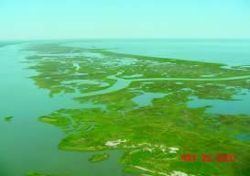
Map of Lake Borgne, E, LA, USA
GeographyEdit
The three large lakes -- Maurepas, Pontchartrain, and Borgne—cover 55% of the Pontchartrain Basin. A brackish marsh land bridge and Lake St. Catherine separate Lake Pontchartrain from Lake Borgne. The Rigolets and Chef Menteur Pass are the two open water connections between Pontchartrain and Borgne.
Due to coastal erosion, Borgne is now a lagoon connecting to the Gulf of Mexico, but early 18th century maps show it as a lake largely separated from the Gulf by a considerable extent of wetlands which have since disappeared. In a 1902 case before the United States Supreme Court over the oyster banks at the boundary between Louisiana and Mississippi, the State of Mississippi argued that at the time of Louisiana's admission into the Union, there probably was no such "Lake Borgne" or "Mississippi Sound".
The basin contains 483,390 acres (1956 km²) of wetlands, consisting of nearly 38,500 acres (156 km²) of fresh marsh, 28,600 acres (116 km²) of intermediate marsh, 116,800 acres (473 km²) of brackish marsh, 83,900 acres (340 km²) of saline marsh, and 215,600 acres (873 km²) of cypress swamp. Since 1932, more than 66,000 acres (267 km²) of marsh have converted to water in the Pontchartrain Basin — over 22% of the marsh that existed in 1932.
The primary causes of wetland loss in the basin are the interrelated effects of human activities and the estuarine processes that began to predominate many hundreds of years ago, as the Mississippi River delta was abandoned.
The 1.8-mile-long (2.9 km) IHNC Lake Borgne Surge Barrier was constructed by the Army Corps of Engineers as part of the Hurricane and Storm Damage Risk Reduction System (HSDRRS) for southeast Louisiana in response to Hurricane Katrina. The project cost approximately $1.1 billion and was built at the confluence of the Gulf Intracoastal Waterway and the MRGO. It is the largest design-build civil works project in the history of the Corps.
EcologyEdit
The Mississippi River levees significantly limit the input of fresh water, sediment, and nutrients into the Pontchartrain basin. This reduction in freshwater input plays a role in the critical problem of the Pontchartrain Basin — increased salinity. The construction of the Mississippi River–Gulf Outlet Canal (MRGO), which breaches the natural barrier of the Bayou La Loutre ridge and the Borgne land bridge, has allowed sea water to push farther into the basin. Relative sea level rise of up to 0.96 feet per century also gives saltier waters greater access to surrounding wetlands. As a result, mean monthly salinities have increased since the construction of the MRGO and other canals. In recent years, salinities have stabilized. The heightened salinity has stressed wetlands, especially freshwater marshes and swamps.
Since 1932, approximately 24% of the Borgne Land Bridge has been lost to severe shoreline retreat and rapid tidal fluctuations, and the loss rate is increasing. During the same time, 17% of the Maurepas Land Bridge marshes disappeared due to subsidence and spikes in lake salinity. These land bridges prevent estuarine processes, such as increased salinity and tidal scour, from pushing further into the middle and upper basins. Additionally, from 1968 to 1988, 32% of the cypress swamp on the land bridge had either converted to marsh or became open water. If these buffers are not preserved, the land loss rates around Lakes Pontchartrain and Maurepas will increase dramatically.
Several marshes in the basin are vulnerable to rapid loss if adequate protection is not quickly provided.