
 | ||
Bridges Galveston Causeway, Belle Chasse Tunnel | ||
The Gulf Intracoastal Waterway is the portion of the Intracoastal Waterway located along the Gulf Coast of the United States. It is a navigable inland waterway running approximately 1,050 mi (1,690 km) from Carrabelle, Florida, to Brownsville, Texas.
Contents
- Map of Gulf Intracoastal Waterway 12 LA 70764 USA
- EHL WHL mileages
- Connecting waterways
- Ports and harbors
- References
Map of Gulf Intracoastal Waterway, 12, LA 70764, USA
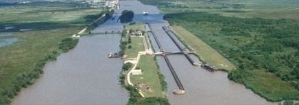
The waterway provides a channel with a controlling depth of 12 ft (3.7 m), designed primarily for barge transportation. Although the U.S. government proposals for such a waterway were made in the early 19th century, the Gulf Intracoastal Waterway was not completed until 1949.
EHL & WHL mileages
Locations along the Gulf Intracoastal Waterway are defined in terms of statute miles (as opposed to nautical miles, in which most marine routes are measured) east and west of Harvey Lock, a navigation lock in the New Orleans area located at 29.909°N 90.084°W / 29.909; -90.084. The Hathaway Bridge in Panama City, Florida, for example, is at mile 284.6 EHL (East of Harvey Lock). The Queen Isabella Causeway Bridge at South Padre Island is at mile 665.1 WHL (West of Harvey Lock).
Connecting waterways
The Gulf Intracoastal Waterway crosses or meets, and in some cases is confluent with, numerous other navigable rivers and waterways. They include:
Ports and harbors
Many of the busiest ports in the United States in terms of tons of cargo are located on or near the Gulf Intracoastal Waterway. Notable ports on or near the waterway include:
Florida
Alabama
Mississippi
Louisiana
Texas