
Country Brazil Time zone UTC-3 (UTC-3) Local time Friday 1:19 AM | State Goiás HDI (2000) 0,793 – high Elevation 708 m Population 88,048 (2010) | |
 | ||
Region Southwest Goiás Microregion Weather 22°C, Wind NE at 5 km/h, 84% Humidity University Federal University of Goiás | ||
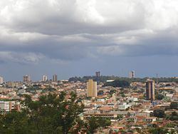
Jataí, Goiás, Brazil is a municipality in southern Goiás state, Brazil. Its population was 105,402 (2012) in a total area of 7,174.2 km². (10/10/2002) Jataí is a major producer of agricultural products, including soybeans, rice, and corn. It has the largest herd of cattle in the state and is a large producer of poultry and swine. In 2000 it was the 6th largest municipality in area in the state.
Contents
- Map of JataC3AD State of GoiC3A1s Brazil
- Location
- Climate
- Rivers
- History
- Political data
- Demographic data
- Economy
- Economic data
- Multinational Enterprises in Jata
- Animal raising 2006
- Agricultural data 2006
- Infrastructure
- Education 2006
- Health 2007
- The Human Development Index
- References
Map of Jata%C3%AD, State of Goi%C3%A1s, Brazil
Location
It is located in the southwest part of the state at the confluence of the São Pedro and Claro rivers. The state capital of Goiânia is 316 km. away. Highway connections are made by BR-060 / Abadia de Goiás / Guapó / Indiara / Acreúna / Santo Antônio da Barra / Rio Verde. See Sepin
Geographical limits: Caiapônia, Mineiros, Itarumã, Aparecida do Rio Doce, Caçu, Cachoeira Alta, Rio Verde, Mineiros and Serranópolis.
Jataí is part of the Southwest Goiás Microregion, which has a population of 330,490 inhabitants in 18 cities and a total area of 56,293.30 km².
Climate
Climate: Tropical mesothermic, with two seasons well defined by the seasonal regime of rain. Period of rain: October to April. Period of drought: May to September. Temperature: average minimum and maximum in June (coldest month) is: 11 °C - 27 °C. In September (hottest month): 18 °C - 35 °C. Temperatures can reach as high as 38 °C and as low as 2 °C during the year. A surprising 0 °C was recorded on July 18, 2000. Precipitation: rainfall of approximately 1,800mm, but badly distributed throughout the year.
Rivers
The municipality is located in the Serra do Caiapó, which divides the basins of the Araguaia and the Parnaíba rivers. Its hydro graphic network belongs to the basin of the Paraná, being composed of tributaries on the right bank of the Parnaíba.
Rivers: Claro, São Pedro, Doce, Ariranha e Paraíso. The water is supplied by the Claro river and distributed to the population after treatment.
History
The history of Jataí, like that of all the southwest of Goiás, makes up the last phase of the expansion of cattle. In 1836 José Manoel Vilela, from Minas Gerais, came from the east, crossing the Rio Verde. He set up a cattle ranch on the banks of the Rio Claro. Soon a settlement was formed with the name "Paraíso". In 1864 a district was formed with the name Paraíso de Jataí. The first church was built in 1867. In 1882 the municipality of Paraíso was created. Later, in 1885, the name was changed to Jataí.
Political data
Demographic data
(1)Estimated by logistic method
Economy
Jataí has a number of small-sized commercial establishments and service-providing enterprises. Its economy is mostly based on agriculture (soy, rice, corn, beans, and bananas), cattle, pig, and chicken raising, although commerce and transformation industries—especially the clothing industry—play an important role, they are highly dependent on the town's agribusiness. In 2005 the biggest employer was commerce with 3,811 workers, followed by public administration with 2,969 workers, and industry with 2,828 workers. (IBGE)
Economic data
Multinational Enterprises in Jataí
Animal raising (2006)
Agricultural data (2006)
Infrastructure
There are three institutes of higher education, including a campus of the Federal University of Goiás. This campus features 9 courses distributed in three academic units: the Center of Human Sciences, Letters, and Exact Sciences, the Center of Physical Education and the Center of Agricultural and Biological Sciences.
In the health sector there were four hospitals, 11 clinics, and one maternity.
In communications there were 5 radio stations and two local television stations. In addition there were 2 newspapers.
Education (2006)
Health (2007)
The Human Development Index
Data are from 2000
For the complete list see Frigoletto