
Time zone IST (UTC+5:30) Local time Wednesday 9:09 PM | State Kerala Taluks Iritty Telephone code 91 (0)490 ISO 3166 code ISO 3166-2:IN | |
 | ||
Weather 27°C, Wind NW at 3 km/h, 95% Humidity | ||
Kannur iritty kanjirakolly falls
Iritty is a Municipality (Malayalam: ഇരിട്ടി നഗരസഭ) and a taluk in the district of Kannur in the state of Kerala, India. The town is the main market place for the farmer communities in the surrounding regions. Iritty is known as The Coorg Valley in God's Own Country. Iritty is one of the fast upcoming towns in Kerala and one among four taluks in Kannur district..
Contents
- Kannur iritty kanjirakolly falls
- Map of Iritty Kerala
- Valathode waterfalls iritty kannur
- Location
- Geography
- Steel bridge
- Villages in Iritty Taluk
- Etymology
- Transportation
- Commerce
- Institutions Government Firms in Iritty
- Hospitals
- Blood Bank
- Higher Education Technical Education IT Education
- Govt Aided Unaided Schools
- Pilgrim Centres Religious Centres
- Tourism
- Notable residents
- References
Map of Iritty, Kerala
Valathode waterfalls iritty kannur
Location
Iritty is located on the banks of Valapattanam River, which is originated from nearby Kodagu hills and Kottiyoor mountains. Iritty is situated on the Thalassery-Coorg-Mysore highway. Nearby smaller towns are Mattannur, Peravoor, Payam, Kakkayangadu, Keezhppally, Vallithode, Karikkottakary, Angadikadavu, Anappanthy, Edoor, Ulikkal, Vattiyamthode, Manikkadave, Kilyianthara, Punnad, Charal, Edapuzha, uruppumkutti and Chavassery.
Aralam Wildlife Sanctuary is situated 8 kilometres (5 mi) from Iritty.
Geography
Iritty is surrounded by hills. A river flowing through Iritty is more commonly known as Iritty Puzha/Iritty River. Tourists visiting Iritty have the option of staying at a number of riverside Tourist homes, from where they can view the Iritty river. There is a steel girder bridge, built in 1933, over the river. There is a Dam in the place Pazhassi for irrigation purpose named 'PazhassiDam'. it is almost 10 km from the town. Wayanad tourist destinations are near from this place.The nearby areas are depending for their most of the shopping Iritty. Payam, Vallithode, Kilyianthara, Kondambra,Kolikkadavu, keezhur, Ulickal, Vattiyamthode, Mattara, Kalanki, Manikadave, Manippara Perumpally, Nuchiyad, Vayathoor, Edoor, Peratta, Karikottakari, Angadikadave, Kootupuzha, Charal, Alathupramba, Thermala, Urathoor etc. are the nearby small towns around.
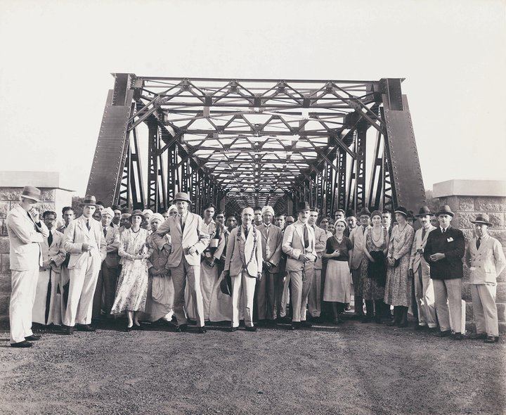
Steel bridge
The steel bridge in Iritty is a 10-ton bridge constructed in 1933 by the British authorities to connect the towns of Kodagu and Thalassery. It was designed by George Anderson of the Institution of Civil Engineers. A July 2015 death of a man after being accidentally wedged between the handrail and a private bus raised concerns about the bridge's age.
Villages in Iritty Taluk
Iritty Taluk has 19 villages
Etymology
Iritty, one of the beautiful hill side towns in the north Malabar of Kerala. The beauty of Iritty lies together with the unique rivers, streams, green hills and valleys. The main Streams of Iritty river are by the three rivers such as Bavali river, Aralam river and Barapuzha(Veni river). Before the name 'Iritty,' made the first cry, this land was nourished by two main rivers, one Barapuzha and Bavalipuzha . People started calling both the rivers confluence as Iratta puzha ( Double River & 'Puzha' means River ), and in course of time the land became Iritty...
Transportation
Iritty lies at an equal distance from the nearby cities of Kannur, Thalassery, Mahe, Taliparamba and Virajpet (Karnataka State). An interstate highway passes through Iritty connecting Thalassery and Kodagu. This was initially called the TC Road by the British. Now it refers to the Thalassery end of the highway. This highway is used by interstate bus services plying to Madikeri, Mysore and Bangalore. Keezhur is the starting point of Iritty town.
This place is well-connected by road from both Kannur and Thalassery. There are frequent buses from Iritty and to both these places and to several places across Kerala including Kottayam, Cochin (Ernakulam), Kasaragod, Panathur, Malom, Cherupuzha, Wayanad and Kozhikode. There is no railway line, with the nearest railway stations at Kannur and Thalassery. The nearest airport is Calicut International Airport at Kozhikode. Kannur International Airport, under construction at Mooorkhanparamba near Mattannur in Kannur district was expected to be operational by the end of 2014 and is located 18 km south-west of Iritty.
Commerce
Iritty is one of the major towns of the Kannur district. With nearby villages which produce cash crops and plantation crops, Iritty is a major commercial town too. It is one of the growing towns in the district. Iritty is famous for cash crops such as pepper, rubber and cashew nuts, some of which are sold under regional brands in various auction houses and commodities markets.
Iritty is primarily a trading town. Iritty is headquarters to several State Government offices.Most of these offices have jurisdiction over nearby towns like Mattanur and Peravoor.
Institutions / Government Firms in Iritty
Hospitals
Blood Bank
Higher Education/ Technical Education/ IT Education
Govt/ Aided/ Unaided Schools
Pilgrim Centres & Religious Centres
Tourism
Iritty and the surrounding areas have a choice of tourism attractions.