
Length: 111.57 mi (179.55 km) North end: I‑95 in Hopkinton, RI | Existed: 1958-1964 – present | |
 | ||
Counties: | ||
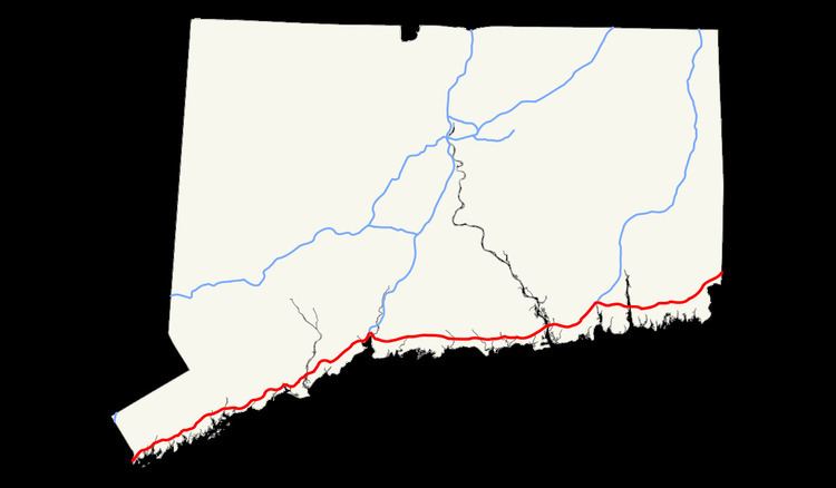
Interstate 95 is the main north–south Interstate Highway on the East Coast of the United States, running in a general east–west compass direction for 111.57 miles (179.55 km) in Connecticut, from the New York state line to the Rhode Island state line. I-95 from Greenwich to East Lyme is part of the Governor John Davis Lodge Turnpike, formerly known as the Connecticut Turnpike, during which it passes through major cities Stamford, Bridgeport, and New Haven . After leaving the turnpike in East Lyme, I-95 is known as the Jewish War Veterans Memorial Highway and passes through New London, Groton, and Mystic, before exiting the state at the Rhode Island border.
Contents
Route description
Interstate 95 enters Connecticut as the Connecticut Turnpike in Greenwich at the New York state line. The Connecticut Turnpike stretches for 128 miles (206 km) across the state, but only the first 88 miles (142 km) of the Connecticut Turnpike are signed as I-95. The Turnpike portion of I-95 passes through the most heavily urbanized section of Connecticut along the shoreline between Greenwich and New Haven, going through the cities of Stamford, Norwalk, Bridgeport, and New Haven, with daily traffic volumes of 120,000 to over 150,000 throughout the entire 48-mile (77 km) length between the New York state line and the junction with I-91 in New Haven. The Turnpike intersects with several major expressways, namely US 7 at Exit 15 in Norwalk, Route 8 and Route 25 at Exit 27A in Bridgeport (quickest way to I-84 from southwest CT), the Merritt and Wilbur Cross Parkways at Exit 38 (via the Milford Parkway) in Milford, and Interstate 91 at Exit 48 in New Haven.
North (east) of I-91, the Turnpike continues along the Connecticut shoreline with a smaller amount of volume. The six-lane highway is reduced to four lanes in Branford, interchanges with Route 9 at Exit 69 in Old Saybrook, crosses the Connecticut River on the Raymond E. Baldwin Bridge in a concurrency with US 1, and continues until the interchange with Interstate 395 at Exit 76 near the East Lyme-Waterford line. After Exit 76, the Turnpike continues on I-395, while I-95 continues east through New London, Groton, Stonington, and North Stonington towards the Rhode Island state line.
Going southbound, the last exit before the Connecticut Turnpike segment is Exit 80 for Oil Mill Road. The first exit northbound is Exit 81 for Cross Road. Just before the Cross Road exit is a weigh station. The road then enters Waterford and intersects with Route 85 at Exit 82. Exit 82A northbound is for a Frontage Road of I-95 and has access to shopping malls. Exit 83 differs in each direction. Going southbound, Exit 83 is for US 1 South, the Frontage Road, and the shopping malls. Going northbound, however, Exit 83 is for Route 32 and downtown New London.
Exits 84S, 84N, and 84E, only going southbound, are for Route 32, Norwich, and downtown New London. Exit 85 is northbound only and is for US 1 North as it leaves a concurrency with I-95 over the Gold Star Bridge, which crosses the Thames River. Exit 86 is in both directions for Routes 12 and 184 in Groton. Accessible from Exit 86 is the Groton Sub Base. Exit 87 is for Route 349, also known as the Clarence B. Sharp Memorial Highway. A mile after Exit 87, Exit 88 leaves for Route 117 and Noank. Just short of three miles (5 km) later, I-95 enters Mystic and interchanges with Allyn Street at Exit 89 and Route 27 at Exit 90. Route 234 interchanges three miles (5 km) after Exit 90 at Exit 91. Exit 92 is for Routes 2 and 49. Route 2 East provides access to Route 78, which leads to the beaches of southwestern Rhode Island, while Route 2 West provides access to Foxwoods Casino. Exit 93 is the final exit before Rhode Island and is for Routes 216 and 184. Interstate 95 then enters Rhode Island after 111.57 miles (179.55 km).
Auxiliary routes
Disasters
In January 1983, a truck with a brake failure slammed into a line of cars waiting to pay a toll on I-95 in Stratford, Connecticut. Seven people were killed. This accident helped lead to the removal of toll barriers throughout Connecticut, which was completed six years after.
On the morning of June 28, 1983, a 100 foot (30 m) section of the Mianus River Bridge in Cos Cob collapsed, plunging northbound I-95 traffic into the Mianus River below, killing three. The collapse was blamed on the failure of the steel pins to hold the horizontal beams together and inadequate inspection prior to the collapse. Northbound traffic was diverted on this section of I-95 for 25 days. Southbound traffic was unaffected.
On March 26, 2004, a bridge on I-95 in Bridgeport, Connecticut was partly melted by the explosion of a tanker truck carrying over 11,900 gallons (45,000 L) of fuel oil. Repairs were estimated to take at least two weeks, but the highway was opened to northbound traffic in only a few days. Southbound traffic resumed about a week later after a temporary bridge was installed to carry traffic while the destroyed bridge was rebuilt.
At 10:20 AM on November 2, 2007, a tanker truck carrying heating oil plowed over the divider, knocking the side of a tractor trailer and striking several other cars in its path. Three people were killed, including the driver of the tanker and the occupants of two cars that were completely destroyed in the crash. The driver of the tractor trailer survived (his Pit Bull canine companion emerged completely unharmed) but the trailer was split open. At least three other cars were involved in this accident. A part of the road was damaged and took until the next morning to fully reopen, partly due to a cleanup after the accident.
History
Interstate 95 in Connecticut has far more exits than typical Interstate Highways, particularly in Fairfield and New Haven Counties, with some exits less than one mile (1.6 km) apart. State transportation officials have said that the reason for the many exits stems from the state's original justification for building parts of the highway — to ease traffic congestion on Route 1 by providing a faster alternate route, even for drivers traveling short distances within the same community. To overcome potential opposition to the highway from towns through which the route would traverse, the State of Connecticut agreed to guarantee each affected town a certain number of access points to the highway. Rather than skirting urban areas, the highway was built directly through the most dense sections of Stamford, Norwalk, Bridgeport, and New Haven.
While most of I-95 was built as the Connecticut Turnpike, the Connecticut Turnpike incorporated several pieces of already-built relocations, some to freeway standards, of U.S. Route 1 (the Turnpike split from the US 1 relocation in East Lyme, along the Old Lyme-New London section):
Other improvements in the corridor included the New York-Meriden Merritt Parkway/Wilbur Cross Parkway, New Haven-Old Saybrook Route 80, and Groton-Rhode Island Route 184, the latter connecting in Rhode Island to Route 3, a shortcut to Providence.
Most of the Turnpike opened January 2, 1958, and was designated I-95 south/west of the split with the relocated US 1 by 1959. The rest of I-95 from I-395 to the Connecticut-Rhode Island border opened December 12, 1964. The Gold Star Bridge was twinned circa 1975, along with a reconstruction of its approaches, and in 1993 the Raymond E. Baldwin Bridge was replaced with a wider span.
The state installed cameras to watch traffic along the highway in the early 1990s. As of 2007, about 100 cameras have been set up and are monitored by state police and the state Department of Transportation. In Fairfield County, local emergency responders (fire departments and ambulance services) that serve the highway in individual towns have asked for direct feeds from the cameras to avoid mistakes. When travelers report an accident, they sometimes tell authorities that it occurred near an exit that is actually not the nearest to the scene, slowing down response time. The traffic feed from the cameras is available on the World Wide Web, but the service can be spotty, according to the Stamford, Connecticut and Norwalk, Connecticut fire chiefs, who said they were hoping that a proposed $40 million upgrade of the camera system, under consideration by the state in 2007, would provide them access. Feeds from these cameras are also used by local media outlets, as part of traffic report segments in news programming, and in some instances as a part of a designated "Traffic and Weather" Channel.
Construction plans
While the corridor was designated "High Priority Corridor 65" in 2005, work along Interstate 95 in Connecticut has been ongoing for nearly 20 years.
Interstate upgrades
Mass transit upgrades
These projects have been undertaken in large part to reduce traffic on the highway, which is often congested, particularly in Fairfield County:
Scenic overlook
Between exits 89 and 90 eastbound is the Jerome Hoxie Scenic Overlook. This overlooks Mystic Cove.
Exit list
Exit numbers are currently sequential, but will be changed to mileage-based in the future.