
NECTA New Haven Incorporated 1826 Elevation 68 m Population 18,114 (2013) | Region South Central Region Time zone Eastern (UTC-5) Zip code 06443 Local time Friday 12:28 PM | |
 | ||
Weather 3°C, Wind NW at 18 km/h, 31% Humidity | ||
Fairy gardens garden club of madison connecticut
Madison is a town in the southeastern corner of New Haven County, Connecticut, United States, occupying a central location on Connecticut's Long Island Sound shoreline. The population was 18,269 at the 2010 census.
Contents
- Fairy gardens garden club of madison connecticut
- Map of Madison CT 06443 USA
- A week in madison connecticut
- Beaches
- Geography
- Principal communities
- Madison Center
- Education
- Demographics
- Transportation
- Camp Hadley
- List of National Historic Sites in Madison
- Notable people
- Sister city
- References
Map of Madison, CT 06443, USA
Madison was first settled in 1641. Throughout the 18th century, Madison was known as East Guilford until it was incorporated as a town in 1826. Since then, Madison and Guilford have shared many cultural and economic similarities despite an unofficial high school rivalry.
Bill Clinton favorably mentions the town in his autobiography, My Life.
A week in madison connecticut
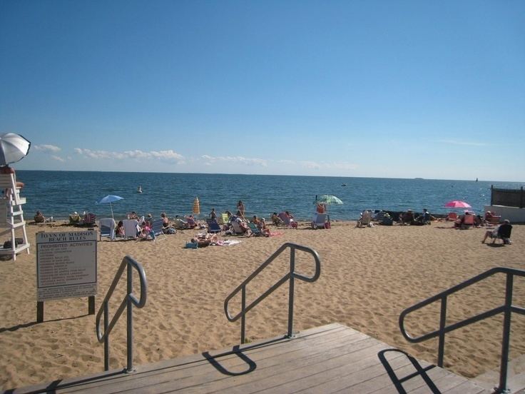
Beaches
Hammonasset Beach State Park possesses the state's longest public beach, with campsites, picnic areas, and a fishing pier, and is extremely popular in the summer, causing traffic jams on I-95 on peak days.
Surf Club Beach is the town's major public beach with lifeguards and recreational facilities for baseball, softball, basketball, volleyball, and horseshoes. It features playgrounds for children and picnic tables for families, as well as sailboat and kayak racks. It is also home to several athletic fields, including Strong Field, the town's multi-purpose athletic complex.
East Wharf, sometimes referred to as the "purple sand beach," has lifeguards, a pier, kayak and sailboat racks in addition to a gazebo.
West Wharf has a pier, rock formations to the west, a small sunbathing beach and boat spaces.
The Madison Beach Club has its own beach and is located near Madison Country Club, a private golf course.
Geography
According to the United States Census Bureau, the town has a total area of 36.8 square miles (95.3 km²), of which 36.2 square miles (93.8 km²) is land and 0.6 square miles (1.5 km²), or 1.6%, is water. Madison is bordered by the municipalities of Clinton and Killingworth to the east, Durham to the north, Guilford to the west, and Long Island Sound to the south.
Principal communities
Madison Center
Madison's center of town is the main area for businesses and the location of the town library and Madison Green Historic District. Madison Center is a census-designated place, with a population of 2,290 at the 2010 census. The center has many boutiques and eateries. Although it is called "the center," it is not the geographic center of Madison, but is located in the southern part of town, halfway between Clinton and Guilford.
Education
Madison Public Schools serve grades K-12 and include Ryerson Elementary School, Island Avenue Elementary School, Jeffery Elementary School, Brown Middle School, Polson Middle School, and Daniel Hand High School. Year-round residents boast of a superior school system, an expansive recreational program and many opportunities for volunteer work. In 2013, Madison ranked as number 9 on the CBS News list of most-attractive school districts in the United States.
Private elementary schools in Madison include Our Lady of Mercy School, The Country School, and Grove School.
The E.C. Scranton Memorial Library was a 1901 gift to the townspeople from Mary Scranton. The original building was designed by architect Henry Bacon, who later designed the Lincoln Memorial. A 1906 postcard shows the library as it appeared at that time. After an expansion in 1989, the main building (in the postcard at right) became the children's section, and the expansion to the right of the main door became the main entrance. As of 2006, this popular library featured 114,000 volumes and had an average of 360 visits per day and 860 programs per year.
Demographics
As of the 2000 census, there were 17,858 people, 6,515 households, and 5,120 families residing in the town. The population density was 493.3 people per square mile (190.5/km²). There were 7,386 housing units at an average density of 204.0 per square mile (78.8/km²). The racial makeup of the town was 96.62% White, 0.40% African American, 0.06% Native American, 1.71% Asian, 0.01% Pacific Islander, 0.25% from other races, and 0.94% from two or more races. Hispanic or Latino of any race were 1.34% of the population.
There were 6,515 households, out of which 39.1% had children under the age of 18 living with them, 69.8% were married couples living together, 6.6% had a female householder with no husband present, and 21.4% were non-families. 18.5% of all households were made up of individuals and 8.5% had someone living alone who was 65 years of age or older. The average household size was 2.72 and the average family size was 3.12.
The town's population was distributed with 28.2% under the age of 18, 3.8% from 18 to 24, 25.3% from 25 to 44, 28.6% from 45 to 64, and 14.1% who were 65 years of age or older. The median age was 41 years. For every 100 females, there were 93.2 males. For every 100 females age 18 and over, there were 89.8 males.
The median income for a household in the town was $87,437, and the median income for a family was $101,297. Males had a median income of $73,525 versus $41,058 for females. The per capita income for the town was $40,537. About 0.9% of families and 1.3% of the population were below the poverty line, including 0.5% of those under age 18 and 2.4% of those age 65 or over.
Transportation
The Madison train station is served by the Shore Line East commuter railroad, with service to New Haven's Union Station to the west and the Old Saybrook train station to the east, facilitating connections to the MTA's Metro-North Railroad and to Amtrak's Northeast Regional and Acela Express services. Similarly, the Estuary Transit District provides public transportation between Madison Center and Old Saybrook along U.S. Route 1 through its "9 Town Transit" service, and the Connecticut Transit "S" bus travels between Madison Center and New Haven.
Major roads in Madison include Interstate 95, U.S. Route 1, and state highway Routes 79 and 80.
From 1931 to 2007, Madison was served by Griswold Airport.
Camp Hadley
In 1935–1942, Madison served as the site of Camp Hadley, one of 23 Civilian Conservation Corps (CCC) camps in Connecticut. In the winter of 2013, Daniel Hand High School math teacher and 'Woodsy Club' advisor Jason Engelhardt led an iniatiative to clean and preserve the site.