
Constructed 15 September 1955 | Length 92.55 km | |
 | ||
Existed: September 15, 1955 by FHWAJuly 1, 1964 by Caltrans – present North end: King Street, 5th Street in San Francisco Highway system US Interstate highway system | ||
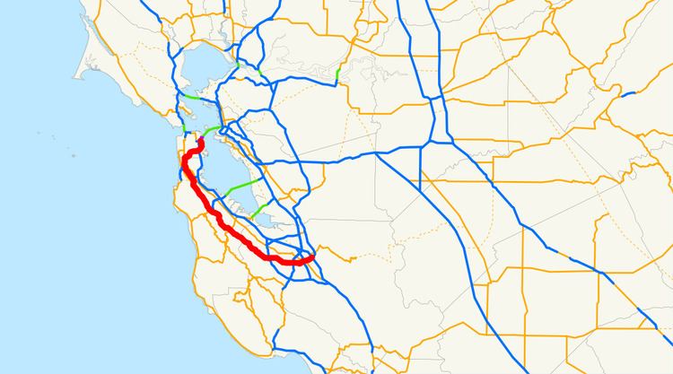
Interstate 280 (I-280) is a 57-mile (92-km) long north–south Interstate Highway in the San Francisco Bay Area of Northern California. It connects San Jose and San Francisco, running along just to the west of the larger cities of San Francisco Peninsula for most of its route.
Contents
Map of I-280, California, USA
I-280 from its southern terminus at U.S. 101 and Interstate 680 north to Interstate 880 in San Jose is part of the Sinclair Freeway (named after Joseph P. Sinclair, District Engineer for District 4 California Division of Highways). From I-880 to State Route 1 in Daly City, I-280 was built and dedicated as the Junipero Serra Freeway, after the Spanish Franciscan friar who founded the first nine of 21 Spanish missions in California from San Diego to San Francisco. One of the dedication signs (in Daly City) still indicates that the Junipero Serra Freeway is known as the "World's Most Beautiful Freeway" due to its scenic route through the San Francisco Peninsula. From State Route 1 to the James Lick Freeway (U.S. 101) in San Francisco it is officially called the John F Foran Freeway (after a former member of the California State Legislature), but is more commonly referred to by its original name, the Southern Freeway. And from the James Lick Freeway to its northern end at King Street and Fifth Street, I-280 is called the Southern-Embarcadero Freeway.
This route is part of the California Freeway and Expressway System and is eligible for the State Scenic Highway System.
I-280 is one of two 3-digit Interstate designations to appear on opposite coasts of the United States. I-110 in California and Florida is the only other designation.
In more recent years, Interstate 280 has become well-known due to it being shown prominently on the app icon for iOS built-in Google Maps app (and later Apple Maps); this is related to I-280's route through Cupertino, just over the fence north of Apple's headquarters.
Route description
The southern end of Interstate 280 begins at U.S. 101 in San Jose, where it acts as a continuation of Interstate 680 westward. In between San Jose and San Francisco, Interstate 280 passes through Santa Clara, Cupertino, Los Altos and Los Altos Hills before it settles along its scenic route just to the west of the cities of the San Francisco Peninsula in San Mateo County and just to the east of the Santa Cruz Mountains. I-280 re-emerges in a decidedly urbanized area in the city of San Bruno, passing through South San Francisco and Daly City before it runs across a southeastern swath of the city of San Francisco on the way to its northern terminus.
The segment of the Junipero Serra Freeway between Cupertino and Daly City has been called the "World's Most Beautiful Freeway" since its dedication in the 1960s. Drivers along this portion of Interstate 280 are treated to scenic views of the Santa Cruz Mountains to the west and, at a few points, San Francisco Bay to the east, and are isolated by hills from the cities to the east. Through much of this segment, the freeway is actually running just inside the eastern rim of the rift valley of the San Andreas Fault. A particularly attractive 6-mile (10 km) stretch of the freeway from Hillsborough to Belmont provides a beautiful look at Crystal Springs Reservoir, formed by water piped over 160 miles (260 km) from Hetch Hetchy Valley in Yosemite National Park, partly filling the rift valley.
For nearly all of its length, Interstate 280 runs roughly parallel and several miles to the west of U.S. 101 (the Bayshore Freeway). Both freeways are north–south routes connecting San Jose with San Francisco; however, unlike I-280, the route that U.S. 101 takes between the two cities goes entirely through urbanized areas. The majority of the population of the San Francisco Peninsula lives somewhere between Interstate 280 and U.S. 101.
I-280 never intersects with Interstate 80, its parent interstate. The northern terminus of I-280 is within about a mile of I-80's western terminus (at the approach to the San Francisco–Oakland Bay Bridge), but the two interstates do not directly connect. Although San Francisco has had several opportunities to connect I-280 to I-80, it has chosen to use the money for other purposes. Connecting the two freeways is considered to be politically and financially infeasible at this time, due to the city's strong anti-freeway stance. Instead, 280's northernmost extension primarily functions as a spur into Downtown San Francisco, as suggested by signage on northbound U.S. Route 101 at its San Francisco interchange with I-280.
Most of I-280, in San Jose to Daly City, is designated as the Junipero Serra Freeway in honor of Spanish missionary Junípero Serra, who founded many of California's missions in the 18th century. A 26-foot (8 m) high faux-sandstone statue of Father Serra kneeling and pointing over the freeway is located at a highway rest area just north of the Highway 92 intersection between the Bunker Hill Drive and Black Mountain Road exits on northbound I-280 in Hillsborough, and can be clearly seen by drivers in both directions. The segment of Interstate 280 north of SR 1 in San Francisco was originally named the Southern Freeway, but has since recently been officially renamed the John F. Foran Freeway after John Foran, a former California State Senator and Assembly member who served on the California Transportation Commission. The section of I-280 between the James Lick Freeway and its end at 6th and King Streets is called the Southern-Embarcadero Freeway.
Major intersections include U.S. 101 and State Route 1 in San Francisco, Interstate 380 in San Bruno, State Route 92 in San Mateo, and I-880 and I-680 and U.S. in San Jose.
The Junipero Serra Freeway is the name of Interstate 280 from SR 1 in San Francisco to SR 17, as named by Assembly Concurrent Resolution 140, Chapter 208 in 1967.
History
Interstate 280 was added to the Interstate Highway System on September 15, 1955 as a route from San Jose north to San Francisco. This ran along the present alignment of I-280 south of San Francisco, but in San Francisco it ran north parallel to State Route 1, past the planned west end of Interstate 80 which would have been at the junction with the Panhandle Freeway just south of Fulton and Park Presidio, along what would have been the Park Presidio Freeway north to the south approach to the Golden Gate Bridge. At that point, I-280 would have met Interstate 480, which would have headed east on Doyle Drive (U.S. Route 101), the Golden Gate Freeway, and onto the Embarcadero Freeway to reach the San Francisco–Oakland Bay Bridge. I-480 would have continued south on the never-built section of the Southern-Embarcadero Freeway from Folsom and the Embarcadero to 5th and King Street, then along the present Southern-Embarcadero Freeway to meet the Southern Freeway (now I-280) near the Alemany Maze, which served as the 101A Bypass until I-280 was built. The I-280 number was approved on November 10, 1958.
In the 1964 renumbering, the Route 280 designation was officially applied to the planned route. This replaced SR 1 in San Francisco; the new SR 1 alignment turned northeast where I-280 now runs, quickly ending at State Route 82 (San Jose Avenue/Alemany Boulevard). SR 1, however, continued to be signed along its former (and current) alignment, which had not been upgraded to freeway standards.
A realignment approved January 1968 took I-280 onto its current route. This ran along what had been SR 1, SR 82, State Route 87 and I-480 (downgraded to a State Route then), ending at Interstate 80 at the west end of the Bay Bridge. This change was made on the state level in 1968, restoring SR 1 to its current alignment and truncating SR 82, SR 87 and SR 480.
The section of I-280 between SR 92 (San Mateo) and SR 84 (Woodside) was not completed until the 1970s. Until then, traffic was routed on Cañada road between the two ends.
The short piece of I-280 between 3rd Street and SR 480 in downtown San Francisco was never built, and the piece from 5th Street south to U.S. Route 101 was reconstructed after it was damaged by the 1989 earthquake. The piece between SR 480 and I-80 was torn down along with the rest of the Embarcadero Freeway; ramp stubs which would have connected the freeways were removed as part of the San Francisco–Oakland Bay Bridge Western Approach reconstruction project.
The interchange at the beginning of I-280 at I-680 and U.S. Route 101 was constructed years before it its completion. The two bridges, with no connecting ramps, stood as a 110-foot-tall monument to inefficiency for years in the 1970s, becoming the butt of local jokes. The highlight prank occurred in January 1976, when a 1960 Chevrolet Impala was placed on the highest bridge overnight, where it obviously would be impossible to drive. The following day, San Jose City Councilman Joe Colla was photographed standing next to the car, an image that was circulated across many newspapers. It has been suggested this stunt nudged the State of California to find the funds to complete the freeway. In 2010, a resolution was introduced in the state legislature to name it the Joe Colla Interchange in memory of the late councilman.
Exit list
Except where prefixed with a letter, postmiles were measured on the road as it was in 1964, based on the alignment that existed at the time, and do not necessarily reflect current mileage. R reflects a realignment in the route since then, M indicates a second realignment, L refers an overlap due to a correction or change, and T indicates postmiles classified as temporary (for a full list of prefixes, see the list of postmile definitions). Segments that remain unconstructed or have been relinquished to local control may be omitted. The numbers reset at county lines; the start and end postmiles in each county are given in the county column.