
Type Reservoir Area 5.354 km² | Surface area 1,323 acres (535 ha) Catchment area 76.15 km² | |
 | ||
Location Santa Cruz MountainsSan Mateo County, California Coordinates Lower reservoirUpper reservoir Similar | ||
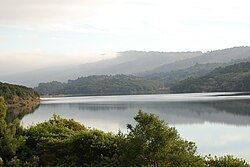
Crystal Springs Reservoir is a pair of artificial lakes located in the northern Santa Cruz Mountains of San Mateo County, California situated in the rift valley created by the San Andreas Fault just to the west of the cities of San Mateo and Hillsborough, and I-280. The lakes are part of the San Mateo Creek watershed.
Contents
- Map of Crystal Springs Reservoir California 94062 USA
- HistoryEdit
- DescriptionEdit
- Flora and faunaEdit
- References
Map of Crystal Springs Reservoir, California 94062, USA
HistoryEdit
The original name of the southern or Upper Crystal Springs Reservoir was Laguna Grande, which has a California Historical Marker ("NO. 94 PORTOLA EXPEDITION CAMP - The Portolà expedition of 1769 camped on November 5 at a 'laguna grande' which today is covered by the Upper Crystal Springs Lake.") located at Crystal Springs Dam on Skyline Boulevard, 0.1 mi south of Crystal Springs Road. The Laguna Grande place name is also shown on the 1840s diseño del Rancho Cañada de Raymundo and an 1856 plat of the Rancho de las Pulgas. Lower Crystal Springs Reservoir now covers the town of Crystal Springs which grew up around a little resort town of the same name, located just northwest of the present dam.
The two Crystal Springs lakes and San Andreas Lake used to be known as Spring Valley Lakes for the Spring Valley Water Company which owned them. The Spring Valley Water Company named the lakes, the Spring Valley Lakes, after the company. The original Spring Valley was between Mason and Taylor Streets, and Washington and Broadway Streets in San Francisco, where the water company started. When the company went south for more water, the Spring Valley name was carried south too.
DescriptionEdit
The entire reservoir consists of two different reservoir lakes.
The southern lake, Upper Crystal Springs Reservoir, was formed when a tributary, Laguna Creek (or Lake Creek), which joined Laguna Grande at the south end, was submerged by construction of an earthen dam (this was the first Crystal Springs Dam) in 1877. The old earthen dam became a causeway between Upper and Lower Crystal Springs Reservoirs when the latter was formed by Herman Schussler's 150 foot tall concrete Crystal Springs Dam, which dammed up San Mateo Creek to form the lower (northern) reservoir in 1888. The causeway is now crossed by Highway 92. Laguna Creek flows north through the Filoli estate and has tributaries that descend from the western slope of Edgewood County Park and the eastern slope of the Santa Cruz Mountains. In addition to Laguna Creek, Upper Crystal Springs Reservoir is fed by Adobe Gulch which descends from Cahill Ridge south of and parallel to Highway 92 into a wetland marsh then joins the reservoir at Adobe Point.
The northern reservoir, Lower Crystal Springs Reservoir, is fed by San Mateo Creek and San Andreas Creek at its north end. It also receives water from Upper Crystal Springs Reservoir via tunnels beneath Highway 92. Below Crystal Springs Dam, lower San Mateo Creek receives limited flows from Lower Crystal Springs Reservoir and descends to the Bay.
In 1924, culverts were built through Upper Crystal Springs Dam to hydraulically link Upper and Lower Crystal Springs Reservoirs.
Part of the water in the reservoirs comes from local precipitation and the rest is piped in from the Hetch Hetchy Reservoir in Yosemite National Park, as well as the Pilarcitos Creek watershed and Alameda Creek watershed. The entire reservoir was built and owned by a private company, in the form of the Spring Valley Water Company, and eventually was deeded under the ownership and protection of the city of San Francisco. This local protection has ensured the survival of important species in the area, and a set of trails in Crystal Springs Park allows many to enjoy the scenic beauty of the reservoir and the local wildlife. There are giant rainbow trout and bass in the lake. Due to decisions by the San Francisco Public Utilities Commission (SFPUC), Crystal Springs Reservoir is not open to public.
Flora and faunaEdit
A considerable biodiversity of flora and fauna exist in the vicinity of the reservoir, which is located within the California Floristic Province. Among these species are a number of rare and endangered species including Acanthomintha duttonii or San Mateo thornmint, Hesperolinon congestum (Marin Dwarf Flax) and Eriophyllum latilobum or San Mateo Woolly Sunflower.
A pair of Bald eagles (Haliaeetus leucocephalus) built a nest in a Coast Douglas-fir (Pseudotsuga menziesii var. menziesii) in March 2012. This is the first bald eagle nest in San Mateo County since 1915, almost 100 years ago. Although initially unsuccessful, they have returned to their nest in the northwest corner of the Lower Reservoir. In 2013, they successfully mated and the fledgling flew North after leaving the nest.