
Length 90.8 km | ||
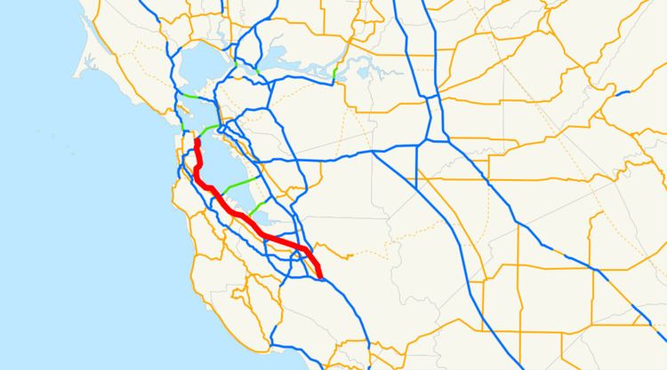 | ||
North end: US 101 / I-80 in San Francisco | ||
Highway 101 bayshore freeway san francisco california
The Bayshore Freeway is a part of U.S. Route 101 in the San Francisco Bay Area of the U.S. state of California. It runs along the west shore of the San Francisco Bay, connecting San Jose with San Francisco. Within the city of San Francisco, the freeway is also known as James Lick Freeway, named after the California philanthropist. The road was originally built as a surface road, the Bayshore Highway, and later upgraded to freeway standards. Before 1964, it was mostly marked as U.S. Route 101 Bypass, with US 101 using the present State Route 82 (El Camino Real).
Contents
- Highway 101 bayshore freeway san francisco california
- Map of Bayshore Fwy California USA
- Route description
- Initial construction
- Reconstruction
- Exit list
- References
Map of Bayshore Fwy, California, USA
Route description
The Bayshore Freeway begins at the Blossom Hill Road interchange on US 101, where SR 82 begins its northwesterly path along Monterey Highway to San Jose. The freeway curves north and northwest, bypassing downtown San Jose to the east, and then curves west-northwest, crossing I-880 and SR 87, the latter just north of the San Jose International Airport. The portion of the highway from San Jose to South San Francisco is relatively straight and flat, running near the west edge of the San Francisco Bay. Junctions here include SR 237 in Sunnyvale, SR 85 in Mountain View, SR 84 in Menlo Park and Redwood City, SR 92 in San Mateo, and the San Francisco International Airport and I-380 in San Bruno. In South San Francisco, the freeway curves northeast around San Bruno Mountain, crossing its east edge at Sierra Point, and then heads north on a causeway across the former Candlestick Cove to the San Francisco city line.
In San Francisco, where the road is also known as the James Lick Freeway, it continues north-northwesterly between Bayview Park and McLaren Park, and crosses I-280 at the Alemany Maze. There it curves north-northeasterly around Bernal Heights and then northwest around Potrero Hill, meeting the Central Freeway at the border between the Mission District and South of Market. The Bayshore Freeway ends at the intersection of US 101 and Interstate 80, which, although signed as Interstate 80, is not officially Interstate 80 until the San Francisco-Oakland Bay Bridge. The freeway that goes from US 101 to the Bay Bridge that is signed as I-80 but not officially I-80 is called the San Francisco Skyway.
Initial construction
Before the Dumbarton and San Mateo-Hayward Bridges were built across the San Francisco Bay in the 1920s, San Francisco was bottled up at the north end of a long peninsula, with driving south on El Camino Real towards San Jose as the only reasonable alternative to the ferries for crossing the bay. The first of several highways built as an alternate to El Camino Real was the Skyline Boulevard, which was added to the state highway system in 1919. A second route, the Bay Shore Highway (Route 68), became a state highway in 1923, but only from the San Francisco city limits into San Mateo County, where the Dumbarton Bridge would begin. Just prior to the start of construction on the Dumbarton Bridge, San Francisco Supervisor Richard J. Welch noted that the Bay Shore Highway would need to be built all the way to San Jose as an escape valve for the additional traffic that the bridge would attract.
The state legislature extended the highway in 1925, defining it to run from near the intersection of Army Street (Cesar Chavez Street) and San Bruno Avenue in San Francisco to a point in San Jose. The governor approved the bill with the stipulation that only the portion between the city limits of San Francisco and San Jose would be a state highway. Construction between South San Francisco and Burlingame had begun by 1924, funded by a $500,000 contribution from San Francisco, and was completed in 1928. A disconnected segment north of San Mateo was built by the state at the same time. It was not until February 1929 that the road was fully paved between San Francisco and Burlingame, and on October 20, 1929 the new highway was officially dedicated to San Mateo, several months after the connecting San Mateo-Hayward Bridge opened (at what is now Third Avenue). Even then, motorists had to wait until May 7, 1931 to reach Jefferson Avenue in Redwood City (near the west end of the four-year-old Dumbarton Bridge). The roadway was extended to Oregon Avenue in Palo Alto in mid-1932, Lawrence Station Road in mid-1933, and to Lafayette Street near Santa Clara, across the Guadalupe River from San Jose, by 1934. The final piece to Oakland Road (13th Street) in San Jose, which was then the main road - Legislative Route 5 and Sign Route 17 - between San Jose and Oakland, was dedicated on June 12, 1937, over ten years after the Dumbarton Bridge opened in January 1927.
Although the highway was designed and built to what were, at the time, high standards, with a 100-foot (30 m) wide right-of-way in most places, it was accident-prone because it lacked a median barrier. One segment of the so-called "Bloody Bayshore" was "Boneyard Hill", a steep grade through the Visitacion Valley near the San Francisco city line, running past a bone meal plant. Causes of the crashes included turning conflicts at intersections, and speeding drivers crossing the centerline to use the oncoming lanes as a passing lane. The roadway was entirely at-grade except for crossings of rail lines. It generally followed the present alignment of the Bayshore Freeway, but deviated in several places: Old Bayshore Highway in San Jose, Veterans Boulevard in Redwood City, Bayshore Highway in Burlingame, a destroyed section of road through San Francisco International Airport, and Airport and Bayshore Boulevards from South San Francisco through Brisbane into San Francisco. Within that city, the new highway continued three miles (5 km) along the present Bay Shore Boulevard to Army (Cesar Chavez) Street and Potrero Avenue.
When the Bayshore Highway was completed in 1937, U.S. Route 101 signs were moved to it from El Camino Real, and El Camino became U.S. Route 101 Alternate. Businesses along El Camino created the El Camino Real Association to protest the move and resulting loss of business, and by 1939 the main route had been moved back, with the Bayshore Highway becoming U.S. Route 101 Bypass. The two routes split in San Jose at the junction of First and Second Streets near Keyes Street, with the El Camino route mostly following the present SR 82 and the Bayshore route using locally maintained Second, Reed, and Fourth Streets to reach the state-maintained Bayshore Highway. In San Francisco, they rejoined at the present location of the Alemany Maze, with the El Camino route following Alemany Boulevard from near the city line; from there US 101 continued north on Bay Shore Boulevard, Potrero Avenue, and 10th and Fell Streets to Van Ness Avenue, meeting the Bay Bridge approach (US 40/US 50) at Bryant and Harrison Streets. The Bryant/Harrison one-way pair was added to Route 68 (which already included the bridge) in 1937 and removed in 1947 along with the bridge; in 1961 the new freeway approach became part of Route 68, which was extended back over the bridge to Route 5 at its Oakland landfall.
Construction of an extension to Route 115 (Santa Clara Street, now SR 130) at 30th Street in San Jose began in 1939, and was completed by late 1940. As with the portion between Fourth and 13th Streets, it was not marked as a numbered route. The state legislature authorized an extension beyond San Jose back to El Camino Real near Ford Road in 1947, which was already under construction, and was completed that year. This was the first segment built with interchanges, and included a median barrier. Despite this, most crossings were at-grade; only the two ends at Route 115 (Santa Clara Street) and regular US 101 included bridges, the former a diamond interchange and the latter a simple split with additional access to Ford Road. It also crossed over Coyote Road, though with no access, just south of the Coyote Creek bridge. The original 1947 bridge over Coyote Road remains, though widened in 1990, and is one of the oldest road-road grade separations on the present freeway.
Reconstruction
By 1940, at the dawn of the freeway era, the state was making plans to convert the Bayshore Highway into a ten-lane Bayshore Freeway between San Francisco and Palo Alto. The first piece built was from Peninsula Avenue at the San Mateo-Burlingame line to South San Francisco. This six-lane freeway, completed in 1949, followed the existing highway to Broadway in Burlingame, but then took a more inland alignment past the San Francisco International Airport, and crossed the old road at South San Francisco, running just east of it to near the south end of the cut at Sierra Point. Construction began inside San Francisco in 1950 and was completed in 1958; the new causeway across Candlestick Cove, connecting the completed section in South San Francisco with San Francisco, was dedicated in mid-1957. In 1951, the state legislature renamed the portion within San Francisco after James Lick, a California pioneer and philanthropist.
A movement to make the four-lane undivided "Bloody Bayshore" safer all the way to San Jose began in Palo Alto. As a temporary measure, the state lowered the speed limit, installed traffic signals, closed minor crossroads, and prohibited left turns in places. The community convinced the state to extend the six-lane freeway, which was completed in 1962. The freeway continued to end at the old El Camino Real merge near Ford Road until the early 1980s, when the South Valley Freeway was constructed.
Exit list
Except where prefixed with a letter, postmiles were measured on the road as it was in 1964, based on the alignment that existed at the time, and do not necessarily reflect current mileage. R reflects a realignment in the route since then, M indicates a second realignment, L refers an overlap due to a correction or change, and T indicates postmiles classified as temporary (for a full list of prefixes, see the list of postmile definitions). Segments that remain unconstructed or have been relinquished to local control may be omitted. The numbers reset at county lines; the start and end postmiles in each county are given in the county column.