
Formed September 8, 1993 Fatalities 6 direct, 1 indirect | Dissipated September 14, 1993 Damage $8 million (1993 USD) | |
 | ||
Highest winds 1-minute sustained: 150 mph (240 km/h) Lowest pressure 930 mbar (hPa); 27.46 inHg Date 8 September 1993 – 14 September 1993 Similar Hurricane Celia, Hurricane Fernanda, Hurricane Calvin, Hurricane Gert, Hurricane Hilary (1993) | ||
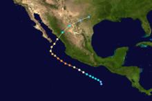
Hurricane Lidia was the strongest tropical cyclone of the 1993 Pacific hurricane season. Forming from a tropical wave on September 8, Lidia steadily organized and became a hurricane on September 10. The hurricane continued to strengthen while developing a well-defined eye, and peaked as a Category 4 hurricane on September 11. However, it weakened considerably before making landfall in Sinaloa as a Category 2 storm. Lidia dissipated near Austin on September 14 and was later absorbed by a cold front. Across Mexico, the hurricane killed seven people; over 100,000 people were forced to evacuate their homes. A total of 160 homes were destroyed and 10,000 people were left homeless because of the storm. In the United States, five people suffered injuries and storm damage totaled $8 million (1993 USD).
Contents
Meteorological history
A westward-moving tropical wave left the coast of Africa on August 24. Initially, shower activity was minimal, but it increased somewhat as it approached the southern Lesser Antilles. Disorganized, the wave moved through the Southwestern Caribbean Sea on September 3 and 4. The system quickly emerged into the Pacific Ocean, to the south of Central America. After September 7, shower activity began to increase and the cloud pattern became more organized. At this time, the disturbance was located about 200 mi (320 km) south of Salina Cruz. After becoming much better organized, it developed well-defined banding features and a well-defined atmospheric circulation. Based on this, the disturbance was upgraded into a tropical depression later that day. It continued to organize, and a nearby ship later reported near gale-force winds far from its center. Based on this, the depression was upgraded into Tropical Storm Lidia overnight.
Meanwhile, Lidia was moving to the northwest at around 10 mph (15 km/h). On 0000 UTC September 9, the tropical storm attained winds of 45 mph (75 km/h) while located about 300 mi (480 km) south-southwest of Salina Cruz. After pausing in intensification for a while, Lidia resumed intensification later that day. Predicted to peak as a Category 2 hurricane on the Saffir–Simpson hurricane wind scale (SSHWS), the system developed very deep convection and a well-defined outflow. Shortly thereafter, the National Hurricane Center (NHC) upgraded Lidia into a hurricane. Although Hurricane Lidia was expected to parallel the Pacific Coast of Mexico, the agency did note that Lidia could pose a threat to parts of the country. Late on September 9, Hurricane Lidia finally developed an eye, and thus the NHC re-assessed the intensity at 90 mph (150 km/h). Over the next six hours, a wind increase of 15 mph (25 km/h) occurred, and the hurricane reached major hurricane intensity (Category 3 or higher on the SSHS). Lidia was now predicted to threaten the Baja California Peninsula. At 1200 UTC on September 11, Hurricane Lidia reached its peak wind speed of 150 mph (240 km/h) as the hurricane developed a clear and distinct eye.
Thunderstorm activity near the eye soon decreased in coverage, and Lidia began a weakening trend. Because of two troughs, one over the northern Gulf of California and another over the Southwestern United States, the weakening system began to re-curve northeast. Heading towards mainland Mexico, the hurricane weakened significantly a day after its peak, in which Lidia was only a mid-level Category 2 hurricane. Continuing to weaken, Lidia made landfall in Sinaloa at 1800 UTC on September 13. Shortly after landfall, Hurricane Lidia then accelerated northeastward and then east-northeastward. It weakened to a depression just after crossing the international border with Texas. Tropical Depression Lidia dissipated near Austin on September 14. The remnants of the cyclone were absorbed by a cold front.
Mexico
A tropical storm warning was issued from Acapulco to Cabo Corrientes at 2100 UTC September 21, but was discontinued 18 hours later. On 0300 UTC September 12 a hurricane warning was issued for areas below La Paz. Twelve hours later, a tropical storm warning was issued for the remaining portion of Baja California Sur. The same day, a hurricane warning was issued for a large area of the mainland. However, all watches and warnings were discontinued on September 13 as the system had moved inland over Mexico.
Although no reports of tropical storm force winds over land were received by the NHC, it is estimated that near-hurricane-force winds occurred near Mazatlán. The following locations received more than 8 in (200 mm) of rain; 12.72 in (323 mm) fell in La Cruz/Elota, 12.3 inches (310 mm) fell in Ayolta, 8.7 in (220 mm) fell in La Cruz, and 8.3 in (210 mm) was recorded in Digue La Primeva. Seven deaths are fully attributed to the storm and 41 people perished in combination of Tropical Storm Beatriz, Hurricane Gert, and Lidia. In addition, one injury were reported. One person in Sinaloa was electrocuted, and another person died in Durango during the collapse of a dwelling. Three fishing boats were reported missing at sea. More than 10,000 people were homeless, and damage was widespread in both of the states. Hundreds of shanty-homes near Mazatlán were toppled, and 100 houses were destroyed in La Cruz. In Durango, 16 homes were destroyed and 4,000 were damaged. In some areas of Nayarit, flooding destroyed several areas of agriculture. Near Culiacán, 1,200 head of cattle were killed, and a 150-foot (46 m) television tower was blown over. Utility poles, snapped trees and branches, and shredded billboards littered strreets. Water, telephone, and electricity were cut off. Due to lack of power, gas stationss were unable to pump. Many windows were smashed and widespread power and cell phone service outages were recorded. However, the hurricane avoided the more populated areas of the country, thus greatly reducing damage. About 100,000 people were forced to evacuate their homes. During the aftermath of the storm, army troops provided blankets and food to the homeless.
United States
The remnants of Lidia, in combination of a cold front, prompted a tornado watch and flash flood watch for much of Texas. In Texas, six tornadoes were reported, with one of them causing over $8 million (1993 USD) in damage. The Dallas-Fort Worth area was hit hard. Strong winds, tornadoes and torrential downpours left broken trees, damaged buildings, and minor injuries in the wake of the storm. Johnson, Denton, Collin, Tarrant, and Dallas counties were the hardest hit. In northern Arlington, five people were injured when a roof was torn off of a hotel.