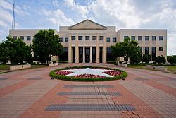
Website www.co.denton.tx.us Founded 1846 Population 728,799 (2013) | Area 2,468 km² County seat Denton | |
 | ||
Colleges and Universities University of North Texas, Texas Woman's University, National American University, Regency Beauty Institute Destinations | ||
Denton County is a county in the U.S. state of Texas. As of the 2010 census, its population was 662,614, making it the ninth-most populous county in Texas. The county seat is Denton. The county, which was named for John B. Denton, was established in 1846.
Contents
- Map of Denton County TX USA
- History
- Lakes
- Adjacent counties
- Demographics
- Politics
- Education
- Transportation
- Major Highways
- Census designated places
- Unincorporated community
- Ghost Town
- Notable People
- References
Map of Denton County, TX, USA
Denton County is included in the Dallas-Fort Worth-Arlington, TX Metropolitan Statistical Area. In 2007, it was one of the fastest-growing counties in the United States.
History
Before the arrival of white settlers, various Native American peoples, including the Kichai and the Lenape, infrequently populated the area. The area was settled by Peters Colony landowners in the early 1840s. Until the annexation of Texas, the area was considered part of Fannin County. On April 11, 1846, the First Texas Legislature established Denton County. The county was named for John B. Denton, who was killed while raiding a Native American village in Tarrant County in 1841. Originally, the county seat was set at Pickneyville. This was later changed to Alton, where the Old Alton Bridge currently stands, and then moved finally to Denton.
By 1860, the population of the county had increased to 5,031. On March 4, 1861, residents of the county narrowly voted for secession from the Union, with 331 votes cast for and 264 against. The Missouri–Kansas–Texas Railroad reached Lewisville, located in the southern portion of the county, by the early 1880s. The Denton County Courthouse-on-the-Square was built in 1896, and today the building currently houses various government offices as well as a museum.
Lakes
According to the U.S. Census Bureau, the county has a total area of 953 square miles (2,470 km2), of which 878 square miles (2,270 km2) is land and 75 square miles (190 km2) (7.8%) is water. Denton County is located in the northern part of the Dallas-Fort Worth metroplex, approximately 35 miles south of the border between Texas and Oklahoma. It is drained by two forks of the Trinity River. The largest body of water in Denton County is Lewisville Lake, which was formed in 1954 when the Garza–Little Elm Reservoir was merged with Lake Dallas. The county is on the western edge of the Eastern Cross Timbers and also encompasses parts of the Grand Prairie portion of the Texas blackland prairies. Portions of Denton County sit atop the Barnett Shale, a geological formation believed to contain large quantities of natural shale gas. Between 1995 and 2007, the number of natural gas wells in the county increased from 156 to 1,820, which has led to some controversy over the pollution resulting from hydraulic fracturing.
Adjacent counties
Demographics
As of the 2010 United States Census, there were 662,614 people, 224,840 households and 256,139 housing units in the county. The population density was 754.3 people per square mile. The racial makeup of the county was 75% White, 8.4% Black or African American, 0.7% Native American, 6.6% Asian, 0.1% Pacific Islander, and 2.9% from two or more races. 18.2% of the population were of Hispanic or Latino origin. Denton County ranked twenty-ninth on the US Census Bureau's list of fastest-growing counties between 2000 and 2007, with a 41.4% increase in population.
A Williams Institute analysis of 2010 census data found there were about 5.2 same-sex couples per 1,000 households in the county.
Politics
Denton County, like most suburban counties in Texas, votes reliably for Republican candidates in statewide and national elections. The last Democratic presidential candidate to win the county was Lyndon Johnson in 1964.
Education
The following school districts lie entirely within Denton County:
The following school districts lie partly within Denton County:
The following private educational institutions serve Denton County:
The following higher education institutions serve Denton County:
Transportation
The Denton County Transportation Authority (DCTA) operates a bus service in the county that includes Denton, Lewisville, and Highland Village. SPAN Transit covers areas outside of Denton and Lewisville.
DCTA also operates the A-train, a commuter rail service runs from Denton to Carrollton, at which station passengers can switch to the Green Line train owned and operated by Dallas Area Rapid Transit (DART). Passengers can transfer to other DART lines (denominated by different colors) at the downtown Dallas DART station.
The county is home to the Denton Municipal Airport and the Northwest Regional Airport in Roanoke. Dallas/Fort Worth International Airport is located a few miles south of the county.
