
Country United States Population 26,148 (2010) | Zip code 11414 | |
 | ||
State vte State of New YorkAlbany (capital)TopicsBibliographyDemographicsEconomyEducationGeographyHistoryHealthcareMuseumsMusicNicknameParksPeoplePoliticsSportsSymbolsTransportationTourist attractionsPoliticsAdministrative divisionsCongressional districtsConstitutionElectionsGovernmentLawRegionsAdirondack MountainsAllegheny PlateauCapital DistrictCatskill MountainsCentral Region (formerly Central-Leatherstocking)Central New YorkChamplain ValleyNew York CityFinger LakesHolland PurchaseHudson HighlandsHudson ValleyLong IslandMohawk ValleyNiagara FrontierNorth CountryRidge and ValleySaint Lawrence SeawayShawangunksSki countrySouthern TierSouthtownsTech ValleyThousand IslandsTug HillUpstateWesternMetro areasAlbany / Schenectady / TroyBinghamtonBuffalo / Niagara FallsElmira / CorningGlens FallsIthacaKingstonNew York CityRochesterSyracuseUtica / RomeWatertownCountiesAlbanyAlleganyBronxBroomeCattaraugusCayugaChautauquaChemungChenangoClintonColumbiaCortlandDelawareDutchessErieEssexFranklinFultonGeneseeGreeneHamiltonHerkimerJeffersonKingsLewisLivingstonMadisonMonroeMontgomeryNassauNew YorkNiagaraOneidaOnondagaOntarioOrangeOrleansOswegoOtsegoPutnamQueensRensselaerRichmondRocklandSaint LawrenceSaratogaSchenectadySchoharieSchuylerSenecaSteubenSuffolkSullivanTiogaTompkinsUlsterWarrenWashingtonWayneWestchesterWyomingYatesPlacesCitiesTownsIndian reservationsVillagesCensus-designated places Topics BibliographyDemographicsEconomyEducationGeographyHistoryHealthcareMuseumsMusicNicknameParksPeoplePoliticsSportsSymbolsTransportationTourist attractions Politics Administrative divisionsCongressional districtsConstitutionElectionsGovernmentLaw Regions Adirondack MountainsAllegheny PlateauCapital DistrictCatskill MountainsCentral Region (formerly Central-Leatherstocking)Central New YorkChamplain ValleyNew York CityFinger LakesHolland PurchaseHudson HighlandsHudson ValleyLong IslandMohawk ValleyNiagara FrontierNorth CountryRidge and ValleySaint Lawrence SeawayShawangunksSki countrySouthern TierSouthtownsTech ValleyThousand IslandsTug HillUpstateWestern Metro areas Albany / Schenectady / TroyBinghamtonBuffalo / Niagara FallsElmira / CorningGlens FallsIthacaKingstonNew York CityRochesterSyracuseUtica / RomeWatertown Restaurants Matteo's Howard Beach, Brothers Ravioli, That's A Wrap, Prima Pasta & cafe, Gino's | ||
Howard Beach is an upper middle class neighborhood in the southwestern portion of the New York City borough of Queens. It is bordered in the north by the Belt Parkway and South Conduit Avenue in Ozone Park, in the south by Jamaica Bay in Broad Channel, in the east by 102nd–104th Streets, and in the west by 75th Street. The area's houses are similar to Bayside and Hollis.
Contents
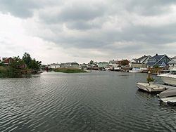
- Map of Howard Beach Queens NY USA
- String of brazen burglaries leaves howard beach queens on edge
- Early development
- Hate crimes
- Hurricane Sandy
- Demographics
- Geography
- Hamilton Beach
- Lindenwood
- Old Howard Beach
- Ramblersville
- Rockwood Park
- Government
- Transportation
- Schools
- Notable people
- In popular culture
- References
Map of Howard Beach, Queens, NY, USA
The neighborhood is part of Queens Community District 10, served by Queens Community Board 10. It is home to a large Italian-American population. The ZIP code of Howard Beach is 11414.
String of brazen burglaries leaves howard beach queens on edge
Early development
Howard Beach was established in 1897 by William J. Howard, a Brooklyn glove manufacturer who operated a 150-acre (0.61 km²) goat farm on meadow land near Aqueduct Racetrack as a source of skin for kidd gloves. In 1897, he bought more land and filled it in and the following year, built 18 cottages and opened a hotel near the water, which he operated until it was destroyed by fire in October 1907. He gradually bought more land and formed the Howard Estates Development Company in 1909. He dredged and filled the land until he was able to accumulate 500 acres (2 km²) by 1914. He laid out several streets, water mains and gas mains, and built 35 houses that were priced in the $2,500–$5,000 range.
The Long Island Rail Road established a station named Ramblersville in 1905 and a Post Office by the same name opened soon thereafter. A casino, beach, and fishing pier were added in 1915 and the name of the neighborhood was changed to Howard Beach on April 6, 1916. Development continued and ownership was expanded to a group of investors who sold lots for about $690 each starting in 1922. Development, however, was limited to the areas east of Cross Bay Boulevard near the LIRR station now known as Bernard Coleman Memorial Square (then Lilly Place). The rest of Howard Beach consisted of empty marsh land except for the area to the south of Coleman Square, centered around Russell St. and 102nd St., which consisted of many small fishing bungalows that dotted alongside Hawtree Creek and Jamaica Bay. This area of Howard Beach would retain the name "Ramblersville." Despite its close proximity to the Howard Beach station at Coleman Square, the LIRR would establish a station a quarter of a mile south down the line at Hamilton Beach in 1919.
After World War II, Queens and Long Island went through a major suburban building boom leading to the marsh land west of Cross Bay Boulevard to be filled in. This led to the development of many Cape-Cod and High-Ranch style houses on 50 and 60 x 100 lots. This area was developed as "Rockwood Park" to the north and "Spring Park" to the south, together comprising what would be known as "New Howard Beach", while the area east of the boulevard became known as "Old Howard Beach." In the early 1950s, farm land north of Rockwood Park was developed with the building of many red bricked two-story garden style cooperative apartments along with some six-story co-op and condo apartment buildings. A number of private two-family houses were also built in this neighborhood, which was named Lindenwood. The various neighborhoods continued to be developed through the 1960s and 1970s as Cross Bay Boulevard became the area's main shopping district. During the 1990s and 2000s, there was further high-scale development as many of the area's old houses were torn down and replaced with upscale million-dollar mini-mansions.
Hate crimes
In 1986 and 2005, Howard Beach experienced two well-publicized hate crime incidents.
On December 20, 1986, one African-American man was killed and another was beaten in Howard Beach, in a racially charged incident that heightened racial tensions in New York City. The dead man was 23-year-old Michael Griffith, a Trinidadian native living in Bedford-Stuyvesant, Brooklyn. He was killed after being almost accidentally hit by a car with three teenagers inside it on December 20, 1986. Griffith was chased onto a highway by a mob of white youths who had beaten him and his friends. Griffith's death was the second in a string of three racially motivated killings of blacks by white mobs in New York City in the 1980s.
On June 29, 2005 three African-Americans were attacked with baseball bats by local white men as they were attempting to steal a car from the area. One of them was injured seriously enough to be hospitalized and two arrests were made in the case. The convicted assailant, Nicholas Minucci, claimed that the victims had attempted to rob him. On June 10, 2006, Minucci, 20, who uttered a racial epithet during the baseball bat attack, was found guilty of robbery and the racially motivated assault of Glenn Moore. On July 17, 2006, Minucci was sentenced to 15 years in prison.
Hurricane Sandy
In 2012, Hurricane Sandy struck; it had a devastating effect on much of the neighborhood. Howard Beach was one of the many seaside city neighborhoods that was hit by Hurricane Sandy's record storm surge. On October 28, 2012 city officials ordered a mandatory evacuation of all Zone A neighborhoods (low-lying neighborhoods susceptible to storm surge), in the city, this included the Howard Beach neighborhood of Hamilton Beach. However, most of the rest of Howard Beach lay in Zone B which was only ordered with a voluntary evacuation. Many neighborhood residents decided to stay and ride out the storm citing the relatively minor damage caused the previous year by Hurricane Irene. Nevertheless, when Sandy made landfall on October 29 a ten-foot-high storm surge from Jamaica Bay flooded all of Old and New Howard Beach as well as the neighborhoods of Broad Channel and the Rockaways in addition to some sections of Lindenwood and neighboring Ozone Park. Most, if not all, houses in the neighborhood suffered some flooding damage as well as all stores along Cross Bay Blvd. The Howard Beach – JFK Airport station along with the IND Rockaway Line trestle carrying trains over Jamaica Bay into Broad Channel and the Rockaways were also heavily damaged. Power was out for over three weeks in the neighborhood. In the wake of Sandy, the Federal Emergency Management Agency and the New York City Office of Emergency Management have provisionally re-classified Howard Beach along with the Brooklyn neighborhoods of Gerritsen Beach and Red Hook as Zone A neighborhoods.
As of early 2013, recovery in the neighborhood has been largely successful yet still ongoing. On April 5, 2013, the Howard Beach post office reopened after extensive repairs. Residents are still working to recover from Sandy's aftereffects.
Demographics
As of the 2000 census, there were 28,121 people residing in Howard Beach. The racial makeup of the neighborhood was 85.9% Non-Hispanic White, 2.8% Asian, 0.0% Pacific Islander, 1.0% African American, 2.3% from other races, and 1.2% from two or more races. 11.8% of the population were Hispanic or Latino of any race. 13.1% of the population is foreign-born. The estimated median household income as of 2007 is $69,800. Many of the residents are Italian-American, often from immigrant families that relocated from Brooklyn in the 1940s and 1950s as they looked for a better life for their families.
Geography
Like many New York City neighborhoods, Howard Beach is composed of several smaller neighborhoods – Howard Beach, Old Howard Beach, Hamilton Beach, Ramblersville, Spring Park, Rockwood Park, Lindenwood, and Howard Park (Old Howard Beach, Ramblersville, Howard Park, and Hamilton Beach are sometimes all grouped together as "Old Howard Beach", instead of being referred to by their proper names). Howard Beach proper is a small peninsula bordered by the Belt Parkway and Conduit Avenue on the north, Jamaica Bay on the south, Hawtree Creek on the east separating it from Hamilton Beach and Shellbank Basin on the west that separates it from Cross Bay Boulevard.
Cross Bay Boulevard is the main commercial strip of Howard Beach and going northward it eventually turns into Woodhaven Boulevard after Ozone Park. Throughout the 1970s and 80s, the Boulevard was made up almost exclusively of locally owned shops and restaurants. However, starting in the 1990s, chain stores and restaurants began moving in and now many well-known franchises are on the boulevard. Entertainment venues on Cross Bay Boulevard such as the Kiddie-Park and Cross-Bay Lanes were popular until their collapse in the 1970s and 1980s. The Joseph P. Addabbo Memorial Bridge (named for a deceased member of the United States House of Representatives who once represented the district that includes Howard Beach) carries the boulevard over Jamaica Bay, connecting mainland Queens to Broad Channel.
Bernard Coleman Memorial Square (colloquially known as Coleman Square) is a small plaza near the Howard Beach – JFK Airport station. There is a memorial to servicemen from Howard Beach who died in World War I, World War II, the Korean War, and the Vietnam War.
Hamilton Beach
Hamilton Beach is a middle class neighborhood in the New York City borough of Queens. Its boundaries are the 102nd Street Creek to the north, the IND Rockaway Line (A train) tracks and JFK Airport to the east, Hawtree Creek to the west, and Jamaica Bay to the south. Hamilton Beach is one of the few communities in New York City that has its own volunteer fire department. Hamilton Beach is frequently referred to as West Hamilton Beach. East Hamilton Beach was on the east side of the then Long Island Rail Road tracks, but was taken by the City for expansion of Idlewild Airport (now JFK Airport) in the 1940s. Hamilton Beach bears no relation to the Hamilton Beach Company other than the name. The company is named after a Mr. Hamilton and a Mr. Beach.
There was a Hamilton Beach station on the Long Island Rail Road's Rockaway Beach Branch. The station closed on June 27, 1955 in connection with the LIRR's sale of much of the branch's right of way to the New York City Transit Authority. Hamilton Beach is a small community that has one long strip (104th Street) with ten dead-end blocks connected to it. It is mostly surrounded by water. There is one way into Hamilton Beach by car and two ways in by foot. It is accessible by a boardwalk that stretches from the A train station at Coleman Square to 104th Street, or by the Hawtree Basin pedestrian bridge that is in between two of the ten blocks. This bridge connects Hamilton and Old Howard Beach. Hamilton has a small park at the southern end, with a 200-foot baseball field, a handball court, a small jungle gym area and beach. Gateways Hamilton Beach Park, just south of 165th Avenue, is the last stop for the Q11 bus. Hamilton Beach was once an area with dirt roads, old shack-type houses (bungalows), and no sewer system, as the area was unincorporated, but recently Hamilton Beach has been "building up." There are new houses going up on almost every block.
Lindenwood
Lindenwood is a section of Howard Beach, developed in the 1950s and 1960s, and sits on landfilled land. The neighborhood is part of Queens Community District 10, served by Queens Community Board 10. It is primarily made up of six-story, orange or red-brick apartment buildings, constructed in the early to mid-1960s, smaller co-op "garden-apartments" (four-unit red-brick buildings) constructed in the 1950s, and seen from the Belt Parkway, and two-family homes (some attached) built in the 1960s. The "hi-rise" apartment buildings are co-op (red bricks) or condominiums (orange brick). Heritage House East and West (84-39 and 84-29 153rd Avenue) were among the first condominium apartment buildings in New York State. Additional townhouses, near the Brooklyn border, were built in the 1970s, 1990s and 2000s. The hi-risers, used to be very family friendly but today many of the apartment building play grounds have been converted into sitting areas and no longer even allow dogs. Lindenwood's residents tend to be of mostly Jewish and Italian heritage along with some of Hispanic heritage.
In the middle of the neighborhood is the elementary school, P.S. 232, built in the early 1960s (and now known as the Walter Ward School, named after the neighborhood's late longtime City councilman) and the Lindenwood Shopping Center, which consists of a supermarket and about 20 stores. In the early 1970s, a second supermarket called the Village was located behind the shopping center. After failing, the building became a mall, flea market, bingo hall and private school before finally becoming a walk-in medical center. There is also a second small strip mall on Linden Boulevard, adjacent to the Lindenwood Diner.
Lindenwood once had a synagogue named Temple Judea. It was located on 153rd Ave and 80th Street, was converted into apartments when the temple merged with the then Howard Beach Jewish Center in Rockwood Park. The neighborhood also used to have two pool clubs, one on 88th Street and 151st Ave, that became walk-up apartments in the early 1970s and another across from 232 that was developed in 1980, into townhouses, adjacent to a branch of Queens County Savings Bank (formerly Columbia Savings Bank), which had been previously developed. There also used to be a tennis "bubble" on 153rd Ave and 79th Street, that was also developed around 1980.
Old Howard Beach
Old Howard Beach is a section of Howard Beach that lies between Shellbank Basin and Hawtree Creek to the east of Cross Bay Boulevard. Coleman Square, Wetzel Triangle and Frank M. Charles Park are located in Old Howard Beach. The area is locally referred to as "Old Howard Beach} since it was the original place in which founder William Howard built his famous hotel, and later the area's first houses in the 1920s. The current housing in Old Howard Beach consists of several different types of houses. Those located near the former Howard Park hospital are mainly 1950s and 1960s detached two-family homes, while the areas near Coleman Square, Frank M. Charles Park, and Shellbank Basin contain primarily single-family homes. The Q11 serves the neighborhood.
Ramblersville
Ramblersville is a section of greater Howard Beach, being a small neighborhood of about a dozen blocks between Hawtree Creek and JFK Airport. It is nearly surrounded by waterways leading into nearby Jamaica Bay. It is bordered by on the north by 160th Avenue, on the west by Hawtree Creek, across which is Old Howard Beach; on the east by the New York City Subway's Rockaway Line (A train, beyond which is Bergen Basin and the airport; and on the south by the 102nd Street Creek. Crossing the creek, 102nd Street reaches Hamilton Beach at Russell Street. The size of the neighborhood is about 1,000 feet (300 m) on each side, and it notably lacks the rectangular street grid of the surrounding neighborhoods.
Ramblersville, which once considered itself independent of New York City when the city was first unified, is purportedly the oldest neighborhood in what later became known as Howard Beach.
A 1905 article from The Washington Post said that all the houses were built on stilts and the population was one-thousand in the summer and a dozen in the winter. In 1962, the neighborhood's private water mains were replaced by the city; the neighborhood had 130 families at the time.
In 2001, The New York Times reported that the neighborhood "resembles a cozy fishing village with its pebbled streets and wooden bungalows built on pilings... [T]all grass... surrounds many of its marshy fields."
Fishing was a large industry in the tiny neighborhood. Ramblersville still has streets named Broadway, Church, and Bridge. Just north of Ramblersville is 159th Drive, also known as Remsen Place, named after Jeromus Remsen, a Revolutionary War officer. This area, near the current subway station, was known as "Remsen's Landing" at the time. Before the Howard Beach development was named in 1916, the entire area was commonly known as "Ramblersville", including Hamilton Beach to the south on Jamaica Bay, and Old Howard Beach to the west. The Howard Beach – JFK Airport subway stop was originally the "Ramblersville Station" on the Long Island Rail Road.
Ramblersville is the smallest neighborhood in New York City in terms of real estate per square foot.
Rockwood Park
Rockwood Park is a section of Howard Beach that mainly consists of single family homes and is considered to be a more upper class section of Howard Beach. It is part of what is commonly referred to as "New Howard" by many residents. The area is situated between 78th and 92nd Streets (these are north-south streets) and 156th and 165th Avenues (the east-west streets). The Q41 and Q21 serve Rockwood Park. To the west of 78th Street, the last street in the neighborhood, lies the Jamaica Bay Wildlife Refuge in which lies the border between Brooklyn and Queens.
The area remained primarily undeveloped during the first half of the 1900s. After the Second World War marsh land west of Cross Bay Boulevard was filled in, which led to the building of many Cape Cod-style houses in the area, followed later on in the 1960s and 1970s by high ranch-style houses. Becoming known as a more upscale section of Howard Beach led the area to become the home of many known mob figures, most notably Gambino crime family boss John Gotti who lived on 85th Street. Starting in the late 1980s and through the 2000s, Rockwood Park began to go through another building boom. Many of the area's old Cape Cod-style houses were demolished and replaced with upscale million dollar mini-mansions. Another famous resident was folk singer Woody Guthrie, who lived at 159-13 85th Street with his family after moving from Coney Island.
Government
Joseph Addabbo, Jr., the son of former Congressman Joseph P. Addabbo, represents the area as member of the New York State Senate. Congressman Gregory W. Meeks (D-NY) represents that part of Howard Beach east of 104th Street and Congressman Hakeem Jeffries (D-NY) represents the part west of 104th Street. Eric Ulrich (R-NY) is the New York City Councilman for Howard Beach. Stacey Pheffer Amato (D-NY) represents Howard Beach in the New York State Assembly.
Transportation
Howard Beach – JFK Airport on the IND Rockaway Line was formerly a Long Island Rail Road station on the Rockaway Beach Branch. Frequent fires on the trestle to Broad Channel forced the LIRR to file Chapter 11 bankruptcy protection in the 1950s, which allowed New York City Transit to purchase the line in 1956. The station provides a connection between the A train and Howard Beach JFK AirTrain route (and was, until 1990, the terminus of the former JFK Express, known colloquially as the "Train to the Plane"). Prior to the AirTrain JFK, the Port Authority provided a free shuttle bus to the terminals at JFK Airport. The AirTrain now provides these connections.
Local bus service in the neighborhood is provided on the Q11, Q21, Q41, Q52, Q53. All of these routes are operated by MTA Bus Company. There are also the QM15, QM16, QM17, QM18 express buses.
Schools
For grades 9–12, most residents attend John Adams High School or Robert H. Goddard High School in nearby Ozone Park, specialty high schools such as Beach Channel High School in Rockaway Park, or Catholic high schools such as Christ the King, St. Francis Prep, or Archbishop Molloy and Forest Hills High School.
Notable people
Notable current and former residents of Howard Beach include: