
County Kings County Length 3 km Listed 3 April 2010 Proposed 4 September 2009 | CERCLIS ID NYN000206222 Country United States of America | |
 | ||
Contaminants PAHs, VOCs, PCBs, pesticides, metals Similar Prospect Park, New York Harbor, Jamaica Bay, Smith–Ninth Streets, Brooklyn Bridge Park | ||
Dolphin trapped in the gowanus canal song a day 1485
The Gowanus Canal is a canal in the New York City borough of Brooklyn, on the westernmost portion of Long Island. Connected to Gowanus Bay in Upper New York Bay, the canal borders the neighborhoods of Red Hook, Carroll Gardens, and Gowanus, all within South Brooklyn, to the west; Park Slope to the east; Boerum Hill and Cobble Hill to the north; and Sunset Park to the south. It is 1.8 miles (2.9 km) long. There are seven bridges over the canal, carrying Union Street, Carroll Street (a landmark), Third Street, Ninth Street, Hamilton Avenue, the Gowanus Expressway, and the IND Culver Line of the New York City Subway.
Contents
- Dolphin trapped in the gowanus canal song a day 1485
- Map of Gowanus Canal Brooklyn NY USA
- Mill Creek
- Farms and oyster fishing
- Transformation to city
- Industrial heyday and massive pollution
- Economic decline
- Calls for revitalization
- Redevelopment plans
- Cleanup planning
- EPA treatment
- Reactivation of the Flushing Tunnel
- Stormwater management
- Current usage
- Activism
- Changes in water quality
- Anecdotal descriptions
- Scientific measurements
- Wildlife
- New forms of life
- In popular culture
- References
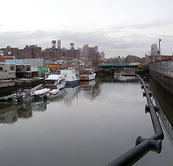
Map of Gowanus Canal, Brooklyn, NY, USA
Once a busy cargo transportation hub, the canal is now recognized as one of the most polluted bodies of water in the United States, and is a Superfund site. The canal's history has paralleled the decline of domestic shipping via water. The canal is still used for waterborne transportation of goods, notably fuel oil, scrap metal and aggregates. Tugs and barges still navigate the canal daily. A legacy of serious environmental problems has beset the area from the time the canal arose from the local tidal wetlands and fresh water streams. In recent years, there has been a call once again for environmental cleanup. In addition, development pressures have brought speculation that the wetlands of the Gowanus should serve waterfront economic development needs which may not be compatible with environmental restoration.
Mill Creek
The Gowanus neighborhood originally surrounded Gowanus Creek, which consisted of a tidal inlet of navigable creeks in original saltwater marshland and meadows that contained wildlife. Henry Hudson and Giovanni da Verrazzano both navigated the inlet in their explorations of New York Harbor. The first land patents within Breukelen (Brooklyn), including the land of the Gowanus, were issued by the Dutch Government from 1630 to 1664. In 1636, the leaders of New Netherland bought the area around the Gowanus Bay, and in 1639, the inhabitants swapped land claims with each other in order to build a tobacco plantation. The early settlers of the area named the waterway "Gowanes Creek" after Gouwane, sachem of the local Lenape tribe called the Canarsee, who farmed on the shores.
Adam Brouwer, who had been a soldier in the service of the Dutch West India Company, built and operated the first gristmill patented in New York at Gowanus (on land patented July 8, 1645, to Jan Evertse Bout). The tide-water gristmill on the Gowanus was the first in the town of Breukelen and was the first mill ever operated in New Netherland (located north of Union Street, west of Nevins Street, and next to Bond Street). A second mill (Denton's Mill, also called Yellow mill) was built on Denton's mill pond, after being granted permission to dredge from the creek to the mill pond once located between Fifth Ave and the present day canal at Carroll and Third Street. On May 26, 1664, several Breuckelen residents, headed by Brouwer, petitioned director general Peter Stuyvesant and his Council for permission to dredge a canal at their own expense through the land of Frederick Lubbertsen in order to supply water to run the mill. The petition was presented to the council on May 29, 1664, and the motion was granted. Another mill, Cole's Mill, was located just about at present day 9th Street, between Smith Street and the Canal. Cole's Mill Pond, located north of 9th street, occupied the present location of Public Place.
Farms and oyster fishing
In 1700, a settler, Nicholas Vechte, built a farmhouse of brick and stone now known as the Old Stone House. In 1776, during the Battle of Long Island, American troops engaged British Army troops at the house, enabling General George Washington to relocate his troops behind American lines. This house sat at the southeastern edge of the Denton's Mill pond. Brower's Mill (also known as Freeks Mill, located at the present day intersection of Union and Nevins streets) can be seen in drawings depicting the "Battle of Brooklyn."
Throughout this period, a few Dutch farmers settled along the marshland and engaged in clamming of large oysters that became a notable first export to Europe. The Gowanus Bay's 6-foot (1.8 m) tides pushed brackish water further into the creek, creating an environment in which large bivalves thrived; in succeeding generations, negative artificial selection slowly reduced the size of the bivalves.
Transformation to city
By the mid-19th century, the City of Brooklyn was quickly growing and already constituted the United States' third-largest city. The creek and surrounding agricultural land was now a part of an urban agglomeration, consisting of villages along the creek's shores. That same shoreline of river and swamp functioned as both a transportation system and an informal sewage system for the growing city. The valley's watershed is approximately six miles square and includes drainage from what are now the adjacent neighborhoods of Carroll Gardens and Park Slope. Wealthier residents tended to live inland and uphill to avoid the smells and "discomforts" of lower areas. Industries which needed water for processing, transport, and disposal of wastes, tended to locate along the shoreline.
The mills on the Gowanus were home to public landing sites, connecting the water route to the old Gowanus road. As the local population grew and 19th-century industrial revolution reached Brooklyn, the need for larger navigational and docking facilities grew. Colonel Daniel Richards, a successful local merchant, advocated the building of a canal to benefit existing inland industries and drain the surrounding marshes for land reclamation that would raise property values.
In 1849, under a decree by the New York Legislature, the Gowanus Creek was deepened so that it could be used as a 1.5-mile (2.4 km) commercial waterway connected to Upper New York Bay. The dredging of Gowanus Creek was completed in 1860. Another act of the legislature in 1867 allowed the canal to be deepened further. At the time the 1.8-mile-long (2.9 km), 100-foot-wide (30 m) canal was built, several designs were proposed for it, some with lock systems that would have allowed daily flushing of the whole waterway. However, these designs were considered too expensive. After exploring numerous alternative (and some more environmentally sound) designs, the final plan was chosen for its low price tag. United States Army Corps of Engineers (USACE) Major David Bates Douglass was hired to design the canal, which was essentially complete by 1869. The cost of the construction came from assessments on the local residents of Brooklyn and State money. However, this soon backfired, as the canal was constructed with significant design flaws.
Industrial heyday and massive pollution
Despite its relatively short length, the Gowanus Canal was a hub for Brooklyn's maritime and commercial shipping activity. At its busiest, as many as 100 ships a day transported cargo through the canal. In addition, the industrial sector around the canal grew substantially over time to include stone and coal yards; flour mills; cement works, and manufactured gas plants; tanneries, factories for paint, ink, and soap; machine shops; chemical plants; and sulfur producers, all of which emitted substantial water and airborne pollutants. Chemical fertilizers were manufactured along the canal soon after the Civil War. Coal processing was a dominant industry along the Gowanus Canal since 1869. Coal plants along the upper canal used large amounts of water in the conversion of coal to coke, liquids and gases. Coal gas was soon used for heating, light, and factory power. Coke was used to make steel. Wastewater and coal tar (now known to be a source of carcinogens) were dumped back into the canal. Brooklyn's slaughterhouses dumped blood and other wastes in the canals.
There was no through-flow of water and the canal was open at only one end, in the hope that the tides would be enough to flush the waterway. But with the canal's wooden and concrete embankments, the strong tides of fresh diurnal doses of oxygenated water from New York Harbor were barred from flowing into the channel. With the high level of development in the Gowanus watershed area, excessive nitrates and pathogens are constantly flowing into the canal, further depleting the oxygen and creating breeding grounds for the pathogens responsible for the canal's odor. Water quality measures of the concentration of oxygen in the canal were just 1.5 ppm, well below the minimum 4 ppm needed to sustain life. The canal water took on a reddish-purple color, and a colloidal mixture described as "black mayonnaise" accumulated at the bottom of the canal. In 1887, the New York State Legislature closed the Bond Street outflow point.
The first step to ameliorate pollution in the canal was the construction in the 1890s of the Bond Street sewer pipeline that carried sewage out into the harbor, but this proved inadequate. In the first attempt to improve flow at the northern, closed end of the canal, the "Big Sewer" was constructed from Marcy Avenue in Prospect Heights to Green and 4th Avenues in Gowanus, and then entering the canal at an inflow point near Butler Street. This sewer design was featured in Scientific American for its innovative construction method and size. The area this sewer ran through was known as "The Flooded District," and it was believed that this new sewer would serve two purposes: to drain the flooded district, and to use the flow of that excessive water to move the water of the upper Gowanus Canal. The tunnel was almost ready by 1892. The Brooklyn Daily Eagle initially hailed the sewer's size and extent, and it was almost ready by 1892 but declared it an engineering blunder shortly after its construction. The Big Sewer still exists under the streets of Brooklyn today.
By the 1900s, up to 700 structures were erected in South Brooklyn every year. Thriving industry brought many new people to the area but important questions about wastewater sanitation had not been properly addressed to handle such growth. All the sewage from the new buildings drained downhill and into the Gowanus; since there was less open ground than previously, rainwater now went onto the roofs of the buildings and down into the canal. The building of new sewer connections only compounded the problem by discharging raw sewage from neighborhoods even farther away into the canal. Pollutants, storm runoff, and discharge from the sewage system combined to made the canal's malodor so disgusting that it was nicknamed "Lavender Lake." Compounding the problem, property owners in the area sued the city for damages related to the flooding issues that plagued the canal.
By 1910, complaints were being made about the water of canal being almost solid waste, which provoked the installation of a flushing tunnel that was 12 feet (3.7 m) across. The Butler Street Pumping Station, a Beaux-Arts structure at the canal's inland end, opened on June 21, 1911, with the new flushing tunnel connecting to the Pumping Station. The tunnel at first supplied clean water to the upper reaches of the canal through the brick-lined 1.2-mile (1.9 km) tunnel via Butler Street to Buttermilk Channel between Brooklyn and Governors Island. Unfortunately, this too failed. Aside from numerous operational glitches, a long series of problems and mistakes occurred throughout the 1960s, culminating when a city worker dropped a manhole cover that severely damaged a pump system already suffering from the effect of the corrosive salt water. The Clean Water Act of 1972 had not yet been passed, and the city, stretched for funds at the time, did nothing to address the issue. As a result of the unrepaired damage to the Flushing Tunnel, and the long stretch of economic recession, the waters of the canal lay stagnant and under-used for years.
There is an urban legend that the canal served as a dumping ground for the Mafia. Some cases are on record: news reports state that the bodies of a Brooklyn racketeer in the 1930s and a president of the Grain Handlers Union in the 1940s were found in Gowanus. In Lavender Lake, a 1998 documentary film about the Gowanus Canal by Alison Prete, two New York City police discuss the recent discovery of a suitcase containing human body parts that was taken from the waterway by fishermen.
Economic decline
After World War I, with six million annual tons of cargo produced and trafficked though the waterway, the Gowanus Canal became the nation's busiest commercial canal, and arguably the most polluted. The heavy sewage flow into the canal required regular dredging to keep the waters navigable. By the 1950s Brooklyn's fuel trade was already converting from coal and artificial gas to petroleum, which was served by the wider and deeper Newtown Creek, and natural gas, which arrived by pipeline. In 1951, with the opening of the elevated Gowanus Expressway over the waterway, easy access for trucks and cars catalyzed industry slightly, but with 150,000 vehicles passing overhead each day, the expressway also deposits tons of toxic emissions into the air and water beneath. Around this time, sewage going to the Gowanus Canal was redirected into sewage treatment plants near the Buttermilk Channel.
With the early 1960s growth of containerization, the number of industrial waterfront jobs in the state declined, and the canal's industries were no exception. The USACE completed its last dredging of the canal in 1955, with much fanfare, and soon afterward abandoned its regular dredging schedule, deeming it to be no longer cost-effective. The intake fan that brought Buttermilk Channel water into the Flushing Tunnel broke in 1963, leading to the tunnel's closure. A year later, the Verrazano–Narrows Bridge opened, obviating the need for industrial boats to use the canal at all, since trucks could use the bridge and Interstate 278 to ship goods from around the country to the Gowanus area. With the failure of the city sewage and pump station infrastructure, the Gowanus Canal was used as a derelict dumping place, and it would stay in that condition for almost three decades. The few remaining barges mostly carried fuel oil, sand, gravel and scrap metal for export, and the canal still serves as a port moving goods in and out of Brooklyn.
Calls for revitalization
Repeated calls have been made to revitalize the economy and the environment of the Gowanus area. The first major U.S. law that would allow this, a law to address water pollution, was the Federal Water Pollution Control Act of 1948. It was followed by the establishment of the United States Environmental Protection Agency (EPA) in 1970 and the passage of the Clean Water Act in 1972.
Beginning in the 1960s, locals formed the Carroll Gardens Association (CGA) to lobby for civic improvements, including cleanup of the Gowanus Canal. Long-time restaurateur Nick Monte called it a "stinking, cancerous sore" and a "stinking cesspool". Founder Salvatore "Buddy" Scotto, Jr. referred to the canal as "the most polluted waterway in the world", and "the spine of our deterioration", relating it directly to the economic problems of the area. In 1971, the City of New York held hearings on a Gowanus Industrial Urban Renewal Project, but did not support it with funding.
In 1974, Scotto helped to bring microbiologists from the New York City Community College to test Gowanus water for bacteria. The organisms they found included typhoid, cholera, dysentery and tuberculosis. In 1975, funding was obtained for a preliminary assessment of the Gowanus waterway. Initial findings revealed an almost total absence of oxygen, lots of raw sewage, and grease, oil and sludge. Construction on a new Red Hook Sewage Treatment plant in Vinegar Hill, which had been planned since the 1950s, began in 1978. A full report, which appeared in 1981, indicated that on an average day, more than thirteen million gallons of raw sewage emptied into the canal. The report also documented the decrease of industry and shipping using the canal. The number of industrial firms using the canal had fallen from nearly fifty in 1942, to six in 1981. The amount of freight brought through the canal was more than 55% lower, and the number of times the drawbridge was opened was almost 70% lower. The report put forward a number of recommendations, one of which was fixing the flushing tunnel to increase the oxygen content of the water.
In 1987, the Red Hook Treatment Plant was opened, diverting more sewage input from the canal. This $375 million plant collected waste from the existing Bond Street sewer and brought the total of combined sewer overflow (CSO) points in the city to 14. With the opening of the new plant, the last dry-weather discharge into a New York City waterway, and the CSO points now only function during rain storms. The Flushing Tunnel was fixed, its fan having reversed direction, in 1999.
Redevelopment plans
As early as 1980, the Gowanus area's low rents and nearness to more expensive cultural centers in New York had attracted artists and musicians. The largely untenanted industrial area offered spaces for studios, music venues, bars, gyms and other businesses which benefited from low space-to-cost ratios. Nonetheless, population of the area hit a historic low in 1990. However, by 1998, the neighborhoods around the canal (Carroll Gardens and Park Slope) were experiencing a resurgence of interest in the residential market. Perceptions of environmental risk related to pollution and possible flooding vied with the appeal of a diverse community accessible to more expensive areas of New York City. The area has been given a new zoning designation, the "Gowanus Manufacturing Zone", as various groups try to determine the future of this complicated urban space.
In 1999, Assemblywoman Joan Millman allocated $100,000 to the Gowanus Canal Community Development Corporation (GCCDC) to produce and distribute a bulkhead study and public access document. The following year, GCCDC received $270,000 from the New York City Department of Parks and Recreation to construct three street-end public open spaces along the Gowanus Canal through the city's Green Street program. An additional $270,000 was funded by Governor George E. Pataki to create a revitalization plan in 2001 and then allocated $100,000 in capital funds in 2002 to implement a pilot project on the shoreline. In 2003, Congresswoman Nydia Velázquez allocated an additional $225,000 to create a comprehensive community development plan. Today this organization relies on community volunteers to maintain and clean these Green Street Projects. The community lacks a community centered redevelopment plan.
In 2002, the United States Army Corps of Engineers (USACE) entered into a cost-sharing agreement with the DEP to collaborate on a $5 million Ecosystem Restoration Feasibility Study of the Gowanus Canal area to be completed in 2005, studying possible alternatives for ecosystem restoration such as dredging, and wetland and habitat restoration. Discussions turned to breaking down the hard edges of the canal in order to restore some of the natural processes to improve the overall environment of the Gowanus wetlands area. The DEP also initiated the Gowanus Canal Use and Standards Attainment project, to meet the City's obligations under the Clean Water Act.
In early 2006, the problem of wastewater management arose during a controversy over a planned arena for the Brooklyn Nets in nearby downtown Brooklyn. The project at that point, now called Pacific Park, was to include a basketball arena and 17 skyscrapers, with the resulting sewage would flow into antiquated combined sewers that can overflow when it rains. The Gowanus Canal has 14 combined sewer overflow points, so the fear is that the additional wastewater from the arena would lead to more frequent overflows in the canal.
The New York City government, local citizens groups, developers, the EPA, and the USACE had a wide variety of concerns and differing visions for redevelopment in the area. The New York City government feared that designating the Gowanus Canal as a Superfund site would result in many potentially costly lawsuits against polluters. Meanwhile, the area directly to the east of the Gowanus neighborhood was rezoned for high density residential use with a strong commercial component in 2003, with plans to rezone Gowanus as well starting in 2009. With brownfield redevelopment incentives offered by the State of New York, developers look to this land as another place to build, with substantial help of public money. In February 2009, the city of New York granted a zoning change to the developer, Toll Brothers Inc., allowing for a 480-unit, twelve-story, super-block residential project, the first permitted along the waterway. Toll Brothers abandoned this project in 2010 after the Gowanus Canal was declared a Superfund cleanup site, despite the city's claim that it could fix the problem more quickly. In August 2016, the city restarted the rezoning process for the surrounding neighborhood.
Cleanup planning
In March 2009, the U.S. Environmental Protection Agency (EPA) proposed that the canal be listed as a Superfund cleanup site. This action was supported by the state Department of Environmental Conservation, which had requested help from the EPA to address the canal's environmental problems. In May 2009, the city stepped forward to oppose the Superfund listing and offered, for the first time, to produce a Gowanus cleanup plan that would match the work of a Superfund cleanup, but with a promise to accomplish it faster. The city stated that it could now achieve a faster cleanup than EPA because the city would fund the cleanup through taxpayer dollars from the state and city levels, while the EPA would seek its funding from the polluters.
In 2009, the nonprofit Gowanus Canal Conservancy was founded, partnering with the EPA, the New York City Department of Environmental Protection (NYCDEP), groups like Riverkeeper, and universities such as Cornell and Rutgers. On March 4, 2010, the EPA announced that it had placed the Gowanus Canal on its Superfund National Priorities List. Following this, the USACE immediately halted their study, giving all their research to the EPA. Initially, plans to clean up the canal were resisted. In 2014, the EPA presented a proposal for containing toxic sludge in the Gowanus Canal.
By 2013, the NYCDEP was planning to reduce the sewage content of the canal by repairing a tunnel that flushes fresh water into the Gowanus. The repair will not completely eliminate the sewage problem. The EPA has suggested seven plans for the clean up. The Village Voice reported two scenarios as most viable, estimated at taking ten years to complete and costing around $350–$450 million. The first step in the plans is dredging, scheduled to begin 2016. The second is to lay down one of two different proposed "caps". One cap over the still-polluted canal bed would be made of concrete. The second would have first a layer of clay to absorb pollutants, a layer of sand to act as a buffer, and then a layer of rocks to anchor that floor. Some express concern that the clean-up poses a health risk.
On September 27, 2013, the EPA approved a clean-up plan for the Gowanus Canal. The plan is to cost $506 million and should be completed by 2022. The plan divides the canal into three segments: The upper segment runs from the top of the canal to 3rd Street, the middle segment runs from 3rd Street to just south of the Hamilton Avenue Bridge and the lower segment runs from the Hamilton Avenue Bridge to the mouth of the canal. The plan entails removing contaminated sediment from the bottom of canal by dredging, capping the dredged areas and implementing controls on combined sewer overflows to prevent future contamination. It also involves excavating and restoring approximately 475 feet (145 m) of the former 1st Street Basin and 25 feet (7.6 m) of the former 5th Street Basin.
EPA treatment
The layer of toxic sediment in the canal averages 10 feet (3.0 m) thick, and at some spots reaches 20 feet (6.1 m). EPA will remove approximately 307,000 cubic yards of highly contaminated sediment from the upper and middle segments and 281,000 cubic yards of contaminated sediment from the lower segment. The dredged sediment will be treated at an off-site facility.
Following dredging, in areas of the canal where contamination has permeated the underlying sediment, EPA will cap with multiple layers of clean material. The multi-layer cap consists of an “active” layer made of a specific type of clay that will remove contamination that could well up from below, an “isolation” layer of sand and gravel that will ensure that the contaminants are not exposed, and an “armor” layer of heavier gravel and stone to prevent erosion of the underlying layers from boat traffic and canal currents. Finally, sufficient clean sand will be placed on top of the “armor” layer to fill in the voids between the stones and to establish sufficient depth in order to restore the canal bottom as a habitat. In the middle and upper segment of the canal where the native sediment is contaminated with liquid coal tar, the EPA will stabilize that sediment by mixing it with concrete or similar materials. The stabilized areas will then be covered with the multiple layer cap as described above.
As the Superfund model requires the EPA to seek restitution from the Potentially Responsible Parties (PRPs), the estimated cost of the cleanup plan will be subdivided. The costs will then be distributed among the over 30 companies who were responsible in polluting the canal, in addition to government entities such as the City of New York and the United States Navy. Some of these companies, such as Brooklyn Union Gas, either no longer exist, have relocated, or have been renamed. If these defunct companies have been incorporated into another company, the property owners and the parent companies were expected to take responsibility, in addition to these companies that created or moved the pollutants around. The EPA Superfund Gowanus report has identified the major PRPs as National Grid and New York City.
Reactivation of the Flushing Tunnel
According to the New York City Department of Environmental Protection (DEP), plans to reactivate the Flushing Tunnel pump were proposed in 1982. Various events caused the project to be delayed until 1994. The tunnel was finally reactivated in 1999. The new design employed a 600 horsepower (450 kW) motor, that pumped an average rate of 200,000,000 US gallons (760,000,000 l; 170,000,000 imp gal) a day of aerated water from Buttermilk Channel of the East River into the head end of the canal. Although water was circulating through the tunnel, it could only be pumped 11 hours a day, due to tidal forces. Water quality was reported to have improved, at least the quality of water samples taken while the Flushing Pump was operating.
In 2010, New York City began a four-year project to upgrade and reactivate the Flushing Tunnel. The proposed plans included steps to "reconstruct the motor pit and replace the propeller with three modern vertical turbines; clean, patch and smooth the interior of the tunnel; replace the broken sewer pipe and encase it in concrete to improve water flow; and reduce the amount of sewer overflow into the canal by increasing capacity at a nearby pumping plant." Increasing oxygen content was a major goal of the project. The original plans were modified in 2012, after Hurricane Sandy, to protect critical equipment from flooding. In 2014, following completion of much of the work, the tunnel was reactivated at a cost of $177 million.
Stormwater management
Throughout its history, the Gowanus Canal's sewage problems have been exacerbated by the effects of stormwater. For years, heavy rains have flooded streets and caused sewage lines to overflow, contributing to the contamination of the Gowanus Canal. Much of the Gowanus canal area is at sea level, in a Zone A risk area for flooding, as residents discovered during Hurricane Sandy. To help prevent flooding, the city is investing in various methods of stormwater management. One related improvement has been the creation of specialized curbside gardens, or bioswales, along sidewalks to absorb stormwater and reduce sewer overflows into the Canal. A community-based non-profit organization, the Gowanus Canal Conservancy, is involved in stewardship of the bioswales.
Beginning in 2016, the city's Department of Environmental Protection plans to build several miles of high-level storm sewers to prevent stormwater from flooding the city's sewage system. The new storm sewers will carry stormwater collected in new and existing catchment areas, preventing it from entering the sewage system. The first phase is planned for completion by 2018, with a second phase proceeding from 2018-2020.
Current usage
Paving the way for recreational use of the canal has been the Gowanus Dredgers Canoe Club (founded in 1999), and The Urban Divers Estuary Conservancy (founded in 1998), two organizations that are dedicated to providing waterfront access and education related to the estuary and bordering shoreline of the canal. During the 2003 season, over 1,000 individuals, including more than 200 youths, participated in Dredger Canoe Club programs, logging over 2,000 trips on the Gowanus Canal. The NY Harbor report for that same year showed the Gowanus to have the highest level of pathogens in the entire harbor.
In the early 1990s, the United States Postal Service closed a USPS maintenance garage on the east side of the Ninth Street canal crossing. The 9.4-acre (3.8 ha) site became available for commercial development. In 1998, the site was proposed for the construction of Brooklyn Commons, a $63 million entertainment and retail complex featuring a 22-screen multiplex cinema, a bowling alley, shops, restaurants, and a 1,500-space parking lot. After controversy, a lawsuit, and a rival proposal for an IKEA store, a large Lowe's store was built and opened on April 30, 2004, with an adjacent public promenade overlooking the canal. The IKEA company, previously rejected from the Ninth Street location for traffic congestion, opened on the south end of Red Hook on the harbor waterway. That project was objected to by community organizations in the Red Hook and Gowanus neighborhoods.
Another site at Smith and 4th street was taken by the city in 1975 and designated a Public Place, for use as "public recreation space". Despite this legal standing of the Public Place, developers have continually proposed using this site for other possibilities. National Grid is accountable for a cleanup of the pollution left behind on the site after years of coal gas manufacture. Upon completion of this cleanup, the site was to be turned over to the parks department.
Activism
In November 2006, HABITATS, a festival dedicated to "local action as global wisdom", celebrated the Gowanus Canal through environmental conferences, collaborative art, educational programs and interactive walks around the area.
The canal has been the home to various arts organizations. Issue Project Room once organized art events, and the Yard, an outdoor concert space, opened in the summer of 2007 near the Carroll Street bridge.
Changes in water quality
Different parts of the Gowanus canal are effectively microclimates which may have very different conditions and types of contamination. Overall, Gowanus water is considered unsafe to drink or swim in, and contact with it is not encouraged. The Gowanus Dredgers Canoe Club encourages people to canoe on the canal, in part as an incentive to revitalization in the area. The Urban Divers Estuary Conservancy does very careful diving using full-encapsulation suits, followed by rigorous decontamination procedures. Anything caught from the canal should be assumed to be toxic and not safe to eat. Nonetheless, there are some indications that the water quality of the Gowanus Canal is improving in response to recent initiatives.
Anecdotal descriptions
Anecdotal reports of the water quality of the Gowanus canal include descriptions of a reddish-purplish color due to coal and slaughterhouse wastes in the 19th century, and a lighter purplish color, leading to its nickname of "Lavender Lake" in the 20th century. Twentieth-century author H. P. Lovecraft described "the lapping oily waves at its grimy piers." In 1999, the water's usual color was described as "green with a white undertone, akin to the look of cream-infused coffee." and in 2013, its "modern" color was described as gray-green.
The surface of the water has frequently been reported to have an iridescent sheen, suggestive of oil, PCBs, coal tar and other industrial wastes. As recently as December 2009, a Gowanus Canal Investigation Executive Summary Report noted the presence of "spotty, iridescent, and platy sheens of varying intensity," fecal matter, emulsified oil, and blebs of non-aqueous phase liquid in various areas of the Canal. Photographer Steven Hirsch has captured images of that water, which were described as "a beautiful mosaic of filth."
The opaqueness of the Gowanus's water obstructs sunlight to one-third of the 6-foot (1.8 m) depth needed for the bottom-level growth of aquatic plants. Rising gas bubbles betray the decomposition of sewage sludge that on a warm, sultry day produces the canal's notable ripe stench. One reporter described the smell as "like sticking your head into a rubber boot filled with used motor oil and rotten eggs," while another said that it was "less a scent than an assault that reaches in to choke the throat. Sometimes it has the biting odor of petroleum, with more than a hint of dead fish." There are reports that the smell has lessened in recent years as oxygen levels in the water have increased.
The murky depths of the canal conceal the legacy of its industrial past: cement, oil, mercury, lead, multiple volatile organic compounds, PCBs, coal tar, and other contaminants. A sludgy bottom-layer of "black mayonnaise" was described beginning in the 19th century and is still present, in some places up to twenty feet deep.
Scientific measurements
Beginning in the 1970s, a variety of governmental, academic, and citizens groups have taken intermittent measurements of Gowanus water. There has been no coherent, long-term program for tracking water quality, due to lack of funding.
In 1974, microbiologists from New York City Community College found that the water contained typhoid, cholera, dysentery and tuberculosis. Microbiologist Nasreen Haque and her classes from the City University of New York have also tested water from the Gowanus. In 2007-2008, they reported finding "every kind of imaginable pathogen" including gonorrhea. In 2010, students from City Tech found lower levels of Escherichia coli than they had expected.
A local environmental "neighborhood watch" called Riverkeeper tested canal water immediately following heavy rains and sewage flooding in 2009 and reported enterococcus at levels of 17,329 cells per 100 milliliters. Anything higher than 104 cells per 100 milliliters is considered unsafe. Enterococcus is considered an indicator of other possible pathogens. As of 2013, fecal matter was still present in Gowanus water in at levels of parts per hundred. A more usual measurement for a waterway would be parts per million.
Low levels of dissolved oxygen in the waters of the Gowanus Canal predate World War I. The minimum level of oxygen required to support healthy marine life is estimated at 4 parts per million. As early as 1909, an oxygen level of 0 was reported in the Gowanus Canal. In 1975, a severe lack of oxygen was still observed, indicating that the water was incapable of sustaining plant life or fish. In 1999, just before the Flushing Tunnel was reactivated, The Environmental Magazine reported that oxygen levels in the Gowanus Canal measured about 1.5 parts per million, a number that continues to be quoted. However, by 2008, nine years after the Flushing Tunnel was reopened to provide oxygenation of the water, biologist Kathleen Nolan and students from St. Francis College sampled the water and reported that levels of dissolved oxygen had substantially increased. As of 2014, dissolved oxygen levels were reported to be in the range of 9-12 mg/l. (For comparison, note that 1 ppm = 1 mg/l).
With respect to the underlying layers of residue in the canal, the EPA and others have done detailed analyses of the composition and distribution of black mayonnaise throughout the Gowanus Canal. The 2012 Superfund Proposed Plan also includes detailed assessments of risk related to the types of pollutants in the layers of sediment, the water, and the surrounding area.
Wildlife
Originally the marshland and freshwater springs that drained into the Atlantic Ocean in Upper New York Bay were capable of supporting beds of massive oysters. As late as 1911, people report fishing in the Gowanus canal and treading for clams. But by 1927, the last of New York's oyster beds had closed, as a result of habitat destruction, over-harvesting and pollution.
Attempts have been made to reintroduce oysters and other shellfish because they can filter out toxins and help to clean the water. One oyster can process as much as 50 gallons of water in a day. (The resulting shellfish contain toxins and are not safe to eat.)) The NY/NJ Baykeeper environmental group gives oysters to volunteers who then monitor their health and growth in local waterways. They have helped Katie Mosher-Smith and The Gowanus Community Oyster Garden's Stewards to partner with teachers, students and the Gowanus Dredgers Canoe Club to install and monitor oyster cages in Gowanus. In 2012, landscape architect Kate Orff proposed a design for a park with a living reef containing oysters, mussels and eelgrass. A pilot project hung ropes off of a pier to attract ribbed mussel.
Restoration of the Flushing Tunnel and other initiatives have increased oxygen levels in the canal, supporting the return of some aquatic life. Within months of restarting the flushing tunnel in 1999, John C. Muir of the Brooklyn Center for the Urban Environment was amazed to see pink jellyfish, blue crabs and a variety of fish. By 2009, white perch, herring, striped bass and anchovies were living in the waterway. By 2014, the Gowanus Canal Conservancy reported that herons, egrets, bats and Canada geese were living nearby. However, individuals and populations may be at risk for reproductive problems.
Aquatic mammals have been observed in the canal only rarely and in cases of severe distress. In 2007, a young minke whale ended up in the canal as a result of heavy storms. The whale, soon nicknamed "Sludgy", was unable to get out and soon died. A necropsy of the whale, performed by Joy Reidenberg, indicated that it had already been sick. On January 26, 2013, a dolphin entered the canal at low tide, was unable to get out, and died. A necropsy showed that it was middle-aged and sickly before becoming trapped. It had kidney stones, gastric ulcers and parasites.
New forms of life
Bizarrely, the toxic canal may be breeding previously unidentified types of organisms. In 2008 Nasreen Haque and Nilofaur Haque reported the presence of white clouds of "biofilm" floating above the sludge on the bottom of the canal. Examination suggests that the colloquially named "white stuff" is a co-operative mix of bacteria, protozoa, chemicals and other substances. It appears to act together to find food, and the biological components exchange genes and excrete material that acts as an antibiotic to protect it from toxins in the water. The Haques are studying methicillin-resistant Staphylococcus aureus from Gowanus to learn more about what makes microorganisms bacteria-resistant. This research may help to develop new antibiotic drugs.
In 2014 volunteers and scientists donned Hazmat suits to sample the black mayonnaise from the canal, extracting DNA which was sequenced at the Weill-Cornell Medical College. Ellen Jorgensen, executive director of the startup Genspace, reported that “Fifty percent of the DNA we couldn’t identify.” They found "42 kinds of bacteria, two viruses, and five life forms from the domain Archaea," many uniquely adapted to the extreme environment of Gowanus canal. Methylococcaceae, a family of microbes found in the Fourth Street Basin, consume methane. Desulfobacterales take in sulfate and release hydrogen sulfide, contributing to Gowanus’s characteristic rotten egg smell.
Bioengineer Elizabeth Hénaff worked on the 2014 project. She and others at the startup BK BioReactor are also interested in studying the Gowanus canal's unique microbial communities. These naturally-evolving bioremediating bacteria are consuming Gowanus’s pollutants. Understanding how they co-exist with and degrade toxic compounds may suggest new methods for bioremediation.
In popular culture
In Jonathan Lethem's Motherless Brooklyn (1999), a character refers to it as "the only body of water in the world that is 90 percent guns." In Joseph O'Neill's novel Netherland (2008), the remains of one of the protagonists are found in the Gowanus Canal.
In 2014, So What? Press published an issue of its comic series Tales of the Night Watchman, entitled "It Came from the Gowanus Canal", about a toxic sludge monster who lives in the canal and takes revenge on a gangster who once dumped bodies there. It was written by Dave Kelly and illustrated by Molly Ostertag. The publisher also produced a fake movie poster in conjunction with the Gowanus Souvenir Shop based on the issue in 2015.