
 | ||
Restaurants Lucali, Buttermilk Channel, Frankies Spuntino, Prime Meats, Vinny's of Carroll Gardens | ||
A look at carroll gardens brooklyn block by block the new york times
Carroll Gardens is a neighborhood in the New York City borough of Brooklyn. Taking up around 40 city blocks, it is bounded by Degraw and Warren Streets (north), Hoyt and Smith Streets (east), Ninth Street or the Gowanus Expressway (south) and the Brooklyn Queens (BQE) and Gowanus Expressways (west). The neighborhoods that surround it are Cobble Hill to the northwest, Boerum Hill to the northeast, Gowanus to the east, Red Hook to the south and southwest, and the Columbia Street Waterfront District to the west.
Contents
- A look at carroll gardens brooklyn block by block the new york times
- Map of Carroll Gardens Brooklyn NY USA
- Carroll park carroll gardens brooklyn new york 3 20 16
- 19th century
- 20th century
- 21st century
- Carroll Gardens Historic District
- Points of interest
- Education
- Transportation
- Notable residents
- In popular culture
- References
Map of Carroll Gardens, Brooklyn, NY, USA
Originally considered to be part of South Brooklyn or, more specifically, Red Hook, the neighborhood started to have its own identity in the 1960s. The new name came from Charles Carroll, an Irish immigrant who was the only Roman Catholic signer of the Declaration of Independence, and whose name was already attached to Carroll Street and Carroll Park. The name also reflects the large front gardens of brownstones in the Carroll Gardens Historic District and elsewhere in the neighborhood. Despite having an Irish surname, at recent times known as an Italian American neighborhood.
Carroll Gardens is part of Brooklyn Community Board 6, and receives police services from the New York City Police Department's 76th Precinct at 191 Union Street. The Fire Department of New York City's firehouses are located at 299 Degraw Street (Engine Company 204) and 187 Union Street (Engine Company 216 and Ladder Company 108).
Carroll park carroll gardens brooklyn new york 3 20 16
19th century
Carroll Gardens was settled in the 19th century by immigrants from Ireland, followed in the middle of the century by Norwegian immigrants, who founded two churches, the Norwegian Seaman's Church (formerly the Westminster Presbyterian Church), now apartments, and the Norwegian Methodist Episcopal Church (formerly the Carroll Park Methodist Episcopal Church, no longer extant.
The development of the South Brooklyn area, including Carroll Gardens, was aided by the foundation in 1846 by philanthropists Henry Pierrepont and Jacob E. Leroy of the Hamilton Avenue Ferry. Its purpose was to improve transportation to the newly created Green-Wood Cemetery, but horse car service, and later trolley lines, connecting to the ferry ran through Carroll Gardens, enabling businessmen who lived there to more easily commute to work in Manhattan.
In the late 1840s, Carroll Park, Brooklyn's third-oldest, a block-long area of playgrounds, walkways and sitting areas between Court, Smith, Carroll, and President Streets was built. Originally a private garden, it was purchased by the city in 1853, and was named after Charles Carroll in honor of his Maryland regiment, which had helped to defend the area during the Battle of Long Island in the American Revolutionary War.
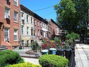
In 1846, surveyor Richard Butt planned gardens in front of the brownstone houses in the oldest section of the neighborhood when he developed it. The homes are set further back from the street than is common in Brooklyn, and the large gardens became an iconic depiction of the neighborhood. The same year, a law was passed requiring that all buildings between Henry Street and Smith Street have 33 feet 5.25 inches (10.1918 m) between the building and the street for "courtyards". The large gardens can be seen from First to Fourth Place between Henry and Smith Streets, as well as on President, Carroll and Second Streets between Smith and Hoyt Streets.
Further development of the Carroll Gardens was aided by the draining in the late 1860s of the swampland which surrounded Gowanus Creek through the deepening and dredging of the Creek to create the Gowanus Canal. This provoked land speculation and a building boom throughout the area. It was during this period, from the late 1860s to the early 1880s, that the area which is now the Carroll Gardens Historic District began to be developed.
20th century
Italian immigrants began coming to the neighborhood in the late 19th century – dock workers and workers in the Brooklyn Navy Yard – continuing through the 1950s, which led to much of the Irish population of the area leaving beginning in the 1920s. The rise of the Italian population provoked questions about the role of the Mafia in the neighborhood. One theory has it that Carroll Gardens, which lies between a territory traditionally controlled by the Gambino crime family and one controlled by the Colombo family, is considered to be neutral territory, and has been, for the most part, left alone.
Carroll Gardens had long been considered to be part of either the larger area referred to as South Brooklyn, or the neighborhood known as Red Hook. That neighborhood had an informal division in the 1930s and 40s along Hamilton Avenue, with kids from south of the avenue, mostly of Italian descent, calling themselves "Hookers" or "Hookies" after Red Hook, and kids north of the street, mostly Irish, in what would now be Carroll Gardens called "Creekers" or "Creekies" after the now-drained Gowanus Creek. Violence between the two groups was common. The division between the neighborhoods became even stronger beginning in the late 1940s by the building of the Brooklyn-Queens Expressway and the Gowanus Expressway, which started the process of the Carroll Gardens area taking on a separate and distinct character of its own.
In the 1960s, young middle-class professionals began to be attracted to the Carroll Garden area due to its convenience to Manhattan, where many of them worked, and its growing reputation as a safe and quiet place to live. This began the gentrification of the neighborhood, and a response from older residents, who did not appreciate these "hippie" newcomers who had no ties to the community. Regardless, the neighborhood gradually received its own name at that time, and the Carroll Gardens Association was formed in 1964. One result was that the decades-long control of the area by a political machine was ended.
Today, Carroll Gardens is more middle class, while Red Hook, which had retained its working-class, waterfront ambiance, has only recently begun to feel the effects of gentrification. The ethnic divide between the two neighborhoods now has a racial character as well. As late as the 1990s, several highly publicized incidents of violence underscored the tension between African-Americans from Red Hook and the mostly Italian residents of Carroll Gardens.
21st century
Carroll Gardens has seen some French immigration since the late 1990s, and Bastille Day celebrations are held on July 14 of each year. International School of Brooklyn, a Nursery-8th grade independent school, offers a French and Spanish language immersion. One of the public schools in Carroll Gardens, the Carroll School, has one of the area's French dual-language programs.
Though still visible in local business and culture, the Italian segment of the community has decreased significantly from 52 percent of the population in 1980 to 22 percent in 2012. Still, despite the decline in the Italian segment of the population and the effects of gentrification, the neighborhood remains a strongly Italian one. Italians in the neighborhood often play Bocce games, speak several dialects of Italian, and operate many Italian restaurants and shops, as well as join fraternal and benevolent associations attached to specific towns in Italy. The Roman Catholicism of the Italian population is still evident in the many shrines, especially to the Virgin Mary, which can be seen in front gardens in the neighborhood, and the tradition of a procession celebrating Good Friday continues. Adult children who had moved away from Carroll Gardens have started returning to the neighborhood to raise their children.
Carroll Gardens Historic District
The development of what is now the Carroll Gardens Historic District began in the 1870s, due in part to its proximity to Carroll Park. The district was created by the New York City Landmarks Preservation Commission in 1973. It includes houses located in a rough rectangle bounded by Carroll, President, Smith, and Hoyt Streets, as well as the western ends of the two blocks between President Street and First Street. The district includes some of the finest examples of brownstones with large front gardens.
Points of interest
Education
The New York City Department of Education operates a number of public schools in the neighborhood: Patrick F. Daly (P.S. 15), John M. Harrigan (P.S. 29), Carroll School (P.S. 58), Samuel Mills Sprole (P.S. 32), the Brooklyn New School (P.S. 146), Brooklyn School of Collaborative Studies (M.S. 448), and the School for Innovation (M.S. 442).
Also in the area are the New Dawn Charter High School, International School of Brooklyn, Hannah Senesh Community Day School, the Mary McDowell Friends Middle School, and St. Mary's School.
The Brooklyn Public Library operates the Carroll Gardens Branch at 396 Clinton Street and Union Street in Carroll Gardens. The library, originally the Carroll Park Branch, opened in 1901 in a rented facility. The library moved to its current Carnegie library facility, designed by William B. Tubby, in 1905. After extensive renovations, the library received its current name in response to a request from the community.