
Country United States City New York City Elevation 15 m | State New York ZIP Codes 11215, 11217 Borough Brooklyn | |
 | ||
Hotels Baum + Whiteman, Viv's, Charlie Curwen (1B) Restaurants al di la Trattoria, Stone Park Cafe, Union Hall, Pork Slope, Bogota Latin Bistro | ||
Park slope most beautiful neighborhood in brooklyn
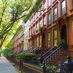
Park Slope is a neighborhood in northwest Brooklyn, New York City. Park Slope is roughly bounded by Prospect Park and Prospect Park West to the east, Fourth Avenue to the west, Flatbush Avenue to the north, and Prospect Expressway to the south. Generally, the section from Flatbush Avenue to Garfield Place (the "named streets") is considered the "North Slope", the section from 1st through 9th Streets is considered the "Center Slope", and south of 10th Street, the "South Slope". The neighborhood takes its name from its location on the western slope of neighboring Prospect Park. Fifth Avenue and Seventh Avenue are its primary commercial streets, while its east-west side streets are lined with brownstones and apartment buildings.
Contents
- Park slope most beautiful neighborhood in brooklyn
- Map of Park Slope Brooklyn NY USA
- A look at park slope brooklyn real estate block by block the new york times
- Development
- Baseball
- 1960 air collision
- Decline
- Gentrification
- Transportation
- Community institutions
- Religious institutions
- Public schools
- Private schools
- References
Map of Park Slope, Brooklyn, NY, USA
Park Slope features historic buildings, top-rated restaurants, bars, and shops, as well as proximity to Prospect Park, the Brooklyn Academy of Music, the Brooklyn Botanic Garden, the Brooklyn Museum, the Brooklyn Conservatory of Music, and the Central Library as well as the Park Slope branch of the Brooklyn Public Library system. The neighborhood had a population of about 62,200 as of the 2000 census, resulting in a population density of approximately 68,000/square mile, or approximately 26,000/square kilometer.
Park Slope is considered one of New York City's most desirable neighborhoods. In 2010, it was ranked number 1 in New York by New York Magazine, citing its quality public schools, dining, nightlife, shopping, access to public transit, green space, safety, and creative capital, among other aspects. It was named one of the "Greatest Neighborhoods in America" by the American Planning Association in 2007, "for its architectural and historical features and its diverse mix of residents and businesses, all of which are supported and preserved by its active and involved citizenry." In December 2006, Natural Home magazine named Park Slope one of America's ten best neighborhoods based on criteria including parks, green spaces and neighborhood gathering spaces; farmers' markets and community gardens; public transportation and locally owned businesses; and environmental and social policy. Park Slope is part of Brooklyn Community Board 6.
A look at park slope brooklyn real estate block by block the new york times
Development
The area that today comprises the neighborhood of Park Slope was first inhabited by the Native Americans of the Lenape people. The Dutch colonized the area by the 17th century and farmed the region for more than 200 years. During the American Revolutionary War, on August 27, 1776, the Park Slope area served as the backdrop for the beginning of the Battle of Long Island. In this battle, over 10,000 British soldiers and Hessian mercenaries routed outnumbered American forces. The historic site of Battle Pass is now preserved in Prospect Park, and on Fifth Avenue there is a reconstruction of the stone farmhouse where a countercharge covered the American retreat.
In the 1850s, a local lawyer and railroad developer named Edwin Clarke Litchfield (1815–1885) purchased large tracts of what was then farmland. Through the American Civil War era, he sold off much of his land to residential developers. During the 1860s, the City of Brooklyn purchased his estate and adjoining property to complete the West Drive and the southern portion of the Long Meadow in Prospect Park. However, Park Slope’s bucolic period ended soon after. By the late 1870s, with horse-drawn rail cars running to the park and the ferry, bringing many rich New Yorkers in the process, urban sprawl dramatically changed the neighborhood into a streetcar suburb. Many of the large Victorian mansions on Prospect Park West, known as the Gold Coast, were built in the 1880s and 1890s to take advantage of the beautiful park views. Today, many of these buildings are preserved within the 24-block Park Slope Historic District, one of New York's largest landmarked neighborhoods. By 1883, with the opening of the Brooklyn Bridge, Park Slope continued to boom and subsequent brick and brownstone structures pushed the neighborhood's borders farther. The 1890 census showed Park Slope to be the richest community in the United States.
In 1892, President Grover Cleveland presided over the unveiling of the Soldiers' and Sailors' Arch at Grand Army Plaza, a notable Park Slope landmark. The Park Slope Armory was completed in 1893. Nearby, Old Stone House is a 1930 reconstruction of the Vechte-Cortelyou House which was destroyed in 1897. It is located on Third Street between Fourth and Fifth Avenues, beside the former Gowanus Creek.
Realtors and community members saw a clear connection between Park Slope's bucolic setting and the comfort of living there. As the New York Tribune wrote in 1899, "Nature set the park down where it is, and man has embellished her work in laying out great lawns and artificial lakes, in bringing together menageries and creating conservatories, in making roads and driveways, and in doing everything in his power to make the place a pleasant pleasure ground and a charming resort."
Baseball
Baseball had also played a prominent role in the history of the Park Slope area. From 1879 to 1889, the Brooklyn Atlantics (later to become the Dodgers) played at Washington Park on 5th Avenue between 3rd and 4th Streets. When the park was destroyed by a fire, the team moved to their part-time home in Ridgewood, Queens and then to a park in East New York. In 1898, the "New" Washington Park was built between Third and Fourth Avenues and between First and Third Streets near the Gowanus Canal. The team, by this point known as the Dodgers, played to an ever-growing fan base at this location. By the end of the 1912 season, it was clear that the team had outgrown the field, and the neighborhood. Team owner Charles Ebbets moved the team to his Ebbets Field stadium in Flatbush for the beginning of the 1913 season. The team went on to have historic crosstown rivalries with both the New York Giants and New York Yankees.
1960 air collision
On December 16, 1960, two airliners collided above Staten Island, killing 134 people in what was the worst U.S. aviation disaster at that time. One of the airplanes, a Douglas DC-8 operated by United Airlines, was able to stay airborne for a few miles before crashing near the corner of Sterling Place and Seventh Avenue, destroying several buildings. Everyone on board was instantly killed, except for one 11-year-old boy, Stephen Baltz, who survived the night at nearby New York Methodist Hospital before succumbing to his injuries. Six people on the ground were also killed, including Wallace E. Lewis, the church's 90-year-old caretaker; Charles Cooper, a sanitation worker who was shoveling snow; Joseph Colacino and John Opperisano, who were selling Christmas trees on the sidewalk; Dr. Jacob L. Crooks, who was out walking his dog; and Albert Layer, the owner of a butcher shop located just off Seventh Avenue on Sterling Place.
Decline
By the 1950s, many of the wealthy and middle-class families fled for the suburban life and Park Slope became a rougher, more working-class neighborhood. It became mostly Italian and Irish in the 1950s and 1960s, though this changed by 1970s as the black and Latino population of the Slope increased and many of the Italian and Irish population began to relocate.
Some of those that did not relocate reacted violently to the ethnic changes to the neighborhood; for example, white residents of Park Slope attempted to bar African-Americans from participating in after-school programs at William Alexander Middle School in 1966. After this failed, white teenagers engaged in firebomb attacks on African-American homes on Fourth Street. In 1968, a street fight between Italian and African-American gangs occurred at Fifth Avenue and President Street, using bricks and bottles as weapons; in the aftermath of the fight, fourteen African-Americans and three Italian-Americans were arrested.
Gentrification
In the late 1960s and early 1970s, the renovation of a now-US$4.8 million brownstone along Berkeley Place sparked a trend where the rest of the brownstones were cleaned up, and the grittiness of the neighborhood was removed. Young professionals began to buy and renovate brownstones (which only cost around US$15,000–35,000 at the time), often converting them from rooming houses into single and two-family homes. Preservationists helped secure landmark status for many of the neighborhood's blocks of historic row houses, brownstone, and Queen Anne, Renaissance Revival, and Romanesque mansions. After the 1973 creation of the landmark district, primarily above 7th Avenue, the rate of gentrification was sped up, and throughout the 1970s, the area saw an influx of young professional couples.
By the early 1980s, however, even as the gentrification of the neighborhood was rapidly proceeding, crime was soaring, along with crime in the rest of New York City. In addition to a rumored crack house near Prospect Park, the neighborhood was affected by daily muggings and shootings.
Gentrification accelerated during the 1980s and 1990s as working-class families were generally replaced by upper-middle-class people being priced out of Manhattan or Brooklyn Heights. The Park Slope Historic District was listed on the National Register of Historic Places in 1980. The influx of these new upper middle class residents has made Park Slope one of the wealthiest neighborhoods in Brooklyn. Sociologist and urban theorist Sharon Zukin has written of the trend, "In Park Slope, the middle class found a sense of history and a picturesque quality that fit their sense of themselves." Since the mid-1990s young and childless professionals who in previous decades would most likely have lived in Manhattan have been moving to the neighborhood in ever-increasing numbers. Gentrification has also overflowed even into the surrounding areas, such as Prospect Heights to the north and Windsor Terrace to the southeast.
A 2001 report by the New York City Rent Guidelines Board found that from 1990 to 1999, rents in Park Slope increased by 3.5–4.4% per year, depending on what kind of building the apartment was in. Due to the rise in property values in Park Slope, the neighborhood experienced a boundary rebranding, in which real-estate agents coalesced Fort Greene into Bedford-Stuyvesant; South Slope, Prospect Heights, Windsor Terrace, Gowanus, Greenwood Heights, and Boerum Hill into part of greater Park Slope.
Transportation
The neighborhood is well-served by the New York City Subway. The IND Culver Line (F G trains) runs along Ninth Street, a main shopping street, stopping at Fourth Avenue, Seventh Avenue and 15th Street – Prospect Park/Prospect Park West. The IRT Eastern Parkway Line (2 3 4 5 trains) runs under Flatbush Avenue with an express stop at Atlantic Avenue – Barclays Center, and local stops (served by the 2 3 4 trains) at Bergen Street and Grand Army Plaza. The BMT Fourth Avenue Line's local trains (D N R trains) serve Prospect Avenue, Ninth Street, and Union Street stations, with the D N R trains all serving Atlantic Avenue – Barclays Center, an express station. The BMT Brighton Line (B Q trains) also passes through the neighborhood under Flatbush Avenue making stops at Atlantic Avenue – Barclays Center and Seventh Avenue. All three stations at Atlantic Avenue are connected to each other.
Additionally, several MTA New York City Transit bus routes serve the area, including the B61, B63, B67, and B69.
Community institutions
Religious institutions
Park Slope is home to a wide variety of religious institutions, or houses of worship, including many churches and synagogues; most are historic buildings, and date back many decades.
Churches include:
There is a significant Jewish population in Park Slope, allowing for a number of synagogues along the religious spectrum. In addition to a number of synagogues, there is an eruv, sponsored by members of the various communities, that surrounds Park Slope.
Synagogues include:
Public schools
Public schools are operated by the New York City Department of Education. Park Slope is in two different community school districts – district 13 and district 15. The border between these two districts is Union Street from Prospect Park West to Sixth Avenue and then President Street from Fourth to Sixth Avenue. North of this border is District 13, south of this border is district 15. Students are zoned to schools for elementary school Both district 13 and district 15 place students in middle school based on the student's ranking of acceptable middle schools; the district 13 portion of Park Slope receives district 15 (not district 13) middle school choice consistent with the rest of the neighborhood. The former John Jay High School is now the John Jay Educational Campus, housing three high schools and one combination middle/high school.