
Length 441 km | - elevation 2,880 ft (878 m) - elevation 2,900 ft (884 m) - elevation 1,158 ft (353 m) Basin area 9,780 km² | |
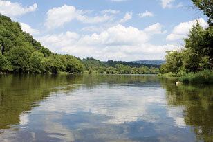 | ||
Trout fishing tennessee s holston river
The Holston River is a 136-mile (219,000 m) river that flows from Kingsport, Tennessee, to Knoxville, Tennessee. Along with its three major forks (North Fork, Middle Fork and South Fork), it comprises a major river system that drains much of northeastern Tennessee, southwestern Virginia, and northwestern North Carolina. The Holston's confluence with the French Broad River at Knoxville marks the beginning of the Tennessee River.
Contents
- Trout fishing tennessee s holston river
- Map of Holston River Tennessee USA
- South holston river brown trout fishing
- Power generationEdit
- AreaEdit
- NameEdit
- RecreationEdit
- Holston RiverEdit
- References
Map of Holston River, Tennessee, USA
The North Fork flows 138 miles (222 km) southwest from Sharon Springs in Bland County, Virginia. The Middle Fork flows 56.5 miles (90.9 km) from near the western border of Wythe County, Virginia, joining the South Fork in Washington County, Virginia, southeast of Abingdon. The South Fork rises near Sugar Grove in Smyth County and flows 112 miles (180 km) southwest to join the North Fork at Kingsport. The Watauga River, a tributary of the South Fork Holston, flows 78.5 miles (126,300 m) westward from Watauga County, North Carolina.
The main stem of the Holston is impounded by the Tennessee Valley Authority's Cherokee Dam near Jefferson City, Tennessee. Five other dams, also managed by TVA, impound the Holston's headwater streams: Watauga Dam and Wilbur Dam on the Watauga River, and Boone Dam, Fort Patrick Henry Dam, and South Holston Dam, on the South Fork Holston River.
South holston river brown trout fishing
Power generationEdit
The Holston River valley has been greatly developed for electrical power generation, both with hydroelectric dams and coal-fired steam plants. In the upper reaches, some of these plants are controlled by private interests; in the downstream portion, they are owned by the United States Government's Tennessee Valley Authority.
AreaEdit
Among the dams and associated reservoirs on the South Fork Holston River are Boone Dam and Boone Lake, named for the explorer Daniel Boone; Fort Patrick Henry Dam and Fort Patrick Henry Lake, named for the Revolutionary War hero; and South Holston Dam and South Holston Lake. Cherokee Dam on the Holston River forms Cherokee Lake, named for the historic Native Americans who occupied the areas along the Holston River at the time of European-American settlement. The United States settlers and army fought with the Cherokee over land and eventually removed most of them to territory west of the Mississippi River, under the 1830 Indian Removal Act.
NameEdit
Early Tennessee historian and Tennessee Supreme Court Justice John Haywood cited in his 1823 book The civil and political history of the state of Tennessee from its earliest settlement up to the year 1796, including the boundaries of the state that the Holston River was identified and named on earlier produced French maps as the "Cherokee River".
The Holston River was later named after Stephen Holstein, a European-American settler who built a cabin in 1746 on the upper reaches of the river. Holston Mountain was named after the Holston River.
RecreationEdit
All three forks in Virginia, South Holston Lake, and the Holston River in Tennessee below the South Holston Dam offer relatively easy-to-reach recreation opportunities. The North Fork in Virginia is known as an excellent smallmouth bass river (due to mercury contamination, fish caught in the North Fork of the Holston below Saltville, Virginia must not be consumed). Both the South Fork in Virginia and the first 20 miles (32 km) of the Holston in Tennessee below South Holston Dam are quality brown trout and rainbow trout fisheries. The Holston River is wide and open enough to allow extensive fly fishing. South Holston Lake offers a variety of fishing opportunity as well, as it contains smallmouth bass, common carp, walleye, pike, sunfish, crappie and a few trout.
Holston RiverEdit
The following is a list of major Road crossings on the Holston River: