
Website www.madisoncountyga.us Founded 5 December 1811 | Area 740.7 km² Population 28,057 (2013) Unemployment rate 5.4% (Apr 2015) | |
 | ||
Rivers Broad River, Hudson River, Mill Shoal Creek | ||
Madison County is a county located in the northeastern part of the U.S. state of Georgia. As of the 2010 census, the population was 28,120. The county seat is Danielsville. The county was created on December 5, 1811.
Contents
- Map of Madison County GA USA
- History
- Geography
- Adjacent counties
- 2000 census
- 2010 census
- Government
- Communities
- Notable residents
- Historic Sites
- References
Map of Madison County, GA, USA
Madison County was included in the Athens-Clarke County, GA Metropolitan Statistical Area, which is included in the Atlanta-Athens-Clarke County-Sandy Springs, GA Combined Statistical Area.
History
Named for James Madison, fourth president of United States, from 1809 to 1817, Madison County, was organized under act of General Assembly of Georgia, December 11, 1811. It was the 38th county formed in Georgia and began to operate as a county in 1812. Madison County formed from Oglethorpe, Clarke, Jackson, Franklin and Elbert counties.
Early agriculture in Madison County was devoted to food crops and livestock (cattle, hogs and sheep), which was sufficient to feed the population. Just after the Civil War ended, the demand for a cash crop led to a major reliance on cotton. The soils of Madison County were heavily damaged by this cotton monoculture. From the 1930s on, agriculture became more diverse. Today, agribusiness dominates the local economy, with poultry production particularly important.
Madison and Oglethorpe counties share Watson Mill Bridge State Park, the site of the longest covered bridge in Georgia. The bridge, which is over 100 years old, spans 229 feet of the South Fork of the Broad River. There are also facilities for camping, hiking trails, picnicking and fishing in the park.
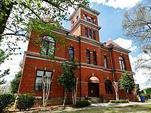
The Madison County Courthouse, one of the most ornate in Georgia, was built in 1901 for the sum of $18,314. It is listed on the National Register of Historic Places. New Hope Presbyterian Church, established in 1788, is the third oldest church in Georgia.
Lt. Col. Lemuel Penn, a decorated veteran of World War II and a United States Army Reserve officer, was murdered by members of the Ku Klux Klan on July 11, 1964, nine days after passage of the Civil Rights Act, on a Broad River bridge on the Georgia State Route 172 in Madison County.
Geography
According to the U.S. Census Bureau, the county has a total area of 286 square miles (740 km2), of which 282 square miles (730 km2) is land and 3.3 square miles (8.5 km2) (1.1%) is water.
The vast majority of Madison County is located in the Broad River sub-basin of the Savannah River basin, with just a very small portion of the county's western edge located in the Upper Oconee River sub-basin of the Altamaha River basin.
Adjacent counties
2000 census
As of the census of 2000, there were 25,730 people, 9,800 households, and 7,330 families residing in the county. The population density was 91 people per square mile (35/km²). There were 10,520 housing units at an average density of 37 per square mile (14/km²). The racial makeup of the county was 89.01% White, 8.46% Black or African American, 0.19% Native American, 0.28% Asian, 0.03% Pacific Islander, 1.03% from other races, and 0.99% from two or more races. 1.97% of the population were Hispanic or Latino of any race.
There were 9,800 households out of which 34.60% had children under the age of 18 living with them, 60.60% were married couples living together 10.60% had a female householder with no husband present, and 25.20% were non-families. 21.50% of all households were made up of individuals and 8.00% had someone living alone who was 65 years of age or older. The average household size was 2.61 and the average family size was 3.04.
In the county, the population was spread out with 26.30% under the age of 18, 8.20% from 18 to 24, 30.60% from 25 to 44, 23.90% from 45 to 64, and 11.00% who were 65 years of age or older. The median age was 36 years. For every 100 females there were 96.60 males. For every 100 females age 18 and over, there were 93.70 males.
The median income for a household in the county was $36,347, and the median income for a family was $42,189. Males had a median income of $31,324 versus $22,426 for females. The per capita income for the county was $16,998. About 9.20% of families and 11.60% of the population were below the poverty line, including 14.00% of those under age 18 and 16.50% of those age 65 or over.
2010 census
As of the 2010 United States Census, there were 28,120 people, 10,508 households, and 7,804 families residing in the county. The population density was 99.6 inhabitants per square mile (38.5/km2). There were 11,784 housing units at an average density of 41.7 per square mile (16.1/km2). The racial makeup of the county was 87.6% white, 8.4% black or African American, 0.6% Asian, 0.3% American Indian, 1.9% from other races, and 1.2% from two or more races. Those of Hispanic or Latino origin made up 4.1% of the population. In terms of ancestry, 20.7% were American, 9.1% were Irish, 9.1% were English, and 7.2% were German.
Of the 10,508 households, 35.4% had children under the age of 18 living with them, 56.9% were married couples living together, 12.1% had a female householder with no husband present, 25.7% were non-families, and 21.5% of all households were made up of individuals. The average household size was 2.66 and the average family size was 3.07. The median age was 39.4 years.
The median income for a household in the county was $41,343 and the median income for a family was $49,713. Males had a median income of $37,963 versus $28,732 for females. The per capita income for the county was $18,975. About 14.7% of families and 17.8% of the population were below the poverty line, including 22.7% of those under age 18 and 18.4% of those age 65 or over.
Government
The citizens of Madison County are represented by an elected six member board of commissioners. Each commissioner represents one of five districts plus a chairman of the board.
Board of Commissioners