
Founded 1868 Website www.oconeesc.com Population 75,045 (2013) Unemployment rate 5.7% (Apr 2015) | Area 1,746 km² | |
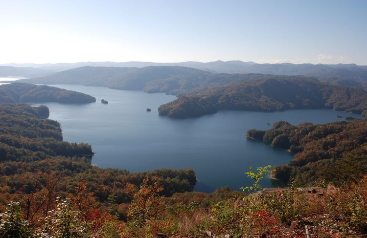 | ||
Points of interest Seneca Historic District, Lake Hartwell, Chau Ram County Park, Oconee Station and Richards, Stumphouse Mountain Tunnel Destinations | ||
Outdoor adventures in oconee county south carolina
Oconee County is the westernmost county in the U.S. state of South Carolina. As of the 2010 census, the population was 74,273. Its county seat is Walhalla.
Contents
- Outdoor adventures in oconee county south carolina
- Map of Oconee County SC USA
- History
- Geography
- National protected area
- 2000 census
- 2010 census
- Cities
- Towns
- Census designated places
- In popular culture
- References
Map of Oconee County, SC, USA
Oconee County is included in the Seneca, SC Micropolitan Statistical Area, which is also included in the Greenville-Spartanburg-Anderson, SC Combined Statistical Area.
South Carolina Highway 11, the Cherokee Foothills National Scenic Highway, begins in southern Oconee County at Interstate Highway 85 at the Georgia state line.
History
Oconee County takes its name from the Cherokee word "Ae-quo-nee" meaning "land beside the water." Oconee was a local Cherokee town that was situated on the main British/Cherokee trading path between Charleston and the Mississippi River in the early 18th century. Its geographic position later placed it at the intersection of the trading path and the Cherokee treaty boundary of 1777. In 1792, a frontier outpost was built by the SC State Militia near the town site and was named Oconee Station. When Oconee County was created out of the Pickens District in 1868 it was named for Oconee Town.
Geography
According to the U.S. Census Bureau, the county has a total area of 674 square miles (1,750 km2), of which 626 square miles (1,620 km2) is land and 47 square miles (120 km2) (7.0%) is water. The hilly landscape has created a haven for man-made lakes. Three large man-made lakes provide residents with sport fishing, water skiing, and sailing as well as hydroelectric power. The largest lake is Lake Hartwell, built by the U.S. Army Corps of Engineers between 1955 and 1963. Lake Keowee is the second largest lake and the Oconee Nuclear Station operates by the lake. Lake Jocassee is the third largest and is a source of hydroelectric energy, but is also popular for its breathtaking scenery and numerous waterfalls. Bad Creek Reservoir, located in the mountains above Jocassee, is for generating electricity during peak hours. The water level can fall by tens of feet per hour and during off-peak times water is pumped back into the lake for the next peak period. Because of this, boating and swimming are prohibited in the reservoir.
Oconee County is in the Savannah River basin.
National protected area
2000 census
As of the census of 2000, there were 66,215 people, 27,283 households, and 19,589 families residing in the county. The population density was 106 people per square mile (41/km²). There were 32,383 housing units at an average density of 52 per square mile (20/km²). The racial makeup of the county was 89.14% White, 8.38% Black or African American, 0.22% Native American, 0.35% Asian, 0.02% Pacific Islander, 1.06% from other races, and 0.82% from two or more races. 2.36% of the population were Hispanic or Latino of any race. 26.5% were of American, 13.1% Irish, 11.9% German and 10.5% English ancestry according to Census 2000.
There were 27,283 households out of which 28.50% had children under the age of 18 living with them, 57.80% were married couples living together, 10.10% had a female householder with no husband present, and 28.20% were non-families. 24.70% of all households were made up of individuals and 9.50% had someone living alone who was 65 years of age or older. The average household size was 2.40 and the average family size was 2.85.
In the county, the population was spread out with 22.90% under the age of 18, 8.00% from 18 to 24, 27.40% from 25 to 44, 26.20% from 45 to 64, and 15.60% who were 65 years of age or older. The median age was 40 years. For every 100 females there were 96.70 males. For every 100 females age 18 and over, there were 93.50 males.
The median income for a household in the county was $36,666, and the median income for a family was $43,047. Males had a median income of $31,032 versus $22,156 for females. The per capita income for the county was $18,965. About 7.60% of families and 10.80% of the population were below the poverty line, including 14.00% of those under age 18 and 12.90% of those age 65 or over.
2010 census
As of the 2010 United States Census, there were 74,273 people, 30,676 households, and 21,118 families residing in the county. The population density was 118.6 inhabitants per square mile (45.8/km2). There were 38,763 housing units at an average density of 61.9 per square mile (23.9/km2). The racial makeup of the county was 87.8% white, 7.6% black or African American, 0.6% Asian, 0.2% American Indian, 2.3% from other races, and 1.6% from two or more races. Those of Hispanic or Latino origin made up 4.5% of the population. In terms of ancestry,
Of the 30,676 households, 28.2% had children under the age of 18 living with them, 53.8% were married couples living together, 11.2% had a female householder with no husband present, 31.2% were non-families, and 26.2% of all households were made up of individuals. The average household size was 2.40 and the average family size was 2.86. The median age was 43.4 years.
The median income for a household in the county was $42,266 and the median income for a family was $52,332. Males had a median income of $40,943 versus $29,841 for females. The per capita income for the county was $24,055. About 11.8% of families and 16.6% of the population were below the poverty line, including 22.7% of those under age 18 and 9.4% of those age 65 or over.
Cities
Towns
Census-designated places
In popular culture
The Oconee region is mentioned in the song "Yankee Bayonet (I Will Be Home Then)" by the indie rock group the Decemberists, on their 2006 album The Crane Wife. The reference is "When I was a girl how the hills of Oconee made a seam to hem me in."