
Length 116 km | Country United States of America | |
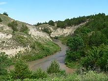 | ||
Dismal river ne fall 2013
The Dismal River is a winding 71.9-mile-long (115.7 km) river in the state of Nebraska. It is formed by the confluence of two forks, one of which has its origins in Grant County and the other in Hooker County. The forks meet near Nebraska Highway 97 between Mullen and Tryon. From here the Dismal River flows east-southeast into Thomas County, crossing U.S. Highway 83 south of Thedford. Passing just south of the Nebraska National Forest (once the Dismal River National Forest), it turns slightly to the northeast before its confluence with the Middle Loup River just west of Dunning in Blaine County.
Contents
Map of Dismal River, Nebraska, USA
Most of the land along the river is privately owned and used for ranching. The water comes from the Ogalalla Aquifer and boils up beneath the river in places, sometimes creating areas of quicksand. Deer, coyotes, beavers, turkey and rattlesnakes inhabit the area along the river.
Though much of the river's length is unpopulated, the Dismal River Golf Course, designed by Jack Nicklaus, borders it south of Mullen.