
- elevation 1,424 ft (434 m) Basin area 38,850 km² | Length 109 km Basin area 38,850 km² | |
 | ||
Sources North Loup River, Middle Loup River | ||
The Loup River (pronounced /lup/) is a tributary of the Platte River, approximately 68 miles (109 km) long, in central Nebraska in the United States. The river drains a sparsely populated rural agricultural area on the eastern edge of the Great Plains southeast of the Sandhills. The name of the river means "wolf" in French, named by early French trappers after the Skidi band of the Pawnee, whose name means "Wolf People," and who lived along its banks. The river and its tributaries, including the North Loup, Middle Loup, and South Loup, are known colloquially as "the Loups", comprising over 1800 mi (2900 km) of streams and draining approximately one-fifth of Nebraska.
Contents
Map of North Loup River, Nebraska, USA
CourseEdit
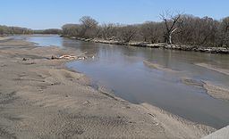
The river is formed in eastern Howard County, approximately 5 miles (8 km) northeast of St. Paul and 20 miles (32 km) north of Grand Island, by the confluence of the North Loup and Middle Loup rivers. It flows east-northeast, past Fullerton, where it is joined from the north by the Cedar River. It continues east-northeast roughly parallel to the Platte, past Genoa, separated from the Platte by approximately 15 mi (24 km). It joins the Platte from the northwest approximately 4 miles (6 km) southeast of Columbus.
A diversion dam southwest of Genoa diverts water to the Loup Canal to hydroelectric facilities in Monroe and then in Columbus. The canal then runs into the Platte a short distance below its confluence with the Loup.
The North Loup River is spanned by the Twin Bridge, listed on the National Register of Historic Places, near Brownlee.