
 | ||
The Delaware & Lehigh Canal National and State Heritage Corridor is a 165-mile (266 km) National Heritage Area in eastern Pennsylvania in the United States. It stretches from north to south, across five counties and over one hundred municipalities. It follows the historic routes of the Lehigh and Susquehanna Railroad, Lehigh Valley Railroad, the Lehigh Navigation, Lehigh Canal, and the Delaware Canal, from Bristol (northeast of Philadelphia) to Wilkes-Barre in the northeastern part of the state. The backbone of the Corridor is the 165-mile (266 km) D & L Trail. The Corridor's mission is to preserve heritage and conserve green space for public use in Bucks, Northampton, Lehigh, Carbon, and Luzerne counties in Pennsylvania.
Contents
- Delaware and lehigh national heritage corridor earth day clean up small
- Geography
- Activities
- DL Trail
- Recreation
- Historical appreciation
- Pre European trading routes
- 18th 20th centuries Coal mining era
- A National Heritage Area
- DL Trail takes shape
- References
Delaware and lehigh national heritage corridor earth day clean up small
Geography
The Corridor is a contiguous, five-county region in eastern Pennsylvania. It contains the counties of Luzerne, Lehigh, Carbon, Bucks, and Northampton. Major rivers include the Susquehanna, Delaware, and Lehigh.
Activities
The mission of the Delaware and Lehigh National Heritage Corridor is to enrich communities through actions and partnerships that conserve the resources, preserve the history, and enhance the quality of life. Today, the Corridor offers a broad range of experiences for visitors and residents such as hiking, boating, camping, biking, and fishing.
Historically, the Corridor has been used to link people and communities, and this is still a prominent goal of the Corridor today. The entire trail is used to connect and promote the importance of this region. Each community has unique ecological attributes and a diversified history to conserve. The Corridor preserves these features and offers an opportunity to educate and enjoy nature.
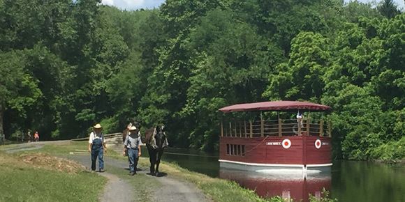
D&L Trail
The D&L Trail is a 165-mile (266 km) multi-use trail. The trail incorporates rail trails, rails with trails, share-the-road sections, and canal towpaths.
The trail follows the route that anthracite coal took from mine to market. It winds through northern mountains and along the banks of the Lehigh and Delaware Rivers through northeast Pennsylvania, the Lehigh Valley, and Bucks County. The D&L Trail passes through towns, industrial powerhouses, and along remnants of the Lehigh and Delaware canals. This earthen path exposes walkers, hikers, bicyclists, and others to Pennsylvania wildflowers, waterfalls, and wildlife.
Currently, 135 miles (217 km) of the trail are completed. The southern terminus of the trail is in Bristol, Bucks County. The northern terminus of the trail is in Mountain Top, Luzerne County. Work has begun on extending the trail from Mountain Top—to—Wilkes Barre at Seven Tubs Natural Area. From Mountain Top to White Haven, the trail is locally known as the Black Diamond Trail. From White Haven to Jim Thorpe, the trail is locally known as the Lehigh Gorge Trail, a 26-mile (42 km) section that parallels the Lehigh River and the valley of the Lehigh Gorge at Lehigh Gorge State Park. From Easton to Bristol, the trail is known as the Delaware Canal towpath, a 60-mile (97 km) section that passes entirely through Delaware Canal State Park. The Delaware Canal towpath is a National Recreation Trail.
The highest point on the trail is 1,785 ft (544 m) in Mountain Top; the lowest point is 20 ft (6.1 m) in Bristol.
Recreation
The Corridor contains more than 100,000 acres (40,000 ha) of public lands for outdoor recreation, including many state, county, and local parks.
Historical appreciation
The Corridor includes hundreds of historical sites related to a variety of subjects including: social development of young America (Leni Lenape settlements, the anthracite coal mining era (the Molly Maguires labor movement), the Industrial Revolution (Bethlehem Steel), the development of systematic canals (the Lehigh Navigation, Lehigh and Delaware Canals), the development of rail transportation (Lehigh Valley Railroad), and the evolution of natural conservation (John J. Audubon and Bucks County conservation movement).
It also features sites that can be interpreted to represent the transforming principles that became the foundation of the American Constitution — religious freedom, mutual responsibility between government and the people, and equality.
Pre-European trading routes
The Corridor has long been a busy crossroads. Native Americantribes such as the Susquehannock, Iroquois, Leni Lenape, and others frequently traveled through the northern region. The Delaware Canal parallels old trading routes. Many original Native American villages that developed here in the wilds of Pennsylvania drew European settlers in search of opportunity.
18th - 20th centuries: Coal mining era
In 1791, Philip Grinder found anthracite coal in what is now Summit Hill, Carbon County, PA. Coal helped the region develop and contributed to America’s iron and steel industries. The anthracite coal in the region is known as "stone coal" because of its rock-like hardness. Anthracite is created over millions of years as countless layers of sediment compress plant debris from swamps until it becomes hard. The Delaware and Lehigh National Heritage Corridor follows the route stone coal took from mine to market, winding through northern mountains and along the banks of the Lehigh and Delaware Rivers.
In the early to mid-1800s, a lengthy network of locks, canals, and towpaths was built to ship anthracite, further aiding the mining industry’s growth. The Lehigh Canal system generated a great deal of industrial development in the form of mining and the accompanying infrastructure. It gave rise to many towns and offshoot businesses, such as timber cutting, sawmills, steel mills, tanneries, etc. The Delaware Canal, on the other hand, was a means of shipping goods and establishing commerce. It supplemented existing overland routes resulting in the lack of an industrial boom along this route. However, the Lehigh and Delaware Canals merged to create part of a grand transportation systems stretching from the Appalachian Mountains to the Atlantic Ocean. In 1862 a massive flood, which destroyed dams, locks, canal boats, and villages, helped to shift the shipping of anthracite coal towards the railroads.
Much like the canals, railroads helped to transport goods and contribute to the development of the region. Asa Packer's Lehigh Valley Railroad, which ran from Mauch Chunk to Easton and on to New York City, was the first rail line to have a significant impact. The Lehigh & Susquehanna Railroad, Reading Railroad, and the Pennsylvania Railroad also moved into the area to create competition for the shipping of coal and goods. The canals and railroads that serve as the Corridor’s backbone once transported coal, lumber, slate, iron, cement, and steel from mountain to market, fueling the Industrial Revolution and supplying downstream industries for more than a century. Of all the products and businesses born out of the coal and transportation connection, none were as significant as Bethlehem Steel, locally known as "The Steel."
A National Heritage Area
In 1988, U.S. Congress designated the Corridor as nationally significant, in recognition of its nine National Historic Landmarks, six National Recreation Trails, two National Natural Landmarks and hundreds of sites listed in the National Register of Historic Places. A National Heritage Area is a region that has been recognized by the United States Congress for its unique qualities and resources. It is a place where a combination of natural, cultural, historic, and recreational resources have shaped a cohesive, nationally distinctive landscape.
Heritage areas allow local communities to cooperate on efforts to preserve the resources that are important to them. This partnership approach to heritage development allows collaboration around a theme, industry, and/or geographical feature that influenced the region’s culture and history. This strategy encourages individuals and agencies to prioritized programs and projects that recognize, preserve, and celebrate many of America’s defining landscapes.
D&L Trail takes shape
In 2013, work was completed on 10 miles of trail from White Haven to Mountain Top. This section of the trail is locally known as the Black Diamond Trail. This is the first trail section that leaves the Lehigh River; it replaces abandoned rail beds. A trailhead and parking lot near Mountain Top were also completed. The trailhead is located on land owned by the PA DCNR Bureau of Foresty and the PA Game Commission. Funding was made possible by a $1.2m grant from the Federal Highway Administration through PennDOT.
Gaps in the trail were also filled. A gap was filled at the crossing of State Route 13 in Levittown. Another gap was filled between Riverview Park in Palmer Township and Hugh Moore Park in Easton.