
- elevation 1,180 ft (360 m) Length 747 km Sources Cooperstown, Otsego Lake | - elevation 1,980 ft (604 m) Discharge 1,135 m³/s Cities Harrisburg, Binghamton | |
 | ||
- left Lackawanna River, Mahanoy Creek, Swatara Creek, Conestoga River - location Cooperstown, Otsego County, New York, USA - location Carrolltown, Cambria County, Pennsylvania, USA - location Cecil County / Harford County, at Havre de Grace, Maryland, USA Mouths Havre de Grace, Chesapeake Bay Bridges Rockville Bridge, Columbia–Wrightsville Bridge Similar Conowingo Dam, Rockville Bridge, Columbia–Wrightsville Bridge, Schuylkill River, Allegheny Mountains | ||
Mapping the historic susquehanna river
The Susquehanna River (/ˌsʌskwəˈhænə/; Lenape: Siskëwahane) is a major river located in the northeastern United States. At 464 miles (747 km) long, it is the longest river on the American east coast that drains into the Atlantic Ocean. With its watershed, it is the 16th-largest river in the United States, and the longest river in the continental United States without commercial boat traffic today. In the Canal Era, navigation improvements were made to enhance the river for barge shipping of bulk goods by water transport on the Pennsylvania Canal; competition from faster transport via the railroad industry resulted in reducing the maintenance on the river.
Contents
- Mapping the historic susquehanna river
- Map of Susquehanna River United States
- Susquehanna river bridge havre de grace maryland
- GeologyEdit
- CourseEdit
- North Branch SusquehannaEdit
- West Branch SusquehannaEdit
- Main Susquehanna flowEdit
- EtymologyEdit
- HistoryEdit
- Bridges ferries canals and damsEdit
- Environmental threatsEdit
- RecreationEdit
- References
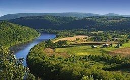
Map of Susquehanna River, United States
The Susquehanna rises and flows through New York, Pennsylvania, and Maryland into the Chesapeake Bay. It forms from two main branches: the "North Branch", which rises in upstate New York and is regarded by federal mapmakers as the main branch, and the West Branch Susquehanna. Both of these waterways were improved by navigations throughout the 1820s and 1830s as the Pennsylvania Canal. Together with facilities of the Allegheny Portage Railroad, loaded barges were transferred from the canal and hoisted across the mountain ridge into the Pittsburgh area. The 82-mile Union Canal was completed in 1828 to connect Schuylkill River in Reading to the Susquehanna above Harrisburg. An 82-mile leg connecting the Susquehanna with the Delaware River was instead developed as the Philadelphia and Columbia Railroad, built by the Pennsylvania Canal Commission. The shorter West Branch, which rises in western Pennsylvania, joins the main stem of the Susquehanna near Northumberland in central Pennsylvania.
The river drains 27,500 square miles (71,000 km2), including nearly half of the land area of Pennsylvania. The drainage basin (watershed) includes portions of the Allegheny Plateau region of the Appalachian Mountains, cutting through a succession of water gaps in a broad zigzag course to flow across the rural heartland of southeastern Pennsylvania and northeastern Maryland in the lateral near-parallel array of mountain ridges. The river empties into the northern end of the Chesapeake Bay at Havre de Grace, Maryland, providing half of the Bay's freshwater inflow. The Chesapeake Bay is the ria of the Susquehanna.
Susquehanna river bridge havre de grace maryland
GeologyEdit
The Susquehanna River is one of the oldest existing rivers in the world being dated as 320-340 Mya, older than the mountain ridges which it dissects, most of which resulted from the Alleghenian orogeny uplift events, when Africa (as part of Gondwana) slammed into the North American east (then part of EurAmerica). The Susquehanna basin reaches its ultimate outflow in the Chesapeake Bay, and like those for the Hudson, Delaware and Potomac rivers, was well established in the flat plains of eastern North America during the Mesozoic era about 252 to 66 million years ago.
CourseEdit
Both branches and the lower Susquehanna host transportation corridors, and the river was extensively used for muscle powered ferrys, boats, and canal boat shipping of bulk goods in the brief decades before the Pennsylvania Canal System was eclipsed by the coming of age of Steam powered railways. While less prevalent since their contraction in the 1950–1960s, the rivers shores still support a wide ranging rail transportation infrastructure.
North Branch SusquehannaEdit
Also called the Main Branch Susquehanna, the longer branch of the river rises at the outlet of Otsego Lake in Cooperstown, New York. From there, the north branch of the river runs west-southwest through rural farmland and dairy country, receiving the Unadilla River at Sidney and the Chenango in downtown Binghamton. It dips south into Pennsylvania briefly to turn sharply north at Susquehanna Depot hooking back into New York. After meandering westwards, it turns south crossing the line again through the twin-towns of Waverly, NY–‹See Tfd›Sayre and their large right bank railyard, once briefly holding the largest building in the world.
A couple miles south, just across the New York state line, in Athens Township (just south of Waverly, New York) in northern Pennsylvania it receives the Chemung from the northwest. It makes a right-angle curve between Sayre and Towanda to cut through the Endless Mountains in the Allegheny Plateau of Pennsylvania. It receives the Lackawanna River southwest of Scranton and turns sharply to the southwest, flowing through the former anthracite industrial heartland in the mountain ridges of northeastern Pennsylvania, past Pittston City (Greater Pittston), Wilkes-Barre, Nanticoke, Shickshinny, Berwick, Bloomsburg, and Danville.
West Branch SusquehannaEdit
The origin of the official West Branch is near Northern Cambria County, Pennsylvania near the junction of Mitchel Road and US Route 219 (locally Plank Road). It travels northeasterly through Curwensville (where the river is dammed to form a lake), into and through Clearfield, Pennsylvania, where it's joined by the Clearfield Creek right bank tributary.
The Clearfield Creek tributary rises in a Loretto, PA woodlands source spring outflow initially running northerly whilst draining the north-face and eastern slopes of the drainage divide crossing athwart the greater pass — the irregular rolling terrain of the several local gaps of the Allegheny—several of which end in the hilly pass around ‹See Tfd›Gallitzin Borough, & ‹See Tfd›Gallitzin Township, ‹See Tfd›Tunnelhill, ‹See Tfd›Cresson area — all above and within the greater Altoona, Pennsylvania area.
Clearfield Creek then passes through Cresson Lake and bends to flow generally northeast or north-northeast, passing through other tarns and gradually receiving tributary waters itself along its meanders gradually descend. Outside the pass flats, it becomes paralleled most of the time by PA Route 53 exploiting its valley through small towns like Ashville, PA, Glen Hope, PA and others serving witness to the gentle nature of its descent; still making its way north and east to the confluence in Clearfield—this valley is also exploited as a railroad corridor from Clearfield climbing to end in a wye within Cresson, PA in the same broad saddle pass as did the upper works of the Allegheny Portage Railroad and joining the railroad mainline climbing a nearby incline through the famous Horseshoe Curve (created by another Susquehanna River (main branch) tributary, in this case one feeding the waters (and railroads) of the Juniata River). The West Branch turns to the southeast and passes through Lock Haven and Williamsport before turning south. The North Branch joins the West Branch from the northwest at Northumberland, just above Sunbury.
Main Susquehanna flowEdit
Downstream from the confluence of its branches in Northumberland, the river flows south past Selinsgrove, where it is joined by its Penns Creek tributary, and cuts through a water gap at the western end of Mahantongo Mountain. It receives the Juniata River from the northwest at Duncannon, then passes through its last water gap, the Susquehanna Gap through the Blue Mountain Ridge, just northwest of Harrisburg.
Downtown Harrisburg developed on the east side of the river, which is nearly a mile wide here. Harrisburg is the largest city located on the lower river, which flows southeast across South Central Pennsylvania, forming the border between York and Lancaster counties, and receiving Swatara Creek from the northeast. It crosses into northern Maryland approximately 30 miles (48 km) northeast of Baltimore and is joined by Octoraro Creek. The river enters the northern end of the Chesapeake Bay at Havre de Grace. Concord Point Light was built here in 1827 to accommodate the increasing navigational traffic.
EtymologyEdit
"Susquehanna" comes from the Len'api (or Delaware Indian) term Sisa'we'hak'hanna, which means "Oyster River." This mighty river has two branches that come together at Sakima'ing (modern Sunbury, Northumberland County), and flows south past Harrisburg to Havre de Grace, Maryland, and into the Chesapeake Bay. Oyster beds were widespread in the bay, which the Lenape knew.
The Len'api referred to the people at Con'esto'ga ("Roof-place" or "town," modern Washington Boro, Lancaster County), also called Ka'ot'sch'ie'ra ("Place-crawfish," modern Chickisalunga, Lancaster County), or Gasch'guch'sa ("Great-fall-in-river," modern Conewago Falls, Lancaster County) as either Minquas ("quite different"), Mengwe ("without penis"), or Sisa'we'hak'hanna'lenno'wak ("Oyster-river-people"). The Len'api also called the area Sisa'we'hak'hanna'unk ("Oyster-river-place").
Along the Atlantic Coast, Native Americans were grouped among those coastal peoples who spoke the Algonquian languages, such as the Len'api (whose bands spoke three dialects of Lenape) and interior, Iroquoian languages-speaking peoples, such as the Eroni and the Five Nations of the Iroquois. The English of Pennsylvania referred to the Eroni (people) of Conestoga as "Susquehannocks" or "Susquehannock Indians," a name derived from the Lenape term. In addition, John Smith of Jamestown labeled their settlement as "Sasquesahanough" on his 1612 map when he explored the upper Chesapeake Bay area.
HistoryEdit
In the 1670s the Conestoga, or Susquehannock, succumbed to Iroquois conquest by the powerful Five Nations based in present-day New York, and assimilated with them. In the aftermath, the Iroquois resettled some of the semi-tributary Lenape in this area, as it was near the western boundary of the Lenape's former territory, known as Lenapehoking.
The river has played an important role throughout the history of the United States. In the 18th century, William Penn, the founder of the Pennsylvania Colony, negotiated with the Lenape to allow white settlement in the area between the Delaware River and the Susquehanna, which was part of Lenape territory. In late colonial times, the river became an increasingly important transportation corridor, used to ship anthracite coal discovered by Necho Allen in its upper reaches in the mountains.
In 1779 during the American Revolutionary War, General James Clinton led an expedition down the Susquehanna from its headwaters . His party had made the upper portion navigable by damming the river's source at Otsego Lake, allowing the lake's level to rise and then destroying the dam and flooding the river for miles downstream. This event is described by James Fenimore Cooper in the introduction to his novel, The Pioneers.
At Athens, Pennsylvania, then known as Tioga or "Tioga Point", Clinton met with General John Sullivan and his forces, who had marched from Easton, Pennsylvania. Together on August 29, they defeated the Tories and warriors of allied Iroquois bands at the Battle of Newtown (near present-day Elmira, New York). This was part of what was known as the "Sullivan-Clinton Campaign" or the "Sullivan Expedition". They swept through western New York, destroying more than 40 Iroquois villages, as well as their stores of crops set aside for winter. Many of the Iroquois went to Canada as refugees; casualties from exposure and starvation were high that winter.
Following the United States gaining independence in the Revolutionary War, in 1790 Colonel Timothy Matlack, Samuel Maclay and John Adlum were commissioned by the Supreme Executive Council of the Commonwealth of Pennsylvania to survey the headwaters of the river. They were to explore a route for a passage to connect the West Branch with the waters of the Allegheny River. In 1792, the Union Canal was proposed in order to link the Susquehanna and the Delaware rivers along Swatara and Tulpehocken creeks. In the 19th century, many industrial centers developed along the river, using its water power to drive mills and coal machinery, as well as to transport raw and manufactured goods.
Pennsylvania and Connecticut both claimed land from the colonial era in the Wyoming Valley along the Susquehanna. Connecticut founded Westmoreland County here and defended its claim in the Pennamite Wars. Under federal arbitration, eventually the state ceded this territory to Pennsylvania.
In the 1790s English Lake Poets Robert Southey, Samuel Taylor Coleridge, and Robert Lovell formulated the "Pantisocracy Plan" to marry three sisters and move to the banks of the Susquehanna River to start a socialist experiment; the marriages were made, but Southey moved to Lisbon, Portugal to visit an uncle and the plan was abandoned.
In 1833 John B. Jervis began a canal system to extend the Chenango River and connect the waters of the Susquehanna from Chenango Point to the Erie Canal, which ran through the Mohawk Valley of New York, ultimately connecting with Lake Erie through the Wood Canal. In October 1836, water from the Susquehanna was connected to the Erie Canal at Utica, New York. Water travel was popular during that era, and the Erie Canal dramatically expanded trade between communities around the Great Lakes and markets in New York and Pennsylvania. With the expansion of construction of railroad lines, canal-transport became unprofitable, as it could not compete in speed or flexibility. Boats had to climb a net height of 1,009 feet between basins, requiring the use of more than 100 water locks, which were too expensive to be maintained under the new competition.
The Susquehanna River figures in the history of the Latter Day Saint movement, which holds that Joseph Smith and Oliver Cowdery received the priesthood from heavenly beings at a site along the Susquehanna in Western New York and performed their first baptisms of Latter Day Saints in the river. Smith and Cowdery said that they were visited on May 15, 1829, by the resurrected John the Baptist and given the Aaronic priesthood. Following his visit, Smith and Cowdery baptized each other in the river. Later that year, they said they were also visited near the river by the apostles Peter, James and John. Both events took place in unspecified locations near the river's shore in either Susquehanna County, Pennsylvania, or Broome County, New York.
During the Civil War's 1863 Gettysburg Campaign, the commander of the Department of the Susquehanna, Union Major General Darius N. Couch, resolved that Robert E. Lee's Confederate Army of Northern Virginia would not cross the Susquehanna. He positioned militia units under Maj. Granville Haller to protect key bridges in Harrisburg and Wrightsville, as well as nearby fords. Confederate forces reached the river at several locations in Cumberland and York counties but were recalled on June 29 when Lee chose to concentrate his army to the west.
In 1972 the remnants of Hurricane Agnes stalled over the New York-Pennsylvania border, dropping as much as 20 inches (510 mm) of rain on the hilly lands. Much of that precipitation was received into the Susquehanna from its western tributaries, and the valley suffered disastrous flooding. Wilkes-Barre, Pennsylvania, was among the hardest-hit communities and the capital Harrisburg was flooded. The Chesapeake Bay received so much fresh water that it altered the ecosystem, killing much of the marine life that depended on saltwater.
The Mid-Atlantic Flood of June 2006, caused by a stalled jet stream-driven storm system affected portions of the river system. The worst affected area was Binghamton, New York, where record-setting flood levels forced the evacuation of thousands of residents.
In September 2011 the Susquehanna River and its communities were hit by Tropical Storm Lee, which caused the worst flooding since Agnes in 1972.
Bridges, ferries, canals and damsEdit
The Susquehanna River has played an important role in the transportation history of the United States. Prior to the 1818 opening of the Port Deposit Bridge, the river formed a barrier between the northern and southern states, as it could be crossed only by ferry. The earliest dams were constructed to support ferry operations in low water. The presence of many rapids in the river meant that while commercial traffic could navigate down the river in the high waters of the spring thaws, nothing could move up. Two different canal systems were constructed on the lower Susquehanna to bypass the rapids. The first was the Susquehanna Canal, also called the Conowingo Canal or the Port Deposit Canal, completed in 1802 by a Maryland company known as the Proprietors of the Susquehanna Canal. The second was the much longer and more successful Susquehanna and Tidewater Canal. The canals required additional dams to provide canal water and navigation pools.
As the industrial age progressed, bridges replaced ferries, and railroads replaced canals. The railroads were often constructed on top of the canal right-of-way along the river. Many canal remnants can be seen in Havre de Grace, Maryland, along US Route 15 in Pennsylvania, and in upstate New York at various locations. These latter remnants are parts of the upstream divisions of the Pennsylvania Canal, of privately funded canals, and of canals in the New York system.
Today 200 bridges cross the Susquehanna. Two seasonal ferries continue to operate across the Susquehanna. The Millersburg Ferry at Millersburg, Pennsylvania is a practical ferry for up to four vehicles and 50 passengers, while the Pride of the Susquehanna at Harrisburg, Pennsylvania provides a passenger-only pleasure cruise. Most of the canals have been filled in or are partially preserved as a part of historical parks. Dams generally are used to generate power or to provide lakes for recreation. The Rockville Bridge, which crosses the river from Harrisburg to Marysville, Pennsylvania, was the longest stone masonry arch bridge in the world when it was constructed. It was built by the Pennsylvania Railroad in 1902, replacing an earlier iron bridge.
Environmental threatsEdit
The environmental group American Rivers named the Susquehanna "America's Most Endangered River for 2005" because of the excessive pollution it receives. Most of the pollution in the river is caused by excess animal manure from farming, agricultural runoff, urban and suburban stormwater runoff, and raw or inadequately treated sewage. In 2003 the river contributed 44% of the nitrogen, 21% of the phosphorus, and 21% of the sediment flowing into the Chesapeake Bay. It was designated as one of the American Heritage Rivers in 1997. The designation provides for technical assistance from federal agencies to state and local governments working in the Susquehanna watershed.
Another environmental concern is radioactivity released during the 1979 Three Mile Island accident.
In 2015, a smallmouth bass caught with a cancerous tumor from the river raised concerns about water pollution. The Environmental Protection Agency reported, however, "we do not have sufficient data at this time to scientifically support listing the main stem of the Susquehanna as impaired."
RecreationEdit
The Susquehanna River has long been associated with boating because of its many migratory fish. Many tourists and local residents use the Susquehanna in the summer for recreation purposes such as kayaking, canoeing, and motor-boating. Canoe races are held annually on various sections of the river, such as the amateur race held in Oneonta, New York.
Susquehanna rowing and paddling have a long history. Starting in 1874, rowers from Shamokin Dam, Pennsylvania raced men from Sunbury. The General Clinton Canoe Regatta, a 70-mile flat-water race, takes place each year in Bainbridge, New York on Memorial Day weekend. Binghamton University Crew and Hiawatha Island Boat Club are also located on the river, in the Southern Tier of New York.