
Traversed by D 926 Elevation 2,067 m | Road D926 | |
 | ||
Similar | ||
Col de la croix de fer verney cycling inspiration education
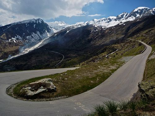
Col de la Croix de Fer (English: Pass of the Iron Cross) (el. 2067 m.) is a high mountain pass in the French Alps linking Le Bourg-d'Oisans and Saint-Jean-de-Maurienne.
Contents
- Col de la croix de fer verney cycling inspiration education
- Map of Col de la Croix de Fer 73530 Saint Sorlin dArves France
- Col du glandon col de la croix de fer
- Details of climb
- Tour de France
- References
Map of Col de la Croix de Fer, 73530 Saint-Sorlin-d'Arves, France
Col du glandon col de la croix de fer
Details of climb
The approach from the northeast from Saint-Jean-de-Maurienne is 29.5 km at an average gradient of 5.5% with some sections at 9.5%, and the one from the southwest from Rochetaillée 31.5 km at an average gradient of 5.75% with short sections in excess of 11%. When coming from Rochetaillée, the road forks 2.5 km before the summit, leading to the Col du Glandon. There is also an approach from the north from La Chambre via Col du Glandon which is the hardest: 22.7 km at an average gradient of 7.0% (this is the route used for the 2012 Tour de France).
Tour de France
The pass has featured in the Tour de France sixteen times since it was first passed in the 1947 tour when the race was led over the summit by Fermo Camellini. It was crossed on Stage 11 of the 2012 race, between Albertville and La Toussuire-Les Sybelles. In the 2015 race it was passed twice in the two finale mountain stages stage 19 between Saint-Jean-de-Maurienne to La Toussuire - Les Sybelles, and from the other side in stage 20 between Modane to Alpe d'Huez. The route for stage 20 was changed in June 2015 caused by a landslide in April so Col de la Croix de Fer substitutes both Col du Télégraphe and Col du Galibier.