
Traversed by D902B Range Alps | Elevation 2,645 m | |
 | ||
Similar Col du Lautaret, Col du Télégraphe, Alps, Col d'Izoard, Col de la Croix de Fer | ||
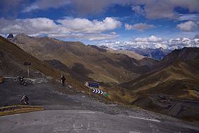
Col du Galibier (el. 2,645 metres (8,678 ft)) is a mountain pass in the southern region of the French Dauphiné Alps near Grenoble. It is the ninth highest paved road in the Alps and the sixth highest mountain pass. It is often the highest point of the Tour de France.
Contents
- Map of Col du Galibier 05220 Le MonC3AAtier les Bains France
- History
- Construction and opening of crest tunnel 18901891
- Details of the climb
- The Tour de France
- The Giro dItalia
- References
Map of Col du Galibier, 05220 Le Mon%C3%AAtier-les-Bains, France
It connects Saint-Michel-de-Maurienne and Briançon via the col du Télégraphe and the Col du Lautaret. The pass is closed during the winter. It is located between the massif d'Arvan-Villards and the massif des Cerces, taking its name from the secondary chain of mountains known as the Galibier.
Before 1976, the tunnel was the only point of passage at the top, at an altitude of 2556 m. The tunnel was closed for restoration until 2002, and a new road was constructed over the summit. The re-opened tunnel is a single lane controlled by traffic lights, which are among the highest such installations in Europe.
History
In 1876 first passable road could be opened between Maurienne and Briançonnais respectively Oisans. In the north passroad begins in Valloire, this place is only reachable via Col du Télégraphe which is before Galibier and connects Saint-Michel-de-Maurienne with Valloire. In the south the road beginns at a level of 2,057 m Col du Lautaret, which connects Grenoble in the west with Briançon in the east. Highest point of this road was at an altitude of 2,658 m, 16 meters higher than nowadays. Road between Col du Lautaret is 24,5 kilometers long, 16 kilometers is the northern part, 8,5 kilometers is the south part. Road over Galibier was first a natural road and later asphalted.
Construction and opening of crest tunnel 1890/1891
In the area of the summit it was hard to travel. This was the reason why in 1890 a crest tunnel (363 meters) was built, which was opened in 1891. The tube is four meters broad, a single track which can be passed only alternately. The new tunnel is at an altitude of 2556 meters, this is the reason why the highest ponit is now 102 meters lower. New build tunnel shortens the distance to 23 kilometers. 15 kilometers is the north part, 7,5 Kilometer is the south part and 0,5 kilometers is the crest tunnel.
Details of the climb
From the north, starting at Saint-Michel-de-Maurienne (including the Col du Télégraphe), the climb is 34.8 kilometres (21.6 mi) long, gaining 2,120 metres (6,960 ft) in height (an average of 6.1%). The actual climb to the summit starts at Valloire and is 18.1 kilometres (11.2 mi) long at an average of 6.9% (height gain: 1,245 metres (4,085 ft)). The maximum gradient is 10.1% at the summit.
From the south, the climb starts from the Col du Lautaret (el. 2,058 metres (6,752 ft)) and is 8.5 kilometres (5.3 mi) long at an average gradient of 6.9% (height gain: 585 metres (1,919 ft)) with a maximum of 12.1% at the summit.
On both sides of the Col du Galibier mountain pass cycling milestone are placed every kilometre (As of July 2015, some are missing in the final part of the climb from the Col du Lautaret). They indicate the distance to the summit, the current height, and the average slope in the following kilometre. Such signposting for cyclists has become common in most major mountain passes in the French Pyrenees and Alps.
The Tour de France
The Col du Galibier was first used in the Tour de France in 1911; the first rider over the summit was Emile Georget, who, with Paul Duboc and Gustave Garrigou were the only riders not to walk.
The original summit was at 2556 m.; while the tunnel was closed from 1976 until 2002, the tour route went only over the pass closer to the mountain peak at 2645 m. In 2011, the Tour de France went through the tunnel for the first time during the 19th stage from Modane Valfréjus to L'Alpe d'Huez.
At the south portal of the tunnel, at the edge of the road, there is a monument to Henri Desgrange, instigator and first director of the Tour de France. The memorial was inaugurated when the tour passed on 19 July 1949. Whenever the tour crosses the Col du Galibier, a wreath is laid on the memorial. The "Souvenir Henri Desgrange" is awarded to the first rider across the summit of the highest mountain in each year's tour. In 2006, the prize of 5,000 euros was claimed on the Col du Galibier by Michael Rasmussen.
Since 1947, the Col de Galibier has been crossed 31 times by the Tour de France. It was scheduled to be used in 1996, but was left out at the last minute due to bad weather. As a result of snow on both the Col de l'Iseran and the Col du Galibier, the scheduled 190 km stage from Val-d'Isère to Sestriere in Italy was reduced to a 46 km sprint from Le-Monetier-les-Bains which was claimed by Bjarne Riis, resulting in him taking the yellow jersey which he retained to the finish in Paris.
In the 2008 Tour, the Col du Galibier had been crossed on 23 July in the 210 km stage 17 from Embrun to Alpe d'Huez.
The 2011 Tour climbed the Col du Galibier twice to celebrate the 100th anniversary of the first appearance of the pass in the Tour de France, including the first ever summit finish, won by Andy Schleck after a 60 km solo breakaway. This was the highest ever stage finish in the Tour de France. It was scheduled to be used again in stage 20 of the 2015 Tour, but was left out nine days before the race start due to landslides in the Chambon Tunnel, situated towards the bottom of the descent of the climb.
The Giro d'Italia
The 2013 Giro d'Italia climbed the Col du Galibier, although the stage had to be shortened by 4 km due to heavy snowfall.