
Easiest route Southwest face Prominence 821 m | Elevation 3,984 m First ascent 1877 | |
 | ||
Listing Alpine mountains above 3000 m Similar Barre des Écrins, Le Râteau, Ailefroide, Grandes Rousses, Mont Pelvoux | ||
La grave la meije only for the best
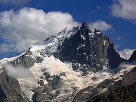
La Meije is a mountain in the Massif des Écrins range, located at the border of the Hautes-Alpes and Isère départements. It overlooks the nearby village of La Grave, a mountaineering centre and ski resort, well known for its off-piste and extreme skiing possibilities, and also dominates the view west of the Col du Lautaret. It is the second highest mountain of the Écrins after Barre des Écrins
Contents
- La grave la meije only for the best
- Map of Meije 05320 La Grave France
- La grave la meije skiing freeride powder goprohero4black
- Summits
- Historic ascents
- Approaches
- References
Map of Meije, 05320 La Grave, France
La grave la meije skiing freeride powder goprohero4black
Summits
Neighboring peaks are Le Râteau (3,809 m) to the west, past the Brèche de la Meije (3,357 m) and fr:Le Pavé (3,823 m) and Pic Gaspard (3,881 m) to the southeast, past the Brèche Maximin Gaspard (3,723 m)
Historic ascents
The central and second highest summit has five teeth, the highest of which is known as Doigt de Dieu (English: Finger of God). This summit was reached from the northeast on June 28, 1870, by Christian and Ulrich Almer and Christian Gertsch, guiding Meta Brevoort and W.A.B. Coolidge. The ridge from the central to the main, Western peak, which is 13 meters higher, was considered an insurmountable obstacle for the next 15 years.
The Western true summit of La Meije, the Grand Pic, is notorious in that there is no "easy" path to its top and it was the last major peak in the Alps to be summited. The first ascent was eventually made from the southwest on 16 August 1877 by father and son Pierre Gaspard and their client Emmanuel Boileau de Castelnau. Their approach, over the south buttress Arête du Promontoire and further over the Glacier Carré and the southwest face of the Grand Pic is now the normal route.
On July 26, 1885, Ludwig Purtscheller and the brothers Otto and Emil Zsigmondy made the first traverse from the central to the main summit, via the "insurmountable" gap that is now known as the Brèche Zsigmondy, in what is still considered a classic route though thoroughly modified by a may 1964 rockfall. The traverse in the opposite direction was accomplished 6 years later by Ulrich Almer, Fritz Boss and J.H. Gibson.
The south face is widely considered to be the most difficult of La Meije. Within two weeks after their successful traverse, the Zsigmondy brothers, together with Karl Schulz, tried to reach the Brèche Zsigmondy over the south face, but Emil died in the attempt. The first successful attempt was not until twenty-seven years later, in 1912 by Angelo Dibona, Luigi Rizzi, and the brothers Guido and Max Mayer, while a direct route over the south face to the Grand Pic was only climbed in 1935 and that to the Central Pic in 1951.
Approaches
For mountaineering, La Meije can be approached from two mountain refuges: