
 | ||
The Chinese–Russian border or the Sino–Russian border is the international border between China and Russia. After the final demarcation carried out in the early 2000s, it measures 4,209.3 km, and is the world's sixth-longest international border.
Contents
- Description
- The Czarist era pre 1917
- The Sino Soviet border 1917 1991
- Post 1991
- Border management
- Eastern section
- Western section
- References
The China–Russian border consists of two non-contiguous sections: the long eastern section and the much shorter western section.
Description
The eastern border section is over 4000 kilometres in length. According to a joint estimate published in 1999, it measured at 4,195 kilometres (2,607 mi). It starts at the eastern China–Mongolia–Russia tripoint (49°50′42.3″N 116°42′46.8″E), marked by the border monument called Tarbagan-Dakh (Ta'erbagan Dahu, Tarvagan Dakh). From the tripoint, the border line runs north-east, until it reaches the Argun River. The border follows the Argun and Amur river to the confluence of the latter with the Ussuri River. It divides the Bolshoy Ussuriysky Island at the confluence of the two rivers, and then runs south along the Ussuri. The border crosses Lake Khanka, and finally runs to the south-west. The China–Russia border ends when it reaches the Tumen River, which is the northern border of North Korea. The end point of the China–Russia border, and the China-Russia-North Korea tripoint, at (42°25′N 130°36′E), is located only a few kilometers before the river flows into the Pacific Ocean, the other end of the North Korea–Russia border.
The much shorter (less than 100 km) western border section is between Russia's Altai Republic and China's Xinjiang. It runs in the mostly snow-covered high elevation area of the Altai Mountains. Its western end point is the China–Kazakhstan–Russia tripoint, whose location is defined by the trilateral agreement as 49°06′54″N 87°17′12″E, elevation, 3327 m. Its eastern end is the western China–Mongolia–Russia tripoint, at the top of the peak Tavan Bogd Uul (Mt Kuitun), at the coordinates 49°10′13.5″N 87°48′56.3″E
The Czarist era (pre-1917)
Today's Sino-Russian border line is mostly inherited by Russia (with minor adjustments) from the Soviet Union, while the Sino-Soviet border line was essentially the same as the border between the Russian and Qing Empires, settled by a number of treaties in 17th through 19th century. Below is the list of important border treaties, along with the indication as to which sections today's Sino-Russian border were largely set by them:
The Sino-Soviet border (1917-1991)
Post-1917, territorial and political expansion of Russia, as well as China, have been the occasion for mutual territorial claims:
During 1968, the Soviet Army had amassed along the 4,380 km (2,738 mi.) border with China — especially at the Xinjiang frontier, in north-west China, where the Soviets might readily induce Turkic separatists to insurrection. Militarily, in 1961, the USSR had 12 divisions and 200 aeroplanes at that border; in 1968, there were 25 divisions, 1,200 aeroplanes, and 120 medium-range missiles. Moreover, even though PRC has more manpower available than the USSR, and it had already tested its first nuclear weapon (the 596 Test in October 1964, at Lop Nur basin), the People's Liberation Army was militarily inferior to the Soviet Army as far as equipment was concerned. Yet, the Chinese adopted a asymmetric deterrence strategy that threatened a large-scale conventional “People’s War” in response to a Soviet counterforce first-strike. China’s superiority in sheer numbers of troops was the cornerstone of Beijing’s strategy to deter a Soviet nuclear attack. Since 1949, Chinese military strategy as articulated by Chinese leader Mao Zedong continually emphasized the superiority of “man over weapons.” While weapons were certainly an important component of warfare, Mao argued that they were “not the decisive factor; it is people, not things, that are decisive. The contest of strength is not only a contest of military and economic power, but also a contest of human power and morale.” In Mao’s view, non-material qualities, including subjectivity, creativity, flexibility, and high morale, were critical determinants in warfare.” The Soviets were not confident they could win such a conflict. A large-scale Chinese incursion could threaten key strategic centers in Blagoveshchensk, Vladivostok, and Khabarovsk, as well as crucial nodes of the Trans-Siberian Railroad. According to Arkady Shevchenko, a high-ranking Russian defector to the United States, “The Politburo was terrified that the Chinese might make a large-scale intrusion into Soviet territory. A nightmare vision of invasion by millions of Chinese made the Soviet leaders almost frantic. Despite our overwhelming superiority in weaponry, it would not be easy for the U.S.S.R. to cope with an assault of this magnitude.” Given China’s “vast population and deep knowledge and experience in guerrilla warfare,” if the Soviets launched a major attack on China’s nuclear program they would surely become “mired in an endless war.” In fact, concerns about China’s strength in manpower and its “people’s war” strategy ran so deep that some bureaucrats in Moscow argued the only way to defend against a massive conventional onslaught was to use nuclear weapons. Some even advocated deploying nuclear mines along the Sino-Soviet border. By threatening to initiate a prolonged conventional conflict in retaliation for a nuclear strike, Beijing employed an asymmetric deterrence strategy intended to convince Moscow that the costs of an attack would outweigh the benefits. China had indeed found a potent threat. While most Soviet military specialists did not fear a Chinese nuclear reprisal, believing that China’s arsenal was so small, rudimentary, and vulnerable that it could not survive a first strike and carry out a retaliatory attack, there was great concern about China’s massive conventional army. Nikolai Ogarkov, a senior Soviet military officer, believed that a massive nuclear attack “would inevitably mean world war.” Even a limited counterforce strike on China’s nuclear facilities was dangerous, Ogarkov argued, because a few nuclear weapons would “hardly annihilate” a country the size of China, and in response China would “fight unrelentingly.”
While the PRC government never formally denounced the 19th century territory transfer agreements, it disagreed with the USSR on the exact interpretation of them, i.e. the exact course of the border line in some areas. On a few occasions, the Sino-Soviet border conflict involved open fighting, notably around the Damansky–Zhenbao Island in the Ussuri River in March 1969, and at Tielieketi (Terekty/Zhalanshkol, on the China–Kazakhstan border) in August 1969. In The Coming War Between Russia and China (1969), US journalist Harrison Salisbury reported that Soviet sources implied a possible first strike against the Lop Nur basin nuclear weapons testing site. The John F. Kennedy and Lyndon B. Johnson administrations had considered attempting to destroy the Chinese program before it succeeded, but the USSR had refused to cooperate. Now the U.S. warned the USSR that a nuclear attack against China would precipitate a worldwide war, and the USSR relented. Aware of that possibility, China built large-scale underground shelters, such as Beijing’s Underground City, and military shelters such as the Underground Project 131 command center, in Hubei, and the "816 Project" nuclear research center in Fuling, Chongqing.
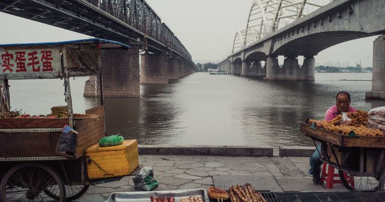
Heavily militarised following the Sino-Soviet split of the 1950s and 60s, culminating in the Sino-Soviet border conflict of 1969, the border slowly opened after 1982 allowing the first exchange of goods between the two countries. Between 1988 and 1992 the cross-border commerce between Russia and the Heilongjiang province increased threefold, with the number of legal Chinese workers in Russia increasing from 1286 to 18905.
Post-1991

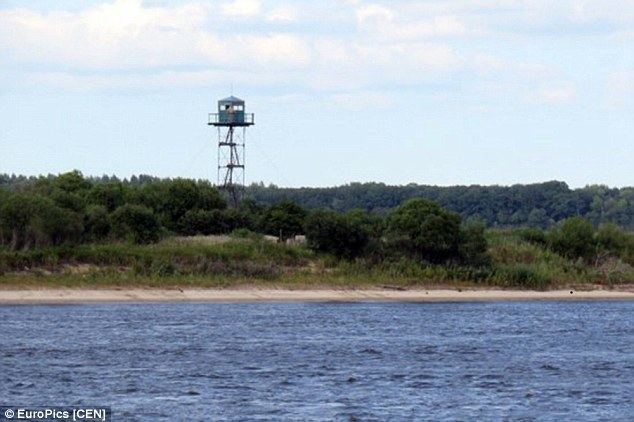
The waning years of the Soviet Union saw a reduction of the tensions on the then heavily fortified Sino-Soviet border. In 1990-91, the two countries agreed to significantly reduce their military forces stationed along the border. To this day one can find numerous abandoned military facilities in Russia's border districts.
Even though the Sino-Soviet border trade resumed as early as 1983-85, it accelerated in 1990-91; the rate of cross-border trade continue increasing as the USSR's former republics became separate states. To accommodate increasing volume of travel and private trade, a number of border crossings were re-opened. In early 1992, China announced border trade incentives and the creation of special economic zones along the Sino-Russian border. The largest of these was in Hunchun.
In 1991, China and USSR signed the 1991 Sino-Soviet Border Agreement, which intended to start the process of resolving the border disputes held in abeyance since the 1960s, and fully demarcating the Sino-Soviet border. However, just a few months later the USSR was dissolved, and four former Soviet republics — Russia, Kazakhstan, Kyrgyzstan, and Tajikistan — inherited various sections of the former Sino–Soviet border. Now it was up to them to continue the border regularization work.
It took more than a decade for Russia and China to fully resolve the border issues and to demarcate the border. On May 29, 1994, during Prime Minister Chernomyrdin's visit to Beijing, an "Agreement on the Sino-Russian Border Management System intended to facilitate border trade and hinder criminal activity" was signed. On September 3, a demarcation agreement was signed for the short (55 km) western section of the binational border; the demarcation of this section was completed in 1998.
In November 1997, at a meeting in Beijing, Russian President Boris Yeltsin and General Secretary and President Jiang Zemin signed an agreement for the demarcation of the much longer (over 4000 km) eastern section of the border, in accordance with the provisions of the 1991 Sino-Soviet agreement.
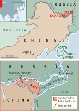
The last unresolved territorial issue between the two countries was settled by the 2004 Complementary Agreement between the People's Republic of China and the Russian Federation on the Eastern Section of the China–Russia Boundary Pursuant to that agreement, Russia transferred to China a part of Abagaitu Islet, the entire Yinlong (Tarabarov) Island, about a half of Bolshoy Ussuriysky Island, and some adjacent river islets. This resolved a border dispute between Russia and China, standing since Japanese invasion of Manchuria of 1931. These Amur River islands were until then administered by Russia and claimed by China. The event was meant to foster feelings of reconciliation and cooperation between the two countries by their leaders. The transfer has been ratified by both the Chinese National People's Congress and the Russian State Duma in 2005. The official transfer ceremony was held on-site October 14, 2008.
According to Russian media, the main problems today are the illegal labor migration of Chinese citizens, smuggling and illegal fishing by Chinese citizens in Russia, as well as an active construction, which the Chinese side is on the south bank of the river, causing erosion
Border management
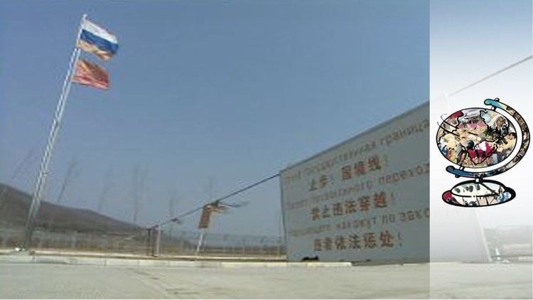
As with many other international borders, a bilateral treaty exists concerning the physical modalities of managing the China–Russia border. The currently valid agreement was signed in Beijing in 2006.
The treaty requires the two states to clear trees in a 15-meter wide strip along the border (i.e. within 7.5 meters from the border line on each side of it) (Article 6).
Civil navigation is allowed on the border rivers and lakes, provided the vessels of each country stay on the appropriate side of the dividing line (Article 9); similar rules apply to fishing in these waters (Article 10). Each country's authorities will carry out appropriate measures to prevent grazing livestock from crossing into the other country, and will endeavor to apprehend and return any livestock that straggles onto their territory from across the border (Article 17). Hunting using firearms is prohibited within 1000 m from the border line; hunters are prohibited from crossing the border in pursuit of a wounded animal (Article 19).
Detained illegal border crossers are supposed to be normally returned to their country of origin within 7 days from their apprehension (Article 34).
Eastern section
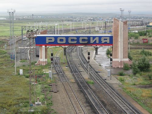
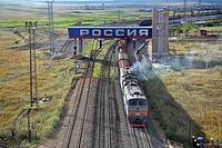
According to the Russia's border agency, as of October 1, 2013, there are 26 border crossings on the China–Russia border; all of them are located on the eastern section of the border. Twenty-five of them are provided for by the bilateral agreement of January 27, 1994, and one more is designated by an additional special order of the Russian government. The 25 crossing points established by the treaty include 4 railway crossings (at one of them, at Tongjiang/Nizhneleninskoye, the railway bridge is still under construction), 11 as highway crossings, 1 as river crossing, and 9 as "mixed" (mostly ferry crossings).
Presently, three railway lines cross the border. The two railway border crossings at Zabaikalsk/Manzhouli and Suifenhe/Grodekovo are over a century old, brought into existence by the original design of Russia's Transsiberian Railway that took a shortcut across Manchuria (the Chinese Eastern Railway). The third railway crossing, near Hunchun/Makhalino, operated between 2000-2004, was then closed for a few years, and only recently reopened. Construction has started on a cross-border Amur River railway bridge near Tongjiang/Nizhneleninskoye, which will become the fourth railway border crossing.
Western section
As of 2015, there were no border crossings of any kind on the two countries' short and remote western border section.
According to Russian topographic maps, the lowest mountain passes on the western section of the border are the Betsu-Kanas Pass (перевал Бетсу-Канас), elevation 2671.3 m. and Kanas (перевал Канас), elevation 2650 m. No roads suitable for wheeled vehicles exist over these two passes, although a difficult dirt road approaches from the Russian side to within 10 km from the Kanas Pass. Until the Soviet authorities closed the border in 1936, Kazakh nomads would occasionally use these passes.
Proposals exist for the construction of a cross-border highway and the Altai gas pipeline from China to Russia, which would cross the western section of the Sino-Russian border.