
Number of stations 145 | Number of lines 8 | |
 | ||
Daily ridership 767,730 (average weekday, 2015) | ||
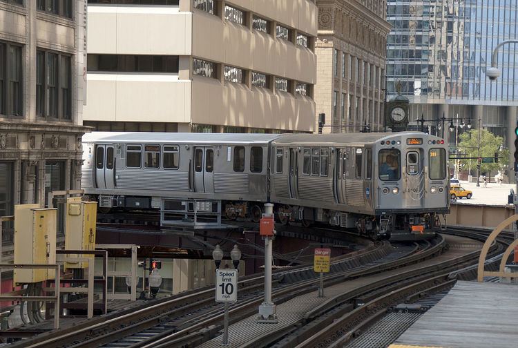
The Chicago "L" (short for "elevated") is the rapid transit system serving the city of Chicago and some of its surrounding suburbs in the U.S. state of Illinois. It is operated by the Chicago Transit Authority (CTA). It is the fourth largest rapid transit system in the United States in terms of total route length, at 102.8 miles (165.4 km) long, and the third busiest rail mass transit system in the United States after the New York City Subway and Washington Metro.
Contents
- Pre CTA era
- CTA assumes control
- Skip stop service
- New rolling stock
- The L today
- Renovation and expansion plans
- Recent service improvements
- Current capital improvements
- Planning future projects
- Circle Line
- Line extensions
- Possible future projects
- Lines
- Rolling stock
- Nickname
- Security and safety
- In popular culture
- References
Chicago's "L" provides 24-hour service on some portions of its network, being one of only five rapid transit systems in the United States to do so. (The others are the New York City Subway, Staten Island Railway, PATH, and Philadelphia's PATCO Speedline.) The oldest sections of the Chicago "L" started operations in 1892, making it the second oldest rapid transit system in the Americas, after New York City's elevated lines.
The "L" has been credited with fostering the growth of Chicago's dense city core that is one of the city's distinguishing features. The "L" consists of eight rapid transit lines laid out in a spoke–hub distribution paradigm focusing transit towards the Loop. Although the "L" gained its name because large parts of the system are elevated, portions of the network are also in subway tunnels, at grade level, or open cut.
In 2014, the "L" had an average of 752,734 passenger boardings each weekday, 486,267 each Saturday, and 359,777 each Sunday. In a 2005 poll, Chicago Tribune readers voted it one of the "seven wonders of Chicago," behind the lakefront and Wrigley Field but ahead of Willis Tower (formerly the Sears Tower), the Water Tower, the University of Chicago, and the Museum of Science and Industry.
Pre-CTA era
The first "L", the Chicago and South Side Rapid Transit Railroad, began revenue service on June 6, 1892, when a steam locomotive pulling four wooden coaches carrying over a couple of dozen people departed the 39th Street station and arrived at the Congress Street Terminal 14 minutes later, over tracks that are still in use by the Green Line. Over the next year service was extended to 63rd Street and Stony Island Avenue, then the Transportation Building of the World's Columbian Exposition in Jackson Park.
In 1893, trains began running on the Lake Street Elevated Railroad and in 1895 on the Metropolitan West Side Elevated, which had lines to Douglas Park, Garfield Park (since replaced), Humboldt Park (since demolished), and Logan Square. The Metropolitan was the United States' first non-exhibition rapid transit system powered by electric traction motors, a technology whose practicality had been demonstrated in 1890 on the "intramural railway" at the World Fair that had been held in Chicago. Two years later the South Side "L" introduced multiple-unit control, in which the operator can control all the motorized cars in a train, not just the lead unit. Electrification and MU control remain standard features of most of the world's rapid transit systems.
A drawback of early "L" service was that none of the lines entered the central business district. Instead trains dropped passengers at stub terminals on the periphery due to a state law at the time requiring approval by neighboring property owners for tracks built over public streets, something not easily obtained downtown. This obstacle was overcome by the legendary traction magnate Charles Tyson Yerkes, who went on to play a pivotal role in the development of the London Underground, and who was immortalized by Theodore Dreiser as the ruthless schemer Frank Cowperwood in The Titan (1914) and other novels. Yerkes, who controlled much of the city's streetcar system, obtained the necessary signatures through cash and guile—at one point he secured a franchise to build a mile-long "L" over Van Buren Street from Wabash Avenue to Halsted Street, extracting the requisite majority from the pliable owners on the western half of the route, then building tracks chiefly over the eastern half, where property owners had opposed him. The Union Loop opened in 1897 and greatly increased the rapid transit system's convenience. Operation on the Yerkes-owned Northwestern Elevated, which built the North Side "L" lines, began three years later, essentially completing the elevated infrastructure in the urban core although extensions and branches continued to be constructed in outlying areas through the 1920s.
After 1911, the "L" lines came under the control of Samuel Insull, president of the Chicago Edison electric utility (now Commonwealth Edison), whose interest stemmed initially from the fact that the trains were the city's largest consumer of electricity. Insull instituted many improvements, including free transfers and through routing, although he did not formally combine the original firms into the Chicago Rapid Transit Company until 1924. He also bought three other Chicago electrified railroads, the Chicago North Shore and Milwaukee Railroad, Chicago Aurora and Elgin Railroad, and South Shore interurban lines, and ran the trains of the first two into downtown Chicago via the "L" tracks. This period of relative prosperity ended when Insull's empire collapsed in 1932, but later in the decade the city with the help of the federal government accumulated sufficient funds to begin construction of two subway lines to supplement and, some hoped, permit eventual replacement of the Loop elevated. The construction of the Subway created the necessity to tunnel under the Chicago River.
The State Street Subway opened on October 17, 1943; the Dearborn Subway, on which work had been suspended during World War II, opened on February 25, 1951. The subways were constructed with a secondary purpose of serving as bomb shelters, as evidenced by the close spacing of the support columns (a more extensive plan proposed replacing the entire elevated system with subways). The subways bypassed a number of tight curves and circuitous routings on the original elevated lines (Milwaukee trains, for example, originated on Chicago's northwest side but entered the Loop at the southwest corner), speeding service for many riders.
CTA assumes control
By the 1940s the financial condition of the "L", and of Chicago mass transit in general, had become too precarious to permit continued operation without subsidies, and the necessary steps were taken to enable a public takeover. In 1947, the Chicago Transit Authority (CTA) acquired the assets of the Chicago Rapid Transit Company and the Chicago Surface Lines, operator of the city's streetcars. Over the next few years CTA modernized the "L", replacing wooden cars with new steel ones and closing lightly used branch lines and stations, many of which had been spaced only a quarter-mile apart.
Skip-stop service
Later, after assuming control of the "L", the CTA introduced an express service known as the A/B skip-stop service. Under this service, trains were designated as either "A" or "B" trains, and stations were alternately designated as "A" stations or "B" stations, with heavily used stations designated as both – "AB". "A" trains would only stop at "A" or "AB" stations, and "B" trains would only stop at "B" or "AB" stations. Station signage carried the station's skip-stop letter and was also color-coded by skip-stop type; "A" stations had red signage, "B" stations had green signage, and "AB" stations had blue signage. The system was designed to speed up lines by having trains skip stations while still allowing for frequent service at the heavily used "AB" stations. CTA first implemented A/B skip-stop service on the Lake Street Line (now part of the Green Line) in 1948, and the service proved effective as travel times were cut by a third. By the 1950s, the service was used throughout the system. All lines used the A/B skip-stop service between the 1950s and the 1990s with the exception of the Evanston and Skokie lines, which were suburban-only lines and did not justify skip-stop service. Also, the Congress and Douglas branches of what later became the Blue Line were designated as "A" and "B" respectively, as were the Englewood ("A") and Jackson Park ("B") branches of what later became the Green Line, so individual stops were not skipped while trains were serving those branches. As time went by, the time periods which employed skip-stop service gradually decreased, as the waits at "A" and "B" stations became increasingly longer during non-peak service. By the 1990s, use of the A/B skip-stop system was only used during rush hour service. Another problem was that trains skipping stations to save time still could not pass the train that was directly ahead, so skipping stations was not advantageous in all regards. In 1993, the CTA began to eliminate skip-stop service when it switched the southern branches of the Red and Green Lines to all stops. After this point, Green Line trains on the entire line stopped at all stations, and Red Line trains stopped at all stations south of Harrison. The elimination of A/B skip-stop service continued with the opening of the all-stop Orange Line and the conversion of the Brown Line to all-stop service. On April 28, 1995, the A/B skip-stop system was completely eliminated with the transfer of the O'Hare branch of the Blue Line and the Howard branch of the Red Line to all-stop service. The removal of skip-stop service resulted in some increases in travel times, and greatly increased ridership at former "A" and "B" stations.
New rolling stock
The first air-conditioned cars were introduced in 1964, the last pre-World War II cars were retired in 1973. New lines were built in expressway medians, a technique implemented in Chicago and followed by other cities worldwide. The Congress branch, built in the median of the Eisenhower Expressway, replaced the Garfield Park "L" in 1958. The Dan Ryan line, built in the median of the Dan Ryan Expressway, opened on September 28, 1969, followed by an extension of the Milwaukee elevated into the Kennedy Expressway in 1970.
The "L" today
At 102.8 miles (165.4 km), the Chicago "L" is the fourth largest heavy rail rapid transit system in the United States in terms of route mileage. It runs over a total of 224.1 miles (360.7 km) of track. Ridership had been remarkably stable for nearly 40 years after the CTA takeover despite declining mass transit usage nationwide, with an average of 594,000 riders boarding each weekday in 1960 and 577,000 in 1985. Due to the Loop Flood in 1992, ridership was at 418,000 that year because CTA was forced to suspend operation for several weeks in both the State and Dearborn subways, used by the most heavily traveled lines.
Ridership is healthy and growth continues, but it has not been uniformly distributed. Use of North Side lines is heavy and continues to grow, while that of West Side and South Side lines tend to remain stable. Ridership on the North Side Brown Line, for instance, has increased 83% since 1979, necessitating a station reconstruction project to accommodate even longer trains.
Annual traffic on the Howard branch of the Red Line, which reached 38.7 million in 2010 and 40.9 million in 2011, has exceeded the 1927 prewar peak of 38.5 million. The section of the Blue Line between the Loop and Logan Square, which serves once-neglected but now bustling neighborhoods such as Wicker Park, Bucktown, and Palmer Square, has seen a 54% increase in weekday riders since 1992. On the other hand, weekday ridership on the South Side portion of the Green Line, which closed for two years for reconstruction starting in 1994, was 50,400 in 1978 but only 13,000 in 2006. Boardings at the 95th/Dan Ryan stop on the Red Line, though still among the system's busiest at 11,100 riders per weekday (as of February 2015), are less than half the peak volume in the 1980s. In 1976, three North Side "L" branches – what were then known as the Howard, Milwaukee, and Ravenswood lines − accounted for 42% of non-downtown boardings. Today (with the help of the Blue Line extension to O'Hare), they account for 58%.
The North Side (which has historically been the highest density area of the city) skew no doubt reflects the Chicago building boom between 2000 and 2010, which has focused primarily on North Side neighborhoods and downtown. It may ease somewhat in the wake of the current high level of residential construction along the south lakefront. For example, ridership at the linked Roosevelt stops on the Green, Orange, and Red Lines, which serve the burgeoning South Loop neighborhood, has tripled since 1992, with an average of 8,000 boardings per weekday. Patronage at the Cermak-Chinatown stop on the Red Line (4,000 weekday boardings) is at the highest level since the station opened in 1969. The 2003 Chicago Central Area Plan proposed construction of a Green Line station at Cermak, midway between Chinatown and the McCormick Place convention center, in expectation of continued density growth in the vicinity. This station opened in 2015.
As of mid-2006, the "L" accounted for 36% of the CTA's nearly 1.5 million weekday riders, with the remainder traveling on the extensive bus network. The rail system's ridership has increased over time. In 1926, the year of peak prewar rail usage, the "L" carried 229 million passengers – seemingly a formidable number, but actually less than 20% of the 1.16 billion Chicago transit patrons that year, most of whom rode the city's streetcars. The shift to rail has continued in recent times. Since its low point in 1992 due to the Chicago Flood that closed subway tunnels in the downtown area, weekday "L" ridership has increased about 25%, while bus ridership has decreased by roughly a sixth.
Currently, with two exceptions, all lines operate at all times except late nights. The exceptions are the Red Line and the Blue Line. which operate 24/7. Prior to 1995, the Brown Line and the Green Line also had 24 hour service. In the years of private ownership, the South Side Elevated Railroad (now the South Side Elevated portion of the Green Line) provided 24 hour service, a major advantage when compared to Chicago's cable railroads which required daily overnight shutdown for cable maintenance.
As of 2015, the "L" uses a flat fare of $2.25 for almost the entire system, the only exception being O'Hare International Airport on the Blue Line, at which passengers entering the station are charged a higher fare of $5.00 (passengers leaving the system at this station are not charged this higher fare). The higher fare is being charged for what the CTA considers "premium-level" service to O'Hare. Use of the Midway International Airport Station does not require this higher fare; it only requires the $2.25 regular fare. The higher charge at O'Hare has been the source of some controversy in recent years, because of the CTA's plan to eliminate the exemption from the premium fare for airport workers, Transportation Security Administration workers, and airline workers. After protests from those groups, the CTA extended the exemptions for six months.
Renovation and expansion plans
The CTA's current capital improvement spending is focused on the Brown Line Capacity Expansion Project, Slow Zone Elimination, and the rehabilitation of the Red Line. In 2012 the CTA reopened the Green Line's Morgan station, and the Village of Skokie reopened the Yellow Line's Oakton station. Both stations were closed in 1948 after the CTA was created, and the original stations were demolished soon after.
The CTA is also actively studying a number of proposals for expanding "L" rail service, including the Circle Line and extensions to the Red, Orange, and Yellow Lines. The State's capital budget proposal for fiscal year 2010 includes funding for "preliminary engineering" on the planned Circle Line, as well as funds for modernizing and replacing the system's aging railcars.
In addition, CTA has studied numerous other proposals for expanded rail service, some of which may be implemented in the future.
Recent service improvements
Pink Line service began on June 25, 2006, though it did not involve any new tracks or stations. The Pink Line travels over what was formerly a branch of the Blue Line from the 54th/Cermak terminal in Cicero to the Polk station in Chicago. Pink Line trains then proceed via the Paulina Connector to the Lake Street branch of the Green Line and then clockwise around the Loop elevated via Lake-Wabash-Van Buren-Wells. (Douglas trains used the same route between April 4, 1954 and June 22, 1958 after the old Garfield Park "L" line was demolished to make way for the Eisenhower Expressway.) The new route, which serves 22 stations, offers more frequent service for riders on both the Congress and Douglas branches. Pink Line trains can be scheduled independently of Blue Line trains, and run more frequently than the Douglas branch of the Blue Line did.
The Brown Line Capacity Expansion Project enabled CTA to run eight-car trains on the Brown Line, and rebuilt stations to modern standards, including handicap accessibility. Before the project, Brown Line platforms could only accommodate six-car trains, and increasing ridership led to uncomfortably crowded trains. After several years of construction, eight-car trains began to run at rush hour on the Brown Line in April 2008. The project was completed at the end of 2009, on time and on budget, with only minor punch list work remaining. The project’s total cost is expected to be around $530 million.
One of the largest reconstruction projects in the CTA's history, at a cost of $425 million, was the Red Line South reconstruction project. From May 19, 2013 through October 20, 2013, the project shut down and rebuilt the entire Red Line South — replacing and rebuilding all the tracks, ties, ballast and drainage systems — from Cermak-Chinatown to 95th/Dan Ryan. The station work involved renewing and improving eight stations, including painting and lighting, bus bridge improvements, and new roofs and canopies at some stations. "We are looking forward to providing our south Red Line customers with improved stations that are cleaner, brighter and better than they have been in years," said CTA President Forrest Claypool.
Current capital improvements
CTA’s Slow Zone Elimination Project continues. In late 2007, trains were forced to operate at reduced speed over more than 22% of the system due to deteriorated track, structure, and other problems. By October 2008, system-wide slow zones had been reduced to 9.1% and by January 2010, total slow zones were reduced to 6.3%. The Loop received track work in 2012-2013. The Purple Line in Evanston received track work and viaduct replacement in 2011-2013. The Green Line Ashland branch received track work in 2013, prior to the Red Line Dan Ryan reconstruction.
As of 2014, the CTA is investing in station and track upgrades on the Blue Line between Grand and O'Hare. This four year, $492 million project, will result in modernized stations (some of which were originally built in 1895), rebuilt track, faster service between O'Hare and the Loop, station platform replacement, subway water management, subway station water infiltration remediation, and improved access to some stations (by adding elevators).
4G wireless coverage will be added to the Blue Line and Red Line subways, with the $32.5 million installation cost paid for by T-Mobile, Sprint, AT&T and Verizon.
Planning future projects
All of the new rail service proposals under active consideration by CTA are currently undergoing Alternatives Analysis Studies.
These studies are the first step in a five-step process. This process is required by the Federal New Starts program, which is an essential source of funding for CTA’s expansion projects. CTA uses a series of "Screens" to develop a "Locally Preferred Alternative," which is submitted to the federal New Starts program.
It will likely be years before any of these projects is completed, as no project yet has a definite source of funding.
Circle Line
The proposed Circle Line would form an "outer loop", traversing downtown via the State Street subway, then going southwest on the Orange Line and north along Ashland, before re-joining the subway at North/Clybourn or Clark/Division. The Circle Line would connect several different Metra lines with the "L" system, and would facilitate transfers between existing CTA lines; these connections would be situated near the existing Metra and "L" lines' maximum load points. CTA initiated official "Alternatives Analysis" planning for the Circle Line in 2005.
Early conceptual planning divided the Circle Line into three segments. Phase 1 would be a restoration of the dilapidated "Paulina Connector", a short (0.75 mi/1.2 km) track segment that links Ashland/Lake with Polk. This track section has since been restored when service on the 54th/Cermak branch was transferred to the Pink Line. Phase 2 would link 18th on the Pink Line to Ashland on the Orange Line, with a new elevated structure running through a large industrial area. Phase 3, the final phase, would link Ashland/Lake to North/Clybourn with a new subway running through the dense neighborhoods of West Town and Wicker Park. Although the general alignment of Phase 2 was decided upon at an early date, Phase 3 will run through dense residential areas, so the alignment must be considered carefully to avoid adversely impacting those neighborhoods. CTA continues to study various possibilities for the alignment of Phase 3.
Phase 1 was completed in 2005 with the restoration of the Paulina Connector. In 2006, the Connector was placed into service as part of the new Pink Line. In 2009, CTA released the results of its Alternatives Analysis Screen 3, in which it decided to begin early engineering work on Phase 2, due to its simple alignment through unpopulated areas and its relatively low cost (estimated at $1.1 billion). Phase 3, which CTA estimates will be far more costly due to its underground alignment, will remain under study until further notice.
Preliminary engineering work is now being performed on Phase 2. In addition to the new line, CTA plans to build four new stations as part of Phase 2, although three out of the four will be located along existing lines that the Circle Line will utilize. These will be at 18th/Clark, Cermak/Blue Island, Roosevelt/Paulina, and Congress/Paulina. 18th/Clark will be along the Orange Line in the Chinatown neighborhood, and will include a direct transfer connection to the Cermak/Chinatown station on the Red Line. Cermak/Blue Island will be located on the newly built elevated tracks in the Pilsen neighborhood. Roosevelt/Paulina will be located on the Pink Line in the Illinois Medical District. Finally, Congress/Paulina will be built above the Eisenhower Expressway, with a direct transfer connection to the Illinois Medical District station on the Blue Line. Existing stations will provide service near the United Center.
Line extensions
CTA is conducting Alternatives Analysis Studies of proposed extensions for the Red, Orange and Yellow Lines. Although these are three separate projects in three different areas of the city and suburbs, all three projects involve similar challenges of extending existing lines into underserved areas, so CTA has chosen to group the lines together into a larger program, so that analysis, engineering, and construction work can be done more cost-effectively through economies of scale.
Red Line extension
An extension of the Red Line would provide service from the current terminus, at 95th Street, to 130th Street, decreasing transit times for residents of the far South Side and relieving crowding and congestion at the current terminus. CTA presented its locally preferred alternative at meetings in 2009. This consists of a new elevated rail line between 95th St and a new terminal station at 130th, paralleling a Union Pacific Railroad line through the Far South Side neighborhoods of Roseland, West Pullman, and Riverdale. In addition to the terminal station at 130th, three new stations would be built at 103rd Street, 111th Street, and 115th Street/Michigan Avenue. Basic engineering, along with an environmental impact statement, were underway in 2010. Alignment commenting was open in 2016, and alignment decisions expected in 2017.
Orange Line extension
An extension of the Orange Line would provide transit service from the current terminus, Midway International Airport, to the Ford City Mall, which was originally meant to be the Orange Line's southern terminus when the line was planned in the 1980s. This would alleviate congestion at the current Midway terminal. CTA presented its locally preferred alternative at meetings in 2009. This consists of a new elevated rail line that runs south from the Midway terminal along Belt Railway tracks, crosses Clearing Yard while heading southwest to Cicero Avenue, then runs south in the median of Cicero to a terminal on the east side of Cicero near 76th Street. Basic engineering, along with an environmental impact statement, were underway in 2010.
Yellow Line extension
An extension of the Yellow Line would provide transit service from the current terminus, at Dempster Street, to the corner of Old Orchard Road and the Edens Expressway, just west of the Westfield Old Orchard shopping center. CTA presented its locally preferred alternative at meetings in 2009. This consists of a new elevated rail line from Dempster north along a former rail right-of-way to the Edens Expressway, where the line will turn to the north and run along the east side of the expressway to a terminus at Old Orchard Road. Basic engineering, along with an environmental impact statement, were underway in 2010. Unlike extensions to the Red and Orange Lines, the Yellow Line Extension has attracted significant community opposition from residents of Skokie, as well as parents of students at neighboring Niles North High School, on whose land the new line would be constructed. Residents and parents have cited concerns about noise, visual pollution, and crime. It is expected that these concerns will be addressed in the environmental impact statement.
Possible future projects
There are other possible future expansions, identified in various city and regional planning studies. CTA has not begun official studies of these expansions, so it is unclear whether they will ever be implemented, or simply remain as visionary projects. They include:
Numerous plans have been advanced over the years to reorganize downtown Chicago rapid transit service, originally with the intention of replacing the elevated Loop lines with subways. That idea has been largely abandoned as the city seems keen on keeping an elevated/subway mix. But there have been continued calls to improve transit within the city's greatly enlarged central core. At present the "L" does not provide direct service between the Metra commuter rail terminals in the West Loop and Michigan Avenue, the principal shopping district, nor does it offer convenient access to popular downtown destinations such as Navy Pier, Soldier Field, and McCormick Place. Plans for the Central Area Circulator, a $700 million downtown light rail system meant to remedy this, were shelved in 1995 for lack of funding. An underground line running along the lakeshore would connect some of the city's major tourist destinations, but this plan has not been widely discussed. Recognizing the cost and difficulty of implementing an all-rail solution, the Chicago Central Area Plan advocated a mix of rail and bus improvements, the centerpiece of which was the West Loop Transportation Center, a multi-level subway to be constructed under Clinton Street from Congress Parkway to Lake Street. The top level would be a pedestrian mezzanine, buses would operate in the second level, rapid transit trains in the third level, and commuter/high-speed intercity trains in the bottom level. The rapid transit level would connect to the existing Blue Line subway at its north and south ends, making possible the "Blue Line loop," envisioned as an underground counterpart to the Loop elevated. Alternatively, this level might be occupied by the Clinton Street Subway. Among other advantages, the West Loop Transportation Center would provide a direct link between the "L" and the city's two busiest commuter rail terminals, Ogilvie Transportation Center and Union Station. The plan also proposed transitways along Carroll Avenue (a former rail right-of-way north of the main branch of the Chicago River) and under Monroe Street in the Loop, which earlier transit schemes had proposed as rail routes. The Carroll Avenue route would provide faster bus service between the commuter stations and the rapidly redeveloping Near North Side, with possible rail service later. These new busways would tie into the bus level of the West Loop Transportation Center.
Lines
Since 1993 "L" lines have been officially identified by color, although older route names survive to some extent in CTA publications and popular usage to distinguish branches of longer lines:
Rolling stock
The CTA operates over 1,350 "L" cars, divided among three series, some of which are permanently coupled into married pairs. All cars on the system utilize 600 volt direct current power delivered through a third rail. The new 5000-series cars are equipped with alternating current propulsion systems and have inverters on board to convert the DC power to AC power. The older cars use DC motors.
The 2600-series was built from 1981 until 1987 by the Budd Company of Philadelphia, Pennsylvania. After the completion of the order of the 2600-series cars, Budd changed its name to Transit America and ceased production of railcars. With 503 cars in operation, the 2600-series is the largest of the three series of "L" cars in operation, The cars were rebuilt by Alstom of Hornell, New York from 1999 until 2002.
The 3200-series, was built from 1992 until 1994 by Morrison-Knudsen of Hornell, New York. These cars have fluted, stainless steel sides similar to the now-retired 2200-series.
The newest series of train cars, the 5000-series, feature AC propulsion, security cameras, and aisle-facing seating.
Nickname
The Chicago rapid-transit system is officially nicknamed the "L". This name for the CTA rail system applies to the whole system: its elevated, subway, at-grade, and open-cut segments. The use of the nickname dates from the earliest days of the elevated railroads. Newspapers of the late 1880s referred to proposed elevated railroads in Chicago as "'L' roads." The first route to be constructed, the Chicago and South Side Rapid Transit Railroad gained the nickname "Alley Elevated", or "Alley L" during its planning and construction, a term that was widely used by 1893, less than a year after the line opened.
In discussing various stylings of "Loop" and "L" in Destination Loop: The Story of Rapid Transit Railroading in and around Chicago (1982), author Brian J. Cudahy quotes a passage from The Neon Wilderness (1949) by Chicago author Nelson Algren: "beneath the curved steel of the El, beneath the endless ties." Cudahy then comments, "Note that in the quotation above ... it says 'El' to mean 'elevated rapid transit railroad.' We trust that this usage can be ascribed to a publisher's editor in New York or some other east coast city; in Chicago the same expression is routinely rendered 'L'."
As used by CTA, the name is rendered as the capital letter 'L', in single quotation marks. "L" (with double quotation marks) was often used by CTA predecessors such as the Chicago Rapid Transit Company; however, the CTA uses single quotation marks (') on some printed materials and signs rather than double. In Chicago, the term "subway" is only applied to the sections of the Red and Blue Lines that are actually underground and is not applied to the entire system as a whole, as in New York City where both the elevated and underground portions make up the New York City Subway.
Security and safety
The CTA rail cars have generally been secure and safe but in addition to general security issues on the CTA, there were calls to improve CTA's emergency response and communications procedures. CTA has also had incidents where operators apparently overrode automatic train stops on red signals, such as the 1977 collision at Wabash and Lake, when four cars of a Lake-Dan Ryan train fell from the elevated structure, killing 11, and two minor incidents in 2001, and two more in 2008, the more serious involving a Green Line train that derailed and straddled the split in the elevated structure at the 59th Street junction between the Ashland and East 63rd Street branches, and a minor one near 95th Street on the Red line.
In 2002, 25-year-old Joseph Konopka, self-styled as "Dr. Chaos", was arrested by Chicago police for hoarding potassium cyanide and sodium cyanide in a Chicago Transit Authority storeroom in the Chicago "L" Blue Line subway. Konopka had picked the original locks on several doors in the tunnels, then changed the locks so that he could access the rarely used storage rooms freely.
In popular culture
Movies and television shows use establishing shots to orient audiences to the location. For media set in Chicago, the "L" is a common feature because it is such a distinctive part of the city. Some of the more prominent films which have used such setup footage include The Fugitive (1993), which also contained a short scene inside of an "L" train, The Sting (1973), and The Blues Brothers (1980). Running Scared (1986) shows a car chase taking place on the "L" tracks. The sounds of the "L" are also distinctive and are therefore also used to establish location. Risky Business (1983) features the "L" in several erotic sequences. The "L" is also featured in Planes, Trains and Automobiles (1987) and Code of Silence (1985). The line is part of the main plot device in While You Were Sleeping (1995) in which Lucy works as an "L" fare collector. Dick Wolf's Chicago franchise of television shows are set in and filmed on site in the eponymous city, and feature the "L" in various episodes.