
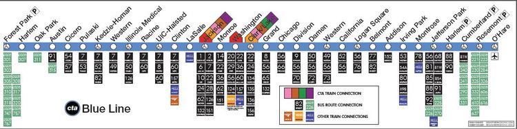
Status Operational Stations 33 | Character Rapid transit | |
 | ||
Daily ridership 186,796(avg. weekday September 2012) Opened February 21, 1993 (Current operation) | ||
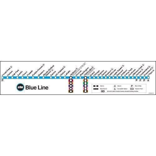
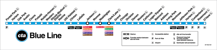
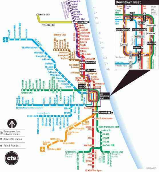
The Blue Line, also known as the O'Hare-Congress Line and the West-Northwest Line, is a 26.93-mile (43.34 km) long Chicago "L" line which extends through the Loop from O'Hare International Airport at the far northwest end of the city, through downtown via the Milwaukee-Dearborn Subway and across the West Side to its southwest end at Forest Park, with a total of 33 stations. It is the CTA's second busiest rail line, with an average of 186,796 passengers boarding each weekday in September 2012.
Contents
- History
- OHare Branch
- Milwaukee Dearborn Subway
- Congress Branch
- Douglas Branch
- Rolling stock
- Accidents and incidents
- Line extensions
- Extra tracks
- Stub tunnels
- References
The Blue Line and Red Line are the only two routes of the Chicago "L" system to currently run 24 hours a day and is one of only six rapid transit rail systems in the United States to do so (the others being the PATCO Speedline, Staten Island Railway, the PATH lines, Philadelphia's SEPTA and the New York City Subway). The Blue Line is also one of only two lines with more than one station with the same name, with the Green Line being the other (It has two stations at Harlem Avenue: one in the Kennedy Expressway on the Northwest side and one on the south side of the Eisenhower Expressway in Forest Park, Illinois. It also has two stations on Western Avenue: one on the O'Hare branch and one on the Congress branch). The Blue Line also has only three in-system transfers (all in the Loop), contains a combination of both the oldest and newest portions of 'L' tracks, and does not share tracks with any other 'L' line.
Before the adoption of color-coded names, the Blue Line was referred to as the West-Northwest Route (which it is still sometimes referred to as today) or more commonly, the O'Hare-Congress-Douglas route for its three branches. The Congress and Douglas branches were renamed for their terminals, Forest Park and 54th/Cermak, when the current color naming system was adopted in 1993. Blue Line service on the Douglas Branch was discontinued in April 2008 and replaced by the Pink Line.
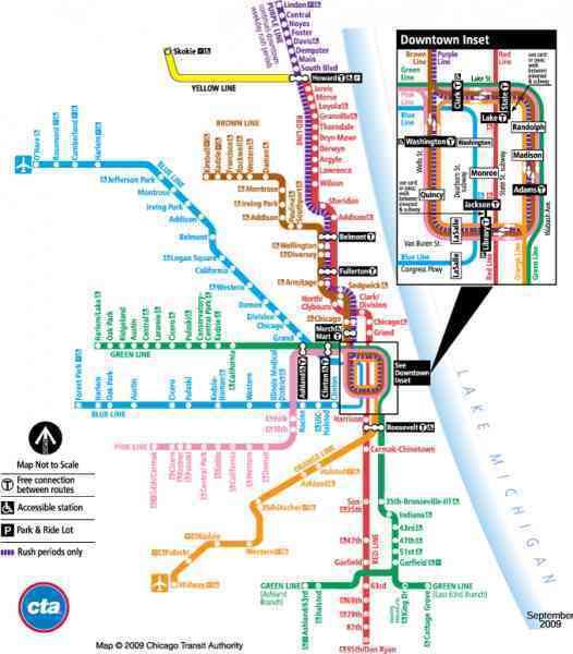
The Blue Line is one of five 'L' lines that run into Chicago suburbs, with the others being the Green, Purple, Pink, and Yellow lines. The Blue, Green, and Purple Lines are the only three rail lines that run through more than one suburb, with the Green and Purple Lines running through two, but the Blue Line actually runs through three, making it the rail line that runs through the most suburbs on the Chicago 'L' system.
History
The most vintage components of the Blue Line began as part of the Metropolitan West Side Elevated Railroad in 1895. The first section to be built by the Met extended west in the vicinity of Van Buren Street from an independent terminal at Canal and Jackson Streets to Marshfield Avenue, and then northward in the vicinity of Paulina Street to Damen and Milwaukee Avenues. Service on this section began on May 6, 1895. The structure was completed from Damen Avenue to Logan Square on May 25, 1895.
The next stage in the development of the West Side 'L' came on June 19, 1895, when the Garfield Park Branch was added, extending west in the vicinity of Van Buren Street and Harrison Street from Marshfield Avenue to Cicero Avenue. An extension of service over the tracks of the Aurora, Elgin and Chicago Railroad to a new terminal at Desplaines Avenue was established on March 11, 1905. A subsequent extension to Westchester opened on October 1, 1926. (Low ridership would prompt the CTA to discontinue service on the Westchester extension on December 9, 1951.)
Another branch line was added to the rapidly growing Metropolitan System on July 29, 1895, when trains began operating over the Humboldt Park Branch, paralleling North Avenue from Damen Avenue to a terminal at Lawndale Avenue. (The route was discontinued on May 3, 1952.) This was followed by still another addition when the Douglas Park Branch was placed in operation as far south as 18th Street on April 28, 1896.
As the southwest area of the city developed, the Douglas Park Branch was extended from 18th Street to Western Avenue in September 1896; to Pulaski Road in June, 1902; to Cicero Avenue in December 1907; to Central Avenue in August, 1912; to 62nd Avenue in August, 1915, and to Oak Park Avenue in Berwyn on March 16, 1924. The Douglas Park branch was later cut back to 54th Avenue in Cicero, Illinois.
The Metropolitan West Side Elevated began service onto the Loop on October 11, 1897, and a rush period stub terminal at Wells Street was added October 3, 1904. For much of the early 20th century and through the 1940s, service on the West Side Elevated lines went unchanged until the Chicago Transit Authority took control of Chicago's Rapid Transit System on October 1, 1947, initiating a series of massive service cuts and station closings (that would last until the 1980s).
On February 25, 1951, the CTA opened the Milwaukee-Dearborn Subway, connecting the Milwaukee Avenue elevated route (formerly Logan Square) with the Loop on a fast, efficient and more direct routing through the heart of the city. With opening of the Dearborn Subway, the old elevated alignment between Evergreen and Marshfield Avenues was decommissioned, used only for moving out-of-service rail cars. The north section of this connection between Evergreen Avenue and Lake Street was subsequently demolished in the 1960s, leaving the Lake Street Branch-to-Douglas Branch section or the "Paulina Connector" still in existence.
The Garfield Park elevated was replaced by the Congress line on June 22, 1958, pioneering the world's first use of rail rapid transit and a multi-lane automobile expressway in the same grade-separated right-of-way. (Pacific Electric Railway "Red Car" tracks ran in the median of the Cahuenga Parkway in Los Angeles from 1944 until its expansion into the Hollywood Freeway in 1952, but the Pacific Electric service was an interurban streetcar rather than true rapid transit.) The new line connected with the Milwaukee-Dearborn Subway at the Chicago River and extended westward to Des Plaines Avenue in Forest Park. Loomis Ramp, built at this same time, permitted Douglas trains to operate through the subway as well combining the Logan Square, Garfield Park (now Congress) and Douglas routes into the second through service in Chicago, the West-Northwest route.
A five-mile (8 km) extension of the route via the short subway connection and the Kennedy Expressway median from Logan Square to Jefferson Park opened on February 1, 1970. It was also built by the City of Chicago using federal money. From Logan Square, trains veer off of the old elevated structure and enter the subway under Milwaukee and Kedzie Avenues to a portal just south of Addison Street, then continue northwest in the median of the Kennedy Expressway to the temporary terminal at Jefferson Park. In March 1980, construction began on the O'Hare Airport extension of the Kennedy route between Jefferson Park and the airport. The first section between Jefferson Park and Rosemont was placed in service on February 27, 1983, and the final section to O'Hare on September 3, 1984.
On February 21, 1993, the CTA adopted a color-coded naming system to the rapid transit system, and the West-Northwest route (OHare-Congress/Douglas) became the Blue Line. On April 26, 1998, the Douglas Branch lost its overnight (owl) and weekend service and began operating between 4 a.m. and 1 a.m. on weekdays only as a result of funding shortages requiring CTA to cut services. Congress (Forest Park) service was effectively doubled through much of the day since service frequency from O'Hare required shorter headways than what would have been left.
Reasons for the Douglas Branch service reduction were due to its low ridership, badly deteriorated infrastructure and funding problems, while many residents in the communities it runs through had claimed that it was just another attempt by the CTA to eliminate transit service on the West Side.
On September 10, 2001, the CTA began a historic reconstruction of the Douglas Branch to repair its aging stations and tracks. The work was officially completed on January 8, 2005 with new elevated structures, tracks, stations, new communication networks and an upgraded power system along the route. On January 1, 2005, weekend service was restored.
In January 2005, the CTA held hearings on a proposal to reroute much of the Douglas Branch service via the recently rebuilt Paulina Connector to the Lake Street Green Line, carrying Douglas trains to and around the elevated Chicago Loop (clockwise) for the first time since Douglas trains began using the Milwaukee-Dearborn Subway in downtown Chicago in 1958. It was the first stage of what became the Pink Line. This would have allowed a doubling of Blue Line trains to Forest Park on the Congress Branch, since service would no longer be divided between the Forest Park and 54th/Cermak terminals. Due to community fears that the Pink Line would not be enough, however, the CTA decided to retain limited Douglas Branch Blue Line service during weekday rush hours.
On February 15, 2006, the CTA approved the separate operation of the Douglas Branch plan. All non-rush hour trains would all be routed via the Loop, Green Line and Paulina Connector. During rush hour, service was available on the new route as well as the existing route via the Milwaukee-Dearborn Subway. These changes were scheduled to be implemented for a 180-day trial period beginning June 25, 2006 and after their evaluation in early 2007, the Pink Line remained in service.
Beginning April 28, 2008, the CTA began a six-month experimental ceasing of Blue Line operations on the Douglas Despite maintaining that the service cut was an experiment, the CTA covered Blue Line stations' directional signage for trains to 54th/Cermak with paint rather than temporary covering, suggesting it was a permanent discontinuation instead of a temporary one. All Douglas Branch operations are now served by the Pink Line. On December 4, 2008, CTA announced its decision to permanently discontinue Blue Line service on the Douglas branch and to make the Pink Line permanent.
On October 15, 2015, the CTA announced that they now have full 4G wireless service on the Blue Line in between the Logan Square and Belmont stations. In the future this will mean that the CTA will be the largest rapid transit system with 4G coverage in subway tunnels and stations, this is targeted for the end of 2015.
O'Hare Branch
The O'Hare Branch is the longest section of the Blue Line (14.6 miles (23.5 km)) and comprises both the oldest and newest segments of the entire route. The line starts at O'Hare International Airport in an underground station below the main parking garage, servicing Terminals 1, 2, and 3. The line emerges in the median of the O'Hare main access road (Interstate 190) just northwest of Terminal 5, about a mile (1.6 km) west of Mannheim Road. The line runs in the median of Interstate 190 east through Rosemont. The line has a stop at Rosemont, which is also the location of one of the line's two storage yards, then tunnels beneath the Kennedy Expressway/Northwest Tollway interchange near the Des Plaines River. From here to just south of Addison Street, the line runs in the median of the Kennedy Expressway (Interstate 90) east and southeast towards the city. South of Addison Street, the line dives into a subway. The line travels under Kimball Avenue and Milwaukee Avenues through Logan Square. South of Logan Square, the line emerges above ground onto an elevated structure parallel to Milwaukee Avenue. This section of structure, built in 1895 as part of the Metropolitan Elevated, is the oldest portion of the Blue Line's infrastructure, and the sole section of the line on an elevated viaduct.
Milwaukee-Dearborn Subway
At the intersection of Ashland and Milwaukee Avenues, the Blue Line descends underground, swings over to Milwaukee Avenue, and continues southeast towards downtown under Milwaukee Avenue (with stops at Division Street, Chicago Avenue and Grand Street), east under Lake Street (crossing beneath the Chicago River) (with a stop at Clark/Lake Streets), south under Dearborn Street through the Loop (with stops at Washington Street, Monroe Street, and Jackson Boulevard) and west under Congress Parkway (with stops at LaSalle Street and Clinton Street). The tracks emerge from a portal near Halsted Street in the median of the Eisenhower Expressway (Interstate 290) and continue west. Jackson provides a transfer tunnel to the Red Line. Until October 2006, a transfer tunnel existed at Washington as well.
A downtown superstation has been proposed to provide express service from the Loop to both O'Hare and Midway Airports, via the Blue and Orange Lines respectively. The station would provide services such as baggage check. However, budget issues plague the operation and have prevented construction.
Congress Branch
After exiting the subway, the tracks continue west in the median of the Eisenhower Expressway as the Congress Branch. Immediately west of the Racine station, the Congress tracks diverge to permit a ramp up to the Douglas Branch elevated structure. This ramp was formerly used in revenue service when the Blue Line operated over the Douglas branch as well as the Congress branch. With the replacement of Douglas branch Blue Line service with the Pink Line, the ramp is now non-revenue trackage, and the only connection between the Blue Line's tracks and the rest of the system. The Congress Branch remains in the median of the expressway through the west side of Chicago until it reaches a portal at Lotus. At this point the tracks tunnel beneath the eastbound expressway lanes and before emerging on the south side of the expressway next to the Baltimore and Ohio Chicago Terminal Railroad (CSX) tracks. The route passes through Oak Park and into Forest Park. In the vicinity of Desplaines Avenue the tracks rise and make an S-curve north over the expressway before terminating at a station on the west side of Desplaines Avenue.
Douglas Branch
The Douglas Branch begins at 54th Avenue and Cermak Road in Cicero. The line runs east on street level right-of-way just north of and parallel to Cermak Road from the terminal to about a quarter-mile (400 m) east of Cicero Avenue, then diagonals northeast until it reaches a corridor parallel and adjacent to 21st Street at Kostner Avenue. It then continues east between 21st Street and Cullerton Street, climbing up from surface level to elevated structure, through the North Lawndale, Little Village, and Pilsen neighborhoods of Chicago, with stops at Kostner, Pulaski, Central Park, Kedzie, California, Western and Damen. The line turns north near Paulina Street stopping at 18th and Polk Streets then curves east over the Eisenhower Expressway (Interstate 290). The Douglas tracks ramps down to the surface of the median of the expressway and joins the Congress (Forest Park) Branch just before the Racine station. On April 28, 2008, the CTA eliminated Blue Line service on the Douglas branch, having been replaced by the Pink Line.
Rolling stock
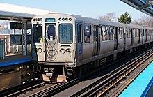
The Blue Line is operated with the 2600-series railcars. Trains operate using eight cars on weekdays and weekends, while four-car trains operate during late nights and early mornings. The 2600-series cars are expected to remain in service on the line until around 2024 when the base order of 400 future 7000-series cars enter service to replace the entire fleet of the 2600-series cars.
Accidents and incidents
On July 11, 2006, a derailment caused a smokey fire in the Blue Line's Milwaukee-Dearborn Subway. There were injuries from smoke inhalation, but no fatalities. The comparatively minor incident prompted heavy news coverage and a temporary stoppage of Chicago subway service because it occurred hours after train bombings in Mumbai earlier the same day.
On September 30, 2013, two Blue Line trains collided at Harlem (Congress Branch), injuring 33 people, after an outbound train was hit by an out-of-service train going the opposite direction on the same track. Earlier, the train had arrived at Forest Park, and went out of service. However, after the train pulled into the Desplaines Yard, it was left on. There were no passengers on the out-of-service train; the number of workers on it at the time of the crash was also an unknown. Also unknown was the total number of passengers on the outbound, in-service train. The investigation started shortly thereafter. Though service soon went back to normal, trains did not stop at the Harlem station until the late evening on Tuesday, October 1 to avoid interference with the scene and congestion.
In the early morning of March 24, 2014, a Blue Line train derailed at O'Hare at the end of its run. Initial reports said that 32 passengers on the train were injured, but none of the injuries were considered life-threatening. The station reopened on Sunday, March 30, 2014 at 2:00 p.m.
Line extensions
For the past twenty years, there had been talk of extending the O'Hare section of the Blue Line westward to Schaumburg, but this has recently been changed with the recent developments involving the planning of the Metra STAR Line and various other transportation projects.
However, in 2008, the Regional Transit Authority revealed a plan to possibly expand commuter rail and bus service to the RTA board, which included a 13.3 miles (21.4 km) extension of the Blue Line on an east-west route from its current western terminus at Forest Park to as far west as the Yorktown shopping center in DuPage County. Several feeder bus routes would also be implemented along the route in order to supplement ridership and increase usefulness. The prospect of this extension was also listed in the Chicago region's 2030 long-term master plan.
In early 2013, the idea of an infill station at Nagle and Bryn Mawr Avenues was declined. For now such a station is strictly an idea but it may come to existence in the future since that particular stretch of the line between Jefferson Park and Harlem is the second longest on the 'L' system without a station (behind the gap on the Yellow Line between Oakton-Skokie and Howard).
Extra tracks
The surface right-of-way for the Congress Branch, including overcrossings, undergrade bridges and two short tunnels under the expressway, contains space for one extra track between Forest Park and Kenton Avenue and two extra tracks from Kenton to the tunnel portals at UIC-Halsted. It was intended that the interurban Chicago Aurora and Elgin Railroad, which had utilized the Garfield Park Elevated until 1953 to reach its Loop terminal at Wells Street, would use these extra tracks. However, the CA&E ceased passenger service abruptly on July 3, 1957, never to resume, before track construction had started. The CTA also considered plans of its own to add these as express tracks (and service) over the years, as well as a rerouting of the Lake Elevated onto the Paulina Elevated (today's Pink Line) into a new quadrant of the junction with the Douglas Line at Racine, but these plans also never came to existence.
Stub tunnels
The dual portals of the Congress Branch at UIC-Halsted are actually quadruple; two extra portals also exist to the north of the Blue Line portals, which extend only a few hundred feet beyond the portals, These were intended to accommodate future expansion, including a new CA&E line to a new terminal, or for a variety of later CTA new line proposals which were never realized. Among those plans were a loop subway system via Congress, Dearborn, Lake, and Clinton when the Milwaukee-Dearborn-Congress Subway was completed between 1951–58; a shuttle subway route under Jackson Street to Grant Park (1958 New Horizons for Chicago Metropolitan Area, CTA); and more recently between 1968-78 in the form the Distributor Subway system which was to be routed from UIC-Halsted Station through the north portals, then north under Desplaines Street to Monroe Street and east under Monroe Street to Grant and Millennium Park where it was to split into two branches: one north to Walton Street serving the North Michigan Avenue area and the other southeast to McCormick Place utilizing Metra Electric right-of-way. Though these portals are still not used, the Monroe Street Distributor Subway was never "officially" cancelled when the Crosstown and Loop Subway projects were deferred in 1979. It remains to this day an active program.
Between Grand/Milwaukee and Clark/Lake in the Milwaukee-Dearborn Subway, two more stub tunnels also exist, continuing straight while the current Blue Line heads in the northwest direction. This junction (actually a stacked junction), built in the 1940s along with the subway, was intended for a never-built connection to, or subway replacement of the Lake Street Elevated. In the late 1960s through the mid-1970s, they were also proposed to be a service link between the Dearborn Subway and a high-speed subway route in Randolph Street to replace a portion of the Lake Street 'L' east of Damen Avenue (Transit Planning Study Chicago Central Area, April 1968).