
Population 30,635 2011 Census Civil parish Burgess Hill Area 9.47 km² | OS grid reference TQ317187 Sovereign state United Kingdom Local time Tuesday 2:10 AM Dialling code 01444 | |
 | ||
Weather 6°C, Wind W at 14 km/h, 89% Humidity | ||
Burgess Hill is a civil parish and a town located in the Mid Sussex district of West Sussex, England, close to the border with East Sussex, on the edge of the South Downs National Park. Located 39 mi (63 km) south of London, 10 mi (16 km) north of Brighton and Hove, and 29 mi (47 km) east-northeast of the county town of Chichester, it occupies an area of 3.7 sq mi (9.6 km2) and had a population of 30,635 at the time of the 2011 Census, making it the fourth most populous parish in the county (behind Crawley, Worthing and Horsham) and the most populous in the district. Other nearby towns include Haywards Heath to the North East and Lewes, the County town of East Sussex, to the South East.
Contents
- Map of Burgess Hill UK
- Burgess hill s finest building not
- Early history
- 1700 to 1900
- 1900 to present day
- Future of the town
- Governance
- Town Council
- District Council
- County Council
- Geography
- Nearest places
- Climate
- National and international
- Local
- Historic buildings
- Transport
- Primary education
- Secondary education
- Further education
- Redevelopment
- Religion
- Recreation
- Sport
- Town twinning
- Notable people
- In popular culture
- References
Map of Burgess Hill, UK
Burgess Hill is predominantly situated just on the West Sussex side of the border dividing the two counties, although parts of the World's End district in the North East are across the county boundary in the Lewes district of East Sussex.
Burgess Hill is twinned with Schmallenberg in Germany and Abbeville in France. It has recently achieved the status of being a Fairtrade Town. Burgess Hill Town Council was awarded the status of Town Council of the Year 2006.
Burgess hill s finest building not
Early history
Although a Roman road, the London to Brighton Way, was built connecting London to the South coast and passing through what is now Burgess Hill, there is no evidence that the Romans settled.
Burgess Hill originated in the parishes of Clayton, Keymer and Ditchling – all of them mentioned in the Domesday Book. The town's name comes from the Burgeys family when the name John Burgeys appeared in the tax rolls. The name of Burgeys stood for 'bourgeois', the inhabitant of a borough. By the Elizabethan period a community had established itself and many buildings dating from this era still stand.
The hill in the town's name is taken to mean different things to different people; many believe that the hill in question is the hill on which the railway station currently stands, but there is a Burgess Farm on a hill in the south-east of the town, in Folders Lane. Whether this is the hill referred to in the town's name is not known.
The few buildings in the area were the two farmhouses, at Hammonds Ridge (still standing as a residence) and one at Queen's Crescent, in the west of what is now Burgess Hill. But until the nineteenth century, the town was known as St John's Common, and much of what is now the town centre was common land used by the tenants of Clayton and Keymer manors for grazing and as a source of fuel. Buildings which supported the common land were the King's Head pub (now demolished), a blacksmith's forge, and several cottages.
From the fourteenth century or earlier the annual Midsummer Fair was held on this common land on 24 June, the feast of the birth of St John the Baptist. The last such sheep and lamb fair was held in 1913.
This sheep and lamb fair was the first of the year in Sussex, and there was much interest. It is said that farmers from as far afield as Hastings to the east and Findon to the west visited, and at its peak, more than 9000 lambs were sold at the fair, together with numerous horses, cattle and sheep.
With the development of the London to Brighton mainline railway, however, those in the business soon realised that transporting sheep by train was more cost effective and easier than using the old roadways. Most livestock trading began to centre on railside markets such as those at Hassocks, Haywards Heath and Lewes railway stations. By the dawn of the 20th century, livestock trading had all but ceased in the Burgess Hill area.
1700 to 1900
By the early seventeenth century small scale brick and tile manufacture was flourishing and during this time parcels of common land were allocated for house building and small businesses. By the early eighteenth century brick making had been extended and four shops and one or two alehouses established on the common. Craftsmen such as smiths, shoemakers and weavers also worked there. Brickmaking by hand was still undertaken until very recently, by Keymer Tiles (formerly the Keymer Brick and Tile Company) whose tiles can be found in buildings such as St. James Church, Piccadilly and Manchester Central Station (now G-Mex).
The arrival of the London and Brighton Railway in 1840s (the line was officially opened to Brighton from Haywards Heath on 21 September 1841) was an important milestone in the Town's history and development, despite the station remaining a request stop on the route for a number of years after opening. The influx of trades associated with railway construction and operation, including many navvies changed the demography of the Town. The Railway Tavern on Station Road was constructed to provide accommodation for all who needed it on Railway business. The arrival of the railway shaped the traffic pattern of the Town and continues to this day; all road traffic has to cross the line either in the South on Station Road or in the North on Leylands Road. The opening of the Lewes Branch connected the Keymer Brick and Tile Company to the railway network providing access to greater markets. Wivelsfield railway station was originally built nearby on the Lewes branch.
The arrival of the railway and the proximity of Burgess Hill to Brighton, itself expanding as a result of the arrival of the railway led to an influx of professional people looking for places to live. Not far from the station, the common was ripe for development with the result that the Keymer and Clayton portion were enclosed in 1828 and 1855 respectively. Between 1850 and 1880 the area changed from an insignificant rural settlement to a town of 4,500 residents.
In 1857, in an area now known as either 'the top of the town', or Hoadley's Corner, the Hoadley family of Heathfield established a large department store, of which the original building still stands, on the corner of Station Road and Junction Road. This successful business also had branches at nearby Ditchling, and Seaford too, but it was in Burgess Hill that the head offices were based.
In 1876, a large house known as Wynnstay was constructed opposite Hoadley's store in Junction Road, and became the principal residence of Mr Sampson Copestake. Mr Copestake later provided land and money and to build a new Church in World's End which later became the parish of St Andrew's in its own right.
Wynnstay eventually became the Wynnstay Hydropathic Institution, known as the Hydro for short. The property was bought up and converted by a Professor Weidhaus when Copestake moved on, and converted to a nature cure establishment. It is thought that the views from the property, along with the fresh country air and proximity to Burgess Hill railway station were the reasons for this enterprise. The Hydro remained until 1909, when the business was moved to Franklands, a large property to the south of the town. By 1914 Wynnstay had become an hotel and by the 1950s it was known as St Joseph's Convent and became a convent and school for Catholic children.
In 1897 the Victoria Pleasure Gardens were opened by local household name Edwin Street, a well-known farmer and butcher. The gardens were opened in honour of Queen Victoria's Diamond Jubilee, and contained a large lake, which covered 3 acres (12,000 m2), and what can only be described as a small early version of a roller coaster, known as a switchback (an alternative general term for a roller coaster). The lake was used for boating in the summer, and skating in the winter. The frozen lake was always tested by Mr Street, a man of 23 stone, before being used in the winter. This area is now the Victoria Business Park, an industrial estate.
1900 to present day
On 12 July 1944 a Royal Air Force Supermarine Spitfire fighter crashed at Greenlands Farm, off the Keymer Road, killing the Belgian pilot.
The town continued to grow, experiencing its largest population increase between the years of 1951 and 1961, when the population of about 7,000 residents almost doubled. This earned Burgess Hill the title of fastest growing town in the South East. By 1956, the Victoria Industrial Estate was completed, and has since expanded. It now contains the British headquarters of two substantial international companies. In 1986 a smaller industrial estate in the North of the town developed, known as Sheddingdean Industrial Estate. Both Sheddingdean and Victoria have now been renamed as business parks.
In the seventies and eighties several new housing estates were built, namely the Folders Lane estate (formerly known as Oakwood), the Oak Hall Park estate and the Sheddingdean estate. The 1980s saw the largest single development in the town's history; new housing was created in the northwest of the town with a development known as West End Meadows. Along with this a link road to the A23 was built, easing traffic on the previous route along Gatehouse Lane and Jobs Lane.
Further development took place to the South and West of the Town in the early 1990s. This became the Hammonds Ridge estate (known colloquially as the 'Tesco estate' due to its proximity to the supermarket) which was built at the time.
The Triangle, a large leisure and conference centre, was built in the Northwest of the town and opened by the Queen in 1999. In 2005 St Paul's Catholic College moved from Haywards Heath to their new site opposite the Triangle.
As well as the aforementioned developments, there have been two housing estates built in the town – one in the town's north east, and the other in the area known as Folders Meadow in the west
Some of the areas currently being developed are the old Keymer Tileworks and around the south east off Folders Lane. Almost 1000 houses will be built on these sites over the next few years.
Future of the town
Mid Sussex District Council put forward its master plan for the development of the town in 2006. The approval of the district plan is expected in summer 2016. The town approved its Neighbourhood Plan in 2015. With the proposed housing quota for the area high, it is expected to grow further in the 21st century, and new housing will be created in the town centre in the form of flats as a result of the redevelopment plans put forward by New River Retail and for which planning has been approved. Town centre development includes the redevelopment of the Martlets Shopping Centre to include a ten screen cinema complex, hotel, new shops and parking. The gasometer in Leylands Road will be removed and is earmarked for a large retail shop.
The town is set for the development of 3,500 new houses as part of the Northern Arc development. Three schools as well as community facilities will be included and the planning of the development is at an advanced stage with the County, District and Town Councils working together to finalise this development. In addition a science park and industrial park are planned along the A2300.
Governance
Burgess Hill is in the constituency of Mid Sussex. The member of parliament representing Mid Sussex is currently Sir Nicholas Soames, who was first elected during the May 1997 election. It was in the historic county of Sussex, and in 1974 swapped from the administrative county of East Sussex to the shire county of West Sussex, under the Local Government Act 1972. It falls under the European Parliament constituency of South East England.
A small residential area in the northeast of the town, as well as land which may be developed for housing in the future, lie on the East Sussex side of the county boundary, which otherwise runs beyond the eastern edge of the urban area. Both Mid Sussex District Council and Lewes District Council, under whose control this area falls, have raised concerns that planning decisions made at a regional level do not take it into account properly.
Town Council
Burgess Hill is divided into six different wards, the most of any settlement in Mid Sussex. These wards are Dunstall, Franklands, Leylands, Meeds, St Andrews and Victoria. Three councillors were elected to represent each of these wards in the town council. Seventeen are from the Conservative Party and one is a Liberal Democrat, .
District Council
From each of the six wards, two councillors are elected to represent their ward in the District Council. All are Conservative. The representatives for Burgess Hill residents whose homes lie within the Lewes district are also Conservative.
County Council
Burgess Hill is split into three electoral divisions that send representatives to West Sussex County Council; Burgess Hill Town and Burgess Hill East, and Hassocks & Victoria, which covers the villages of Clayton, Hassocks and Keymer as well as the Victoria town council ward of Burgess Hill. Three councillors in total were elected to represent the three divisions in the West Sussex county council, all of whom are Conservatives. The part of Burgess Hill in East Sussex, which lies in the Chailey electoral division, is also represented by a Conservative at the county level.
Geography
Burgess Hill is situated in the Sussex Weald, 10 miles (16 km) north of Brighton, and about 4.5 miles (7.2 km) south of Haywards Heath. Lewes, in East Sussex, is 12 miles (19 km) southeast of Burgess Hill, and the larger town of Horsham is 15 miles (24 km) to the northwest. Crawley, a major settlement, is 13 miles (21 km) to the north, and Gatwick Airport is 16 miles (26 km) in the same direction.
The amenities and shopping services in Burgess Hill are also well used by the surrounding villages. The larger villages of Hassocks and Hurstpierpoint are 5 to 10 minutes' drive away from the town centre, to the south and southwest respectively. Albourne, Ansty, Bolney, Clayton, Ditchling, Ditchling Common, East Chiltington, Goddards Green, Hickstead, Jacob's Post, Keymer, Plumpton, Plumpton Green, Sayers Common, Streat, Twineham, Westmeston, Wivelsfield (which has given its name to a railway station in Burgess Hill), and Wivelsfield Green are other nearby villages.
One of the tributaries of the River Adur weaves its way through the town, known locally as Hambrook. The town is a nuclear settlement, radiating out from the centre, curbed on the western side by the ring road, and on the east side by the East/West Sussex border (although it should be noted that some development on the eastern side of the town, particularly in the northeast, is in Lewes District) and by Ditchling common.
The northern central side of the town (around Wivelsfield railway station) is known as Worlds End. It acquired this name around 23 December 1899, from a serious rail accident when a red signal was obscured by thick fog. A train from Brighton collided with a boat train from Newhaven Harbour at 40 mph; six passengers were killed and twenty seriously injured. Due to the nature of the accident and the relatively high (in relation to other accidents of the time) number of deaths and injuries the name World's End was coined and has stuck since that day.
Nearest places
Climate
Burgess Hill experiences an oceanic climate (Köppen climate classification Cfb) similar to almost all of the United Kingdom.
National and international
Burgess Hill is home to the offices of many national and international companies, many based at one of the four business parks in and around the town, organised by the Burgess Hill Business Parks Association. Altogether the Business Parks Association, representing about 200 companies, employs approximately 8000 people, with a combined yearly turnover of 2 billion pounds. Victoria Business Park is the larger of the two parks in the town, to the south west, with the smaller Sheddingdean Business Park to the north. The town’s residents may also commute to Ditchling Common Industrial Estate, another small business park just over the county border, or the Bolney Business Park, located off the A2300 between Burgess Hill and Hickstead. Both of these are also associated with the aforementioned organisation.
Filofax has its UK headquarters in the town, Technetix has its Global headquarters in the town, and Roche's offices in Burgess Hill are the UK diagnostics headquarters. American Express, CAE, Honeywell, Porsche and Rockwell Collins also all have offices in the town. Almost half of those employed in Burgess Hill's are residents of the town. Many residents commute to nearby towns such as Horsham, Lewes or Haywards Heath, where 11% of Burgess Hill's population work, or larger employment centres like Crawley and Gatwick (11%), London (8%) or Brighton and Hove (7%). Similarly, people from surrounding villages and towns commute into Burgess Hill, particularly Brighton and Hove, where 14% of Burgess Hill's workers come from, Haywards Heath (5%) and Hassocks (3%).
Local
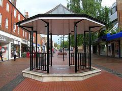
The town has two shopping centres, the Market Place and the Martlets as well as shops in Church Road, Church Walk, Cyprus Road, Junction Road, Keymer Road, London Road, Lower Church Road, Mill Road, and Station Road. There are several local commercial districts around the town, at Maple Drive, World's End, Weald Road and Sussex Way.
Historic buildings
Hammonds Place, to the west of London Road as it leaves the town to the south, is a handsome Elizabethan residence which was substantially re-built by the Michelbourne family in 1565, the date engraved on its porch. Part of a structure dating from about 1500 was retained with the house. Grove Farm House, just south of Station Road, can be dated to about 1600 and was built about the same time as Farthings in Keymer Road. Chapel Farm House and Walnut Tree Cottages on Fairplace Hill are on medieval sites and the present buildings date from the late Tudor period, as do Pollards Farm and Freckborough Manor House on the eastern boundary of the town.
High Chimneys in Keymer Road is a handsome farmhouse once called Woodwards, "Fowles Farm", a 17th Century dwelling is now called "Old Timbers" and West End Farm is now the "Woolpack Pub" were all built or, more correctly rebuilt in the 17th and early 18th centuries. The farm from which the town derives its name, referred to as Burgeshill Land in the 16th century, is now the site of Oakmeeds School and the Chanctonbury Estate. The farmhouse itself is long demolished.
Almost all the Victorian detached houses and workmen's terraced cottages built in the second half of the nineteenth century (when the town was renowned as a health resort) have survived.
Transport
Road: In 1770 the road from Cuckfield to Brighton across St John's Common was turnpiked. The A23 bypasses the town to the west, and joins up with the south end of the A273. The A273 follows the course of Jane Murray Way, directing traffic around the town centre and north on Isaac's Lane to Haywards Heath, or south through Hassocks on London Road. The A272 road runs north of Burgess Hill, from Winchester to near Uckfield. The B2112 runs east of Burgess Hill, going north–south, and both the B2036 and the B2113 pass through the town heading north–south and west-east respectively.
Railway: The opening of the London to Brighton railway in 1841 triggered a further expansion of the town, although Burgess Hill railway station was for many years a request stop and not a regular station. In 1877 the present station replaced the original one; some of the former buildings remain, however. Wivelsfield railway station serves the north end of Burgess Hill and was opened in 1886. Thameslink and Southern provide regular train services towards London and Brighton from both Burgess Hill stations. In addition, from Burgess Hill, one can travel on the branch of the West Coastway Line to Worthing, Littlehampton and Portsmouth, and from Wivelsfield, one can travel on a branch of the East Coastway Line towards Hastings.
Primary education
Secondary education
Burgess Hill is also served by Downlands Community School in nearby Hassocks and Warden Park School in Cuckfield.
Further education
Redevelopment
In 2004 Mid-Sussex District Council announced the Burgess Hill Master Plan, a scheme arranged with Thornfield Properties plc to massively redevelop Burgess Hill Town Centre. The Master Plan is part of a larger scheme which will also see the redevelopment of Haywards Heath and East Grinstead town centres.
The plan will result in the complete reconstruction of most of the town centre, and will also focus on the redevelopment of the Victorian era train station, which is seen by many as in need of updating. The implementation, which will take place over about half a century, also includes the construction of two hotels, the widening of a major artery road through the centre of the town, and the creation of a communal space as well as many new commercial opportunities.
The plan has been very controversial, primarily because it was planned to include the demolition of many residences and shops owned by the town's inhabitants. Some inhabitants were worried as to whether they would get a fair price for their property, and how local landmarks such as the independent Orion Cinema would be treated. Many were concerned what negative effects the redevelopment would have on their lives and the prosperity of the town as a whole. The Burgess Hill Master Plan was, and even after some major editing with consideration of the opinions of the townspeople of Burgess Hill and the surrounding villages, remains the most drastic out of all three Master Plans put across by the local council and Thornfield Properties plc. Early in 2010 Thornfield Properties was reported to be in financial difficulties.
Religion
There are several churches in Burgess Hill, including;
Burgess Hill is also home to the International Bible Training Institute which founded Mid-Sussex Christian Centre, formally Burgess Hill Pentecostal Church.
Providence Strict Baptist Chapel, one of many former Strict Baptist chapels in Sussex, closed in 1999 after 124 years of religious use. The Grade II-listed Neoclassical building was designed by Simeon Norman in 1875.
Recreation
Burgess Hill contains one nature reserve, Bedelands and on the east side of town is Ditchling Common Country Park, a 188-acre (0.76 km2) area of common land, set up in 1975. In the town centre the largest park is St. John's Park, with other smaller recreation grounds around the town. The Triangle leisure centre on the northern edge of the town is run by Freedom Leisure. Replacing the lido in St. Johns Park, the Triangle is also used for conferences. The Triangle was opened by Queen Elizabeth II in 1999.
Burgess Hill is one of the few towns to retain an independent cinema. The Orion Cinema, opened in 1928, has two screens and shows a mixture of mainstream and arthouse films. There is also a local theatre, which puts on productions quarter-yearly, the most popular of these being a pantomime, performed in the Martlets Hall. Musical theatre productions by Burgess Hill Musical Theatre Society (formerly Burgess Hill Operatic Society) are also held at the Martlets Hall.
The town is also home to the Mid Sussex Brass Band which has a second section contesting main band and a thriving youth band. As well as supporting local fetes and concerts, the band plays at concerts throughout the year in venues from Horsham to Hever Castle, and travels to Schmallenberg, Burgess Hill's German twin town, for the Schmallenberger Woche.
Burgess Hill has a Symphony Orchestra, which draws its members from Burgess Hill and the surrounding area. The Orchestra puts on two classical concerts each year, normally in May and November. Burgess Hill Choral Society perform two concerts every year, shortly before Christmas and in April or May.
Burgess Hill is also home to the UK's newest lasertag centre
Sport
Burgess Hill Town Football Club plays football in Isthmian Premier Division, the seventh tier of English football. The club plays its home games at Leylands Park.
Burgess Hill Rugby Football Club, or The Sussex All Blacks, are the local Rugby Football club, playing in Sussex RFU 1. Their home games are played at Poveys CLose. Burgess Hill also has a baseball team playing in the British AAA league.
Burgess Hill Cricket Club have four adult teams and a strong youth section. The First Team play in the county league, a strong and competitive league. The club plays at St. Johns Park.
Mid Sussex Hockey Club play their home games at The Triangle leisure centre, although their clubhouse is based in Haywards Heath.
Mid Sussex Youth Netball Club train at The Triangle and have many successful teams. The Triangle leisure centre was the home venue of Brighton Bears, a former basketball team. The franchise folded in 2006.
Several local pubs and social clubs enter teams into the Mid Sussex Pool League, although any venue with 10 miles (16 km) of "The Duck" in Haywards Heath can apply to join. The league plays World Eight Ball Rules.
There is also a squash club that plays at The Triangle every Saturday and Monday, and has a team that plays in the East Sussex County League.
There is also a running club that meet at the Burgess Hill School for Girls every Wednesday evening. Members compete in local and national charity and fun races.
The skate park in the centre of town provides sporting opportunities, and holds an annual competition.
The Triangle was one of the venues in the South East supporting the London 2012 Olympic Games, and served as a base and training centre for teams from around the world.
Town twinning
Burgess Hill's twin towns are:
A square in Schmallenberg has been named Burgess Hill Platz.
Notable people
In popular culture
I am a young executive. No cuffs than mine are cleaner;
I have a Slimline brief-case and I use the firm's Cortina.
In every roadside hostelry from here to Burgess Hill
The maîtres d'hôtel all know me well, and let me sign the bill.
From Executive in A Nip in the Air (1974).