
Area 5.2 km (2.0 sq mi) OS grid reference TQ351151 District Lewes | Population 158 (Parish-2011) Civil parish Streat Shire county East Sussex | |
 | ||
Streat is a village and civil parish in the Lewes District of East Sussex, England. The village is located 3 miles (4.8 km) south east of Burgess Hill and 5 miles (8.0 km) west of Lewes, longer by road, centred on remnant foothills just north of the South Downs National Park and reaching up to the South Downs.
Contents
The 11th-century parish church has no dedication; the ecclesiastical parish is joined with Westmeston.
Etymology
Anglo-Saxon place names containing "Street", "Streat" or "Stret" usually indicate a Roman road, and this is the case here, as Streat is built on the Sussex Greensand Way, and there is a north-south Roman or Romanised Celtic road known as the Middleton Track just over the west parish boundary border at Hayleigh Farm sweeping past Grade II listed Middleton Manor which ascends the South Downs escarpment passing above the Victoria Jubilee Middleton Plantation.
Landmark - Foothills
Clayton to Offham Escarpment is a Site of Special Scientific Interest, which stretches from Hassocks in the west and passes through many parishes including Streat, to Lewes in the east. The site is of biological importance due to its rare chalk grassland habitat along with its woodland and scrub.
Old Rectory
There is an Old Rectory, a listed building, which may indicate the existence of chancel repair liability to any lay improprietors of land which was once belonged to the church.
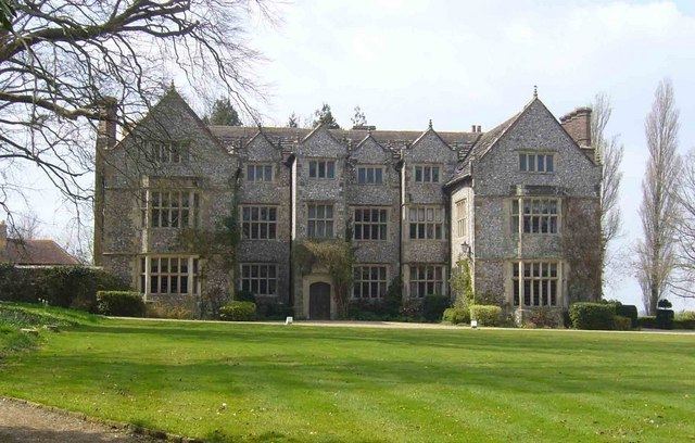
Streat Place
Streat Place is a manor house built in the early 17th century by Walter Dobell who died in 1624. The building has an E shaped plan with central porch and projecting wings. Its national listing gives it as Grade II* and reveals its architectural merit as including its entire facing of knapped flints with long and short ashlar quoins to each window bay.
Streat Hill
The long north-south parish reaches its highest point in its southern quarter, here Streat Hill rises to 224m above sea level; here there are two earthworks or tumuli. These are two bowl barrows which are termed by archaeologists the Western Brow round barrow cemetery.