
Population 10,260 (2011 census) Elevation 5 m (16 ft) Local time Friday 9:12 PM | Postcode(s) 4805 Postal code 4805 | |
 | ||
Location 1,159 km (720 mi) NW of Brisbane189 km (117 mi) NW of Mackay201 km (125 mi) SE of Townsville Weather 27°C, Wind SE at 13 km/h, 82% Humidity Points of interest Big Mango, Peter Faust Dam, Bowen Jetty | ||
Bowen queensland
Bowen is a town and locality in the Whitsunday Region on the eastern coast of Queensland, Australia. At the 2011 census, Bowen had a population of 10,260.
Contents
- Bowen queensland
- Map of Bowen QLD 4805 Australia
- Geography
- Economy
- Government
- Discovery by Europeans
- Establishment of the town
- Shipwrecks
- Schools
- World War 2
- Climate
- Television
- Heritage listings
- Tourism
- Australia
- Entertainment
- Education
- Notable residents
- Sister cities
- References
Map of Bowen QLD 4805, Australia
Geography
Bowen is located on the north-east coast, in North Queensland, Australia, at exactly twenty degrees south of the equator. The twentieth parallel crosses the main street. Bowen is halfway between Townsville and Mackay, and 1,130 kilometres (700 mi) by road from Brisbane.
Bowen sits on a square peninsula, with the Coral Sea to the north, east, and south. To the south-east is Port Denison. On the western side, where the peninsula connects with the mainland, the Don River's alluvial plain provides fertile soil that supports a prosperous farming industry.
Economy
The town enjoys a diversified and prosperous economy based on agriculture, fishing, tourism, and mining. Its unusually dry climate for a tropical location, plus its fertile alluvial soil, makes it the ideal place to grow a wide variety of small crops, including tomatoes, rockmelons (i.e., cantaloupes), and capsicums (i.e., green peppers). Outside the alluvial plain, much of the Bowen area is used for beef cattle.
Just north of Bowen is the Abbot Point coal loading port. Coal mined inland of Bowen in Collinsville and other towns in the Bowen Basin is brought by rail to a deepwater pier to be loaded on bulk carriers. Coal is exported mainly to China and India.
Government
In 1944 Bowen elected a Communist, Fred Paterson, to Queensland Legislative Assembly. He was re-elected in 1947, but lost the seat in 1950 when the boundaries were changed to include Bowen in the seat of Whitsunday.
Bowen was the administrative centre for the Shire of Bowen. On 15 March 2008, under the Local Government (Reform Implementation) Act 2007 passed by the Parliament of Queensland on 10 August 2007, the Shire of Bowen merged with the Shire of Whitsunday to form the Whitsunday Region. Although Proserpine is the administrative centre for the new regional council, the council maintains offices in Bowen and holds a number of council meetings in Bowen each year.
Discovery by Europeans
Captain James Cook named Cape Gloucester on his voyage of exploration up the Australian coast in 1770. This "cape" turned out to be an island, and Gloucester Island dominates the view from Bowen's eastern beaches. Behind the island is a bay that forms an excellent port, which the town came to be built around. This bay was eventually discovered in 1859 by Captain Henry Daniel Sinclair, in response to a reward offered by the colony of New South Wales for finding a port somewhere north of Rockhampton. Sinclair named Port Denison after the colonial governor of New South Wales, William Denison.
Establishment of the town
Two years later, Sinclair led one group of settlers by sea, and George Elphinstone Dalrymple led another party overland from Rockhampton. They met on 11 April 1861 at Port Denison and founded the town of Bowen on the next day, 13 April 1861. By this time, Queensland had separated from New South Wales, and the town was named after the first Queensland colonial governor, Sir George Bowen.
Port Denison Post Office opened on 1 April 1861 and was renamed Bowen by 1865.
Shipwrecks
In 1863, the new settlers discovered a sailor, James Morril, who had been shipwrecked 17 years previously just to the north of Bowen. Morril made his home in the new town, and his grave is still to be seen in the Bowen cemetery.
The coral reefs around Bowen have several shipwrecks, including the SS Gothenburg which sank in 1875 with a loss of more than 100 lives. Numerous relics of Bowen's history, from the Aboriginal past onwards, are on display at the Bowen Historical Society's museum.
Schools
Bowen State School opened in 1865. Between 1877 and 1922, it operated as two schools: Bowen Boys State School and Bowen Girls and Infants State School. A secondary department was added to Bowen State School in 1928. On 23 January 1961, the secondary department was replaced by Bowen State High School.
St Mary's School was opened on 1 September 1872. Merinda Provisional School opened in 1898 and became Merinda State School on 1 Jan 1909. Queens Beach State School opened on 25 November 1940.
World War 2
During World War 2 Bowen hosted an air force base, flying PBY Catalina flying boats to search for enemy ships and submarines. The concrete aprons and ramp are still present (2013), and silhouettes of two aircraft have been painted in.
Climate
The town is located in the dry tropics. It is noticeably drier than surrounding locations due to a rain shadow effect produced by the nearby Gloucester Island. Due to the town's latitude, the trade winds provide a pleasant breeze. The warmest month is January, with an average maximum temperature of 31 °C (88 °F). The coolest month is July, with an average maximum temperature of 25 °C (77 °F) and an average overnight minimum of 13 °C (57 °F).
Television
Bowen is serviced by Six free to air channels. Bowen picks up regional affiliates and can possibly pick up Brisbane channels. The Brisbane channels are:
The regional affiliates are:
Foxtel is also available in the Bowen area
Heritage listings
Bowen has a number of heritage-listed sites, including:
Tourism
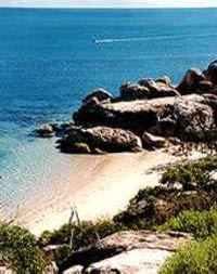
Bowen is on a peninsula, with ocean on three sides. This gives eight beaches surrounding the town, namely Kings Beach, Queens Beach, Horseshoe Bay, Murrays Bay, Greys Bay, Rose Bay, and the Front Beach. There is also the clothing-optional Coral Bay. Kings Beach offers views of nearby Gloucester Island. On the western half of Queens Beach and all of Kings Beach, it is permitted to walk a dog without a leash.
The Big Mango, costing $90,000 to create, was erected in 2002 as a tourist attraction at the Bowen Tourist Information Centre. In February 2014, the 10-metre high, seven-tonne fibreglass structure was stolen in an overnight operation. The mango was found the next day and it was later revealed that the theft had been a publicity stunt.
Australia
In December 2006, it was announced that Bowen was chosen as a filming location for a third of the production of Australia, directed by Baz Luhrmann and starring Nicole Kidman and Hugh Jackman, portraying the look of Darwin. Bowen was chosen as a prospect due to the financing of $500,000 by the Queensland government. The production moved to Bowen on 14 May 2007.
When it was announced that Australia was to be filmed in Bowen, locals painted a large "Bowenwood" sign on an old water tank on top of a hill, in a parody of the world-famous Hollywood sign.
Entertainment
Bowen boasts a cinema, the Summergarden Twin Theatre, the Denison Hotel, the Queens Beach Hotel, the Central Hotel, the North Australian Hotel, the Commercial Hotel, Barnacles Backpackers and the Grand View Hotel. It also offers four motels and seven caravan parks. There is also a golf course that overlooks Queens Beach.
Education
Bowen State School is a government co-educational primary school (P-6) at 29 Kennedy Street. In 2015, it had an enrolment of 480 students with 34 teachers (30 full-time equivalent).
Queens Beach State School is a government co-educational primary school (P-6) at 39 Tracey Street. In 2014 (when it was a P-7 school), it had an enrolment of 452 students with 32 teachers (30 full-time equivalent).
Merinda State School is a government co-educational primary school (P-6) at Bergl Street. In 2015, it had an enrolment of 87 students with 7 teachers (5 full-time equivalent).
St Mary's Catholic School is a Roman Catholic co-educational primary school (P-6) at 39 Poole Street. In 2015, it had an enrolment of 83 students.
Bowen State High School is a government co-education secondary school (7-12) at 1-9 Argyle Park Road. In 2015, it had an enrolment of 657 students with 58 teachers (56 full-time equivalent).
TAFE Queensland North is a government co-educational tertiary institute for vocational skills. Its Bowen campus is at 98-158 Queens Road. Before 2013, the Bowen campus was part of the Barrier Reef Institute of TAFE.