
- location below Mount Roundhill Basin area 1,200 km² Basin area 1,200 km² | - elevation 253 m (830 ft) - elevation 50 m (164 ft) Length 60 km | |
 | ||
- right Wild Creek, Oaky Creek (Queensland), Spring Creek (Queensland), Simon Creek (Queensland), Ida Creek, Menilden Creek, Grasstree Creek, Police Camp Creek | ||
The Don River is a river located in North Queensland, Australia.
Contents
Map of Don River, Queensland, Australia
Course and features
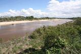
The Don River rises in the Clarke Range, part of the Great Dividing Range, below Mount Roundhill and west of Proserpine. The river flows generally north by northeast through the Eungella National Park and is joined by thirteen minor tributaries, towards its mouth and empties into the Coral Sea north of Bowen. With a catchment area of 1,200 square kilometres (460 sq mi), the river descends 253 metres (830 ft) over its 60-kilometre (37 mi) course.
High salinity levels have been recorded at the mouth of the river. Land use in the upper catchment is mostly beef cattle production with crops grown in the richer soils downstream.
The river is crossed by the Bruce Highway via the Don River Bridge at Bowen.
Flooding
The highest recorded flood was in 1970 when the river reached 7.25 metres (23.8 ft) at the Bowen Pumping Station. The river delta is particularly vulnerable to flooding during cyclones.
Floods in 2008 left deposits of sand which raised the riverbed considerably. Approval to dredge sand was granted by the Queensland Government however only about half of that has been removed in recent years. A flood in 2008 lead the Whitsunday Regional Council to create a channel so that similar flooding could be avoided.
A management plan for the river was established late in 2008. It included measures to encourage further sand extraction.