
Country India Area 43 km2 Region Bayaluseeme Literacy • Average87.65% | ||
 | ||
Colleges and Universities Guru Nanak Dev Engineering College - Bidar, Karnataka Veterinary - Animal and Fisheries Sciences University, Veterinary College - Bangalore | ||
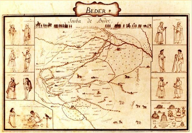
Map of Bidar
Bidar is a hill top city in the north-eastern part of Karnataka state in south India. It is the headquarters of the Bidar District which borders Maharashtra and Telangana. It is a rapidly urbanising city in the wider Bidar Metropolitan area. The city is well known for its many sites of architectural, historical and religious importance.
Contents
- Map of Bidar
- Bidar historical places
- Experience bidar through this award winning documentary
- Toponymy
- History
- Geography
- Geology
- Soil
- Climate
- Economy
- Tourism
- Mahmud Gawan Madrasa
- Gurudwara Nanak Jhira Sahib
- Bidri wares
- Rail
- Air
- Education Institutions
- Introduction
- Surang Bhawis of Bidar
- Jamna Mori
- References
Being located at the farthest of around 700 km (430 mi) from the state capital Bengaluru, it has been neglected by the state government for a long time. However, owing to its rich heritage, the city has a prominent place on the Archaeological Map of India. Picturesquely perched on the Deccan plateau, the Bidar fort is more than 500 years old and still standing strong. According to the book "Bidar Heritage" published by the state Department of Archaeology, Museums and Heritage, of the 61 monuments listed by the department, about 30 are tombs located in and around Bidar city., explaining its nickname, "City of Whispering Monuments". The heritage sites in and around Bidar have become the major attraction for film shooting in recent years with Bollywood making visits apart from kannada film industry
Bidar is home for the second biggest Indian Air Force training centre in the country. The IAF Station Bidar is used for advanced jet training of prospective fighter pilots on BAe Hawk aircraft.
Bidar city is known for its Bidri handicraft products, and its rich history. Bidar is also considered one of the holiest place for Sikh pilgrimage. Unlike other places in the region, Bidar is the coldest and wettest place in north Karnataka. For the year 2009-10, Bidar was ranked 22nd among the cleanest cities in India, and 5th cleanest in Karnataka. SH4 passes through Bidar and the whole city is integrated with 4 lane road.
Ancient Karez System in the city have been recently discovered. The Karez (Qanat) is an underground network of aqueducts for water supply. The Bidar Karez, built in the 15th century, is more than 3 km (1.9 mi) long with 21 air vents. Underground canals, built to connect underground water streams, were meant to provide drinking water to civilian settlements and the garrison inside the Bidar fort. This was necessary in a city where the soil was rocky and drilling wells was difficult.
Bidar historical places
Experience bidar through this award winning documentary
Toponymy
Bidar is believed to have got its name from Bidri works, .
Legend has associated Bidar with the ancient kingdom of Vidarbha, to which references are found in early Hindu literature like Malavikagnimitra, Mahabharata, the Harivamsa, Bhagavata, and a few other Puranas. Its association can be seen apparently on account of the similarity in names Bidar and Vidarbha. This has been mentioned in Firishta's writings.
The traditional tales reveal that Vidura lived here; hence the place was earlier called Viduranagara and also as the place where Nala and Damayanti (Daughter of Raja Bhima, the King of Vidharba) were meeting.
History
The recorded History of the city goes back to third century B.C. when it was of the great Mauryan Empire. After the Mauryas, Satavahanas, Kadambas and Chalukyas of Badami and later Rashtrakutas reigned over Bidar territory. Chalukyas of Kalyana and Kalachuris of Kalyanis also regained the area. For a short period after Kalyani Chalukyas the area of Bidar was under the sevunas of Devgiri and Kakatiyas of Warangal.
Delhi rulers first headed by Allauddin Khilji and later Muhammed-bin-Tughluq took control of entire Deccan including Bidar. About the middle of the 14th century the Sultan's officers stationed in Deccan rebelled and this resulted in the establishment of Bahamani Dynasty in 1347 A.D. at Gulbarga (present Kalaburagi). There were frequent warfare between the Bahamnis and Vijaynagar Kingdom.
The history of the present fort at Bidar is attributed to the Sultan Ala-ud-Din Bahman Shah the first sultan of the Bahmani dynasty to 1427 when he shifted his capital from Gulbarga to Bidar since it had better climatic conditions and was also a fertile and fruit bearing land. Earliest recorded history of its existence as a small and strong fort is also traced to Prince Ulugh Khan in 1322, whereafter it came under the reign of the Tughlaq dynasty.
With the establishment of the Bahmani dynasty (1347), Bidar was occupied by Sultan Ala-Ud-Din Bahman Shah Bahmani. During the rule of Ahmad Shah I (1422–1486), Bidar was made the capital city of Bahmani Kingdom. The old Fort was rebuilt and beautiful madrasas, mosques, palaces and gardens were raised. Mahmud Gawan who became the Prime Minister in 1466 was a notable figure in the history of Bidar. Bidar remained under the Barid Shahi dynasty until conquest by Bijapur Sultanate in 1619. Aurangzeb came to Bidar after his father, Padshah (emperor) Shah Jahan, appointed him the Prince of Deccan. He wrested the Bidar Fort from the Adil Shahis after a 21-day war in 1656. With this, Bidar became a part of the Mughal dynasty for the second time. Bidar was made a subah (imperial top-level province) in 1656, which Telangana Subah was merged into the next year.
In 1724, Bidar became a part of the Asaf Jahi Kingdom of the Nizams. It was annexed by the Bijapur Sultanate in 1619–20 but the Mughal viceroy of Aurangzeb took it in 1657 and thus became a part the Mughal Empire in 1686. Third son of Asaf jah l ( Nizam l ) Mir Sa'id Muhammad Khan, Salabat Jang ruled from Bidar fort from 1751 to 1762, till his brother Mir Nizam Ali Khan Asaf Jah III imprisoned him in this fort, and was killed in Bidar fort on 16 September 1763. Mohammedabad old name of Bidar is also on his name.
Thus, Bahmanis ruled over Gulbaraga from 1347 to 1424 and from Bidar from 1424 till the extinction of the kingdom and its disintegration into five independent kingdoms of Bijapur, Golconda, Ahmadnagar, Bidar and Berar. After India's independence, in 1956 when Bidar became part of Mysore (now Karnataka) state.
Geography
Bidar is located at 17.9°N 77.5°E / 17.9; 77.5, lies at a central position in Deccan, a plateau at an elevation of 2300 ft from the sea level. It has common boundaries with Maharashtra and Telangana which is, with the districts of Nizamabad and Medak in Telangana on the East and the districts of Nanded and Osmanabad in Maharashtra on the west. On the south lies the district Gulbarga of Karnataka.
Geology
The upper crust of the plateau is of laterite, a soft porous rock with limonitic surface. This crust varies in depth from 100 ft (30 m) to 500 ft (150 m) and rests on a bed of trap, which is of much harder texture and less pervious to water. The volume of water filtered during the monsoons through the laterite stratum is arrested by the trappean bed, and a nursery of springs is formed whose natural level of effluence is the line of contact of the two strata along the base of the cliffs of the plateau. The water in course of time frets out for itself an orifice and macerates and loosens portions of its rocky channel till a rift is produced. The rift gradually dilates into a ravine, and the ravine expands into a vale.
The Karez System is built along a geological fracture. Such fractures are formed at the intersection of laterite and basalt rocks and form lineaments or springs that yield water.
Soil
Bidar soils are deep (>100 cm), well-drained gravelly red clayey soils developed on plateaus of laterites. They are slightly acid to neutral (pH 6.6) in reaction with low cation exchange capacity. They are highly gravelly soils with gravel content (60 to 10%) that decrease with depth.
Climate
The winter season is from November to middle of February. Bidar is one of the coldest cities (by southern standards) in Karnataka as the minimum temperature during winter nights regularly hovers around 11-12 during December, which is the coldest month with mean daily maximum temperature of 27.3 C and mean daily minimum of 13.4 C. From the middle of the February, both day and night temperatures begin to rise rapidly. May is the hottest month with mean daily maximum temperature of 38.8 C and mean daily minimum of 25.9 C. With the withdrawal of southwest monsoon in the first week of October, there is slight increase in day temperature but night temperature decreases steadily. After October, both day and night temperatures decreases progressively. The highest maximum temperature recorded at Bidar was on 8-5-1931(43.3 degree C) and the lowest minimum was on 5-1-1901(2.9 degree C, the lowest temperature ever recorded in Karnataka).
Present day Bidar covers an expanse of 5448 square kilometres of land and lies between 17°35′ and 18°25′ North latitudes and 76°42′ and 77°39′ east longitudes. Maharashtra on the west. On the south lies the district of Gulbarga of Karnataka. This central position in the Deccan had for long imparted to Bidar, the pre-eminent position in the history of the Deccan although today it presents a picture of centuries of neglect and ruin. It was also known as Mohamad-Bidar and under the influence of Hindus it became as Bidar.
Economy
Once a home to many cottage industries, such as cotton and oil-ginning mills, there are now few industries that draw on local raw materials or skills. Even the well known form of local articrafts, bidri ware, is in a state of decline. Increasing prices of materials, especially silver, and declining sales have meant that many of the hereditary artisans are no longer employed in the production of such ware.
Tourism
Bidar is symbolically described as City of Whispering Monuments. The mountaintop city that served as the capital of medieval Deccan, has 98 monuments of which four national monuments are protected by the Archaelogical Survey of India and 14 by the State Archaeology Department, Karnataka.
Bidar earned a place on the World Monument Watchlist 2014. Of the 741 proposals received from 166 countries, 67 sites from 41 countries were finally selected which were announced by WMF president Bonnie Burnham in New York on October 8, 2013. Along with "the historic city of Bidar", two other sites in India to figure in the list were the house of Sheikh Salim Chisti in Fatehpur Sikri and Juna Mahal in Rajasthan.
The WMF in its current watch site for "the historic city of Bidar" says ″challenges to the site include a lack of integrated conservation and maintenance, environmental pollution, and the construction of new developments and roadways that encroach on the historic fabric. Current land use regulations also threaten the economic livelihood of many of the city's residents, and it is hoped that revised, context-specific planning policies would both protect Bidar's historic assets while also supporting the future of its local population. It is hoped that Watch-listing will spur documentation and analysis of the city's conditions, followed by policy development and applied conservation interventions that will reveal and maintain Bidar's rich heritage, as well as support a robust and sustainable tourist industry.″
Mahmud Gawan Madrasa
This grandiose madrasa was built by the prime-minister of the Bahmani empire, Mahmud Gawan in the late 15th century. Its only the most imposing building of the Bahmani period, but in its plan and in the general style of its architecture it is a unique monument of its kind in India. The Madrasa, a multi-disciplinary university he set up, which had a library of around 3,000 valuable manuscripts, was severely damaged when gunpowder stored inside the rooms went off during a 27-day siege of the city by Mughal king Aurangazeb in 1656. The Mahmud Gawan Madrasa is protected by the Archaelogical Survey of India.
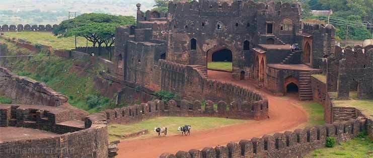
Bidar Fort is considered one of the most formidable forts of the country. Bidar city was distinctly planned and built. The main citadel complex housed the royal places. Mahals and Mosque. Adjoining to this on the southern side, the city was built for the people. Both the citadel complex and city had separate forts for protection the plan of the Bidar city fortification is pentagonal. There are five gateways for entry into the city fort. It is main citadel complex fort which is stronger. It is built on the brink of the plateau. Engineers and architecture of various countries were employed on its design and construction. A Museum is preset there having old armor, old sculptures. including many of the ancient stones,
The design of this monument represents the blend of the both Hindu and Muslim architecture. There are rooms in the basement of the Rangin Mahal.
The building had stately dimensions and exquisite surface decoration. The coronations of several Bahamanis and Barid Shahi sultans were held there. From the royal pavilion which is situated behind throne palace one can view the valley and low land below.
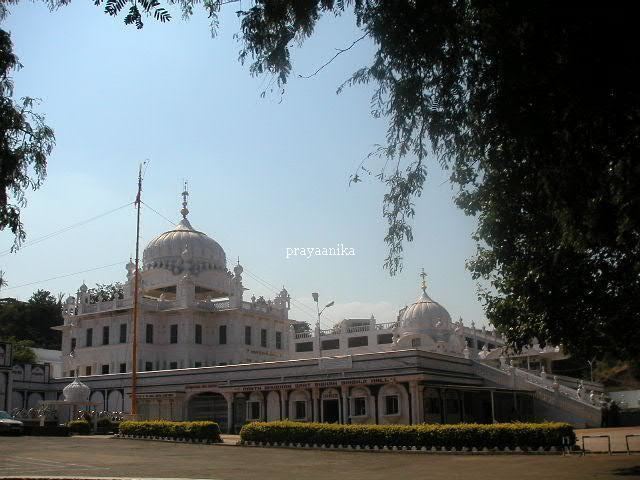
Gurudwara Nanak Jhira Sahib
Gurudwara Nanak Jhira Saheb is known to be one of Holiest Place For Sikh Devotees in India and is believed that Saint Guru Nanak visited the place during famine in this region. Papa Nashini Mandir Dargah Hazrat Shah Shamsuddin Quadri (Multani Basha) Dargah Hazrat Syed Abul Faiz Mailar Mallana Mandir Narasimha Jharni Mandir Changleri Veerabhadra Mandir
Bidri wares
Bidriware, one of the rarest and most intricate art forms is now unique to the city. This native art form has obtained Geographical Indications (GI) registry. The various art forms created by artists from Bidar city centuries ago are now major attractions in museums such as Victoria and Albert Museum, London, the National Museum in New Delhi and Indian Museum in Kolkata.
The Karnataka tableau at the 2011 Republic Day Parade at Rajpath in New Delhi featured Bidriware and Bidri artisans from Bidar.
All the dignitaries & guests of XIX Commonwealth Games 2010 were presented with mementos hand crafted in Bidri art. This art form is the Union government's choice for souvenirs at the World Economic Forum in Davos. The Kingfisher company owner Vijay Mallya has a bidri dining table with floral designs made of nearly 3.5 kg silver.
Gulbarga-based artist and scholar Dr Rehaman Patel has done extensive research on Bidriware entitled "Bidri Art of Karnataka" submitted to Gulbarga University and was awarded in 2010. Later the book on same is published by Indian Royal Academy of Art and Culture financed by the Dept. of Kannada and Culture in 2012. He did reserch on 'International Bidri Collections' under the fellowship program sanctioned by Karnatak Shilpakala Academy. Bangalore for the year 2014-15. Dr. Patel has published several articles in news papers and journals on Bidri Art which can be search on internet.
Rail
Bidar has connectivity with Bangalore, Hyderabad, Sainagar Shirdi, Parbhani Jn, Aurangabad, Latur, Nanded, Manmad, Mumbai and Renigunta (according to railway budget 2014-15) Construction of the Gulbarga-Bidar link is in progress which is expected to be operational by the end of 2015. Bidar-Hyderabad inter-city train service became operative in September 2012. A Bidar-Yeshwantpur (Daily) express train and Bidar-LTT Mumbai express train service has been started recently. another train starting from bidar through Latur to Mumbai started, which runs on Thursday,Saturday and Sunday the train which stars from auranagav
Air
The city is home to an air force station. There is no civilian airfield; however, The Hindu reported in February 2017 that the opening of the air force base to passenger flights was likely under the central government's Ude Desh ka Aam Naagrik plan.
Education Institutions
Introduction
Karez (Qanat) is one such method of collection, transportation, storage and distribution of ground water developed in drier parts of the world. Qanat is a common term used in Persian region, considered to be the place of origin of this technology. Qanat is an Arabic term most commonly used meaning ‘lance’ or ‘conduit’. The original Persian term is ‘Kariz’ or ‘Karez’. The diffusion of Qanat system from Persia to the rest of the world has yielded many names. For example, in North Africa it's called fugara (pronounced as foggara), falaj in Arabia, ‘qanat romani’ in Jordan and Syria, galerias in Spain, ‘ketthara’ in Morocco, ‘kanjering’ in China and ‘Kariz’ in Afghanistan and Pakistan (Qanat in its Cradle, ICQHS 2012). In India, they are known as Karez or locally called Surang-Bhawi's (V Govindan kutty, 2013)
It is believed that the technology originated in North West Iran though contested but has not been negated till now. The precisely there are no written records to suggest when was the first qanat dug. Henry Goblot in his book entitled "Qanats; A Technique for obtaining water" argues it was probably during first millennium before Christ the first qanats were dug. He mentions how the tribes settled in Iranian plateau used the Akkadian copper miners to extend the tunnels they had dug for draining out water from the mines. These tunnels were extended up to the villages and continued as surface channels for irrigation. (Qanat in its Cradle, ICQHS 2012). This was probably the origin point of subterranean aqueduct for potable water and irrigation. Later on carried forward by many clans, dynasties etc. who followed, including the Romans.
Surang Bhawi as its known in Karnataka is one the traditional methods of harvesting groundwater in most sustainable way. Across the world it has given birth to thousands of settlements over the past 2500 years and helped to sustain many more. The ingenious technology of Surang Bhawi was result of need for harnessing groundwater in arid and semi arid areas like that of Bidar or Bijapur. This traditional technology has to be viewed in historical perspective linked to sustainable utilisation and management of groundwater and above all conserving the environment.
The Surang Bhawi system is one of the best available demonstration of human ingenuity and adaptability to situations and locations of water scarcity. The Surang Bhawi systems and associated landscape in Bidar is one of the few that could be found in India. The prominence of Surang Bhawi systems increases as its active to a certain extent even today, though there has been a negative impact of urban development on it.
The Surang Bhawi systems is a demonstration of the traditional sustainable practices followed for water management during historic times, a time when remote sensing technology or sophisticated equipment was not at disposal for water divining and tunnelling with precision.
In India, Surang Bhawi's can be located at Bidar, Bijapur, Aurangabad, Hukkeri, Burhanpur, Pune, Warangal and in most probably it exists in Gulbarga (needs to be authenticated) as well.
The Surangams or Thurangams in Southern Karnataka and Northern Kerala are totally different from that of a karez system in many aspects ( Sudeer Tripathi). Though they look similar they are of much recent origin but possibility of Persian influence is not ruled out.
Surang Bhawi's of Bidar
It is considered that during the Bahmani period four Surang-Bhawi systems were created. Evidences obtained do suggest in this direction. The first one, called "Jamna Mori" part of it stretches between Fateh Darwaza and the triple moat of Royal enclosure. This system was created to provide potable water to the general public and royal enclosure. This is probably the first ever Surang Bhawi constructed in India. The second one called Shukla theerth was probably created to fill the moat of royal enclosure and irrigation. Preliminary investigations done by Valliyil Govindankutty and team YUVAA reveal these two systems were probably interlinked. Both these Surang- Bhawi systems provided water to the residents even during an enemy siege. These two systems were probably constructed during the phase of initial settlement development within the public and royal enclosures.
The third Surang Bhawi system known today as Naubad Karez System was part of a scheme for developing a new settlement at Naubad. Aliabad Spring the primary source of water to Aliabad village was further exploited to increase yield by developing it as a Surang Bhawi System. Investigation on this system revealed
The fourth was constructed at Kamthana village about 6 km from Bidar. It starts from the historic Kamthana Bhandara (reservoir) with a huge laterite stone embankment build across the valley fill between Kamthana and Bidar neighbourhood. The subterranean aqueduct here takes water from the kamthana reservoir to another smaller lined tank little downstream for further distribution to fortified village. This is not an infiltration surang bhawi which collects groundwater from aquifer and transports, but rather a subterranean lined channel build for transporting water for long distances between reservoir and kamthana village.
Constructions of water systems have been one the primary and key initiative of any rulers in Deccan, being a drought prone area. Hence, as their normal practice they wanted to equip with adequate water supply before initiating the development of settlement.
Jamna Mori
Probably the first ever constructed Surang Bhawi System in India. Shri. Gulam Yazdani was the first to document the system. The map prepared by him shows Jamna mori stretches between Fateh darwaza and Tripple moat of royal enclosure. But the physical investigation carried out reflects it might extend beyond Fateh darwaza towards water rich area south and south west of the city. This system might be the longest one in Bidar. Shri. Gulam Yazdani defines the vents in the documented section as small manholes with diameter less than a meter. His map showcases sixteen manholes between Fateh darwaza and triple moat. Investigations also reveal that the system does not end here; it probably extends below the moat and enters the royal enclosure and opens up in the ravine valley inside to flow as surface channel. The surface channel leads to the Bomakondeswara lake ( ) inside royal enclosure. The lake once reaches the highest level drains into the triple moat through a tunnel system ingeniously created for it.
This system probably ensured that the lake remains perennial. The royal enclosure might have been a self-sustaining one.
Inside the public enclosure the systems runs through or near some the important structures of then times or have been connected with underground channels for easy access to good potable water. Some the prominent structures being Jami Masjid, Mahboob Ganj and Usman Ganj market place, and Mahmood Gawan Madrasa. Mahamood Gawan Madrasa also had its own way of collecting rainwater as well. Probably, first of the rainwater harvesting mechanisms in Bidar. Network of pipelines could be seen running through the walls bringing water from roof top to the well in the court yard.
Above this the preliminary investigations did also point at probable existence of several sub channels connecting the main aqueduct within the public enclosure. The researcher also believes there is possible connection between Jamna Mori and Shukla Theerth Systems. These are being explored by researcher.
As off now it's very difficult to identify the vents of this system with unplanned urban growth engulfing every inch of space. Conserving of such underground water system in laterite terrain becomes very important. Single point pollution itself can prove to be critical in this highly porous rock by polluting the entire aquifer. Hence community level initiative is required to conserve this system.
Shukla Theerth
This system runs right outside the fort enclosures, with one of the air vents located inside the fire force compound of present-day Bidar. The origin and end both are not clearly know. More physical investigation is required. This again runs through one the most unplanned areas of Bidar, with settlements having encroached every single inch of space. Few of the possible vents investigated were found to be connected with toilet exists, thus polluting ground water directly. Lack of knowledge on these historic systems has led to its destruction by pollution and encroachments.
Shukla Theerth probably has a length of approx 4 km or more leading towards Gornali Kere. It may have branches as well on extending towards Chidri.
One of the air vents can be located at Bidar Fire Station. More air vents can be located in neighbouring graveyard and further towards Ambedkar circle. Most of these vents have been mapped and further investigations are in progress.
The system probably exits out somewhere along the plateau edge. It runs under the settlements on the lower side of Bidar Fire Station. Few vents have been located here as well. The water from this was used to supply water to Agrahar Settlement through terracotta pipes. For this well lined tank of approx 20 m2 could be located towards the agriculture fields and water slides carved on basalt stone could also be located even now.
The land use change made in this area has done damage to the channels and subterranean network. The channels lead to the moat of Bidar fort.
Naubad Surang Bhawi
"Naubad" is located 4 km north west of Bidar fort city towards Udgir. This is an area serviced by the City Municipal Council of Bidar. Naubad is mostly a residential and institutional area. It's here that the third surang bhawi system or karez system of Bidar is located. During the Bahmani period there was probably a scheme for developing a village at Naubad. As their normal practice they wanted to equip Naubad with adequate water supply before initiating the development of settlement. The ruling class may have employed Persian engineers or local water diviners for exploring water resources. The Aliabad Spring (near present Siddheshwar temple) was the site chosen for construction of surang bhawi.
The areas having hard laterite on the surface and basaltic Deccan trap below form ideal conditions for developing the surang bhawi System. The water diviners may have mapped the area well and decided to construct along the fracture line. This might have been done during summer when the water table is low. Traditional methods of water diving with help of biological indicators and sixth sense of water diviners are part of normal custom in these parts. Once mother well is established a surface survey was done to establish the distance of each vent and direction of karez gallery. In line with the mother well several wells at near about equal distance might have been dug to further establish the water table.
The construction of Surang Bhawi was laboriously done on the laterite plateau. The hard laterite provided ideal conditions for cutting through vertically and horizontally. For removing debris, air circulation and light at approximately every 50 meters, vertical shafts were constructed. The vertical shafts are 15 to 17 metres (before restoration was initiated) deep on an average.
The recordings made by Gulam Yazdani indicated the existence of 21 vertical shafts or air vents. But there are about 27 visible vertical shafts or air vents inclusive of branch gallery. A number of vertical shafts have been closed for one or other reasons. The some of the air vents are provided with masonry lining (historically without any mortar) and 2 ft high parapet (parapet is mostly modern entity). The average dimension of the air vent is 4 m2. Lack of maintenance, thick vegetation growth, and run-off erosion has led to collapse of parapets.
As described by Yazdani, "The Karez at Naubad was probably given up owing to death of king or due to some other causes". This is evident in their present state. Probably, if the Naubad settlement had come up, the karez would have been well maintained and traditional knowledge prevailed to this day.
Naubad Surang Bhawi has a total length of 2.56 km from Karez Mouth to Mother Well including the branching. The well at Nirmithi Kendra complex forms the junction well. The branch is approx 800 meters in length. Further in all probability it branches into two stretching along the Naubad Embankment. This mud embankment is historic, probably built before the Bahmani rule. Naubad Bhandara (reservoir) created by this embankment is the groundwater recharging tank collecting all the runoff from surrounding slopes. The infiltering water from tank keeps feeding the surang bhawi gallery with perennial flow of water. Thus, this Surang Bhawi system can be called as "qanat-e Saddi" (based on classification presented by .....).
The average depth of Surang Bhawi gallery from surface is 20 meters and air vents located approximately 50 meters interval. The distance mentioned here are surface measurements connecting aerial distance between vents, the gallery length may vary as it zigzags through the geology.
The entire gallery is still not being accessible and has hindered the measurement of gallery. Above this a basalt stone lined adit of 90m length runs from the mouth to a collection tank. The average depth of adit is 4.5 ft.
The water further flows down as streams to a natural collection spot about 2–3 km from the mouth. Many smaller streams join and further moves on ahead to join the river.
It is also believed that there is a terracotta pipe line running from surang bhawi to "Shikar- Gah" (re-discovered by V Govindan kutty and team during surveys).
A detailed study was carried out by geographer and researcher V Govindan Kutty during 2012–2013 and he has published the work in the form of the report "Conservation of Naubad Karez System and Cultural Landscape" which was submitted to Government of Karnataka and further actions reports were submitted through 2013 and 2014 which was even vetted by Sr. Archaeologist and during May 2015 rejuvenation work of karez was initiated under the leadership of Kunjambu ettan from Kasaragod Kerala, a water diviner and surangam practitioner, moreover a water warrior. Today the Naubad Surang Bhawi is accessible up to vent 9 without any hindrance from the mouth. Debris removal work is one and probably by end of mid next year the full length will be ready to get recharged with water.
Probably a famous area of there named as "autonagar",Specially made for the major garages of Bidar, most of mechanical,denting and painting works are being done there