
Length 83.97 km | ||
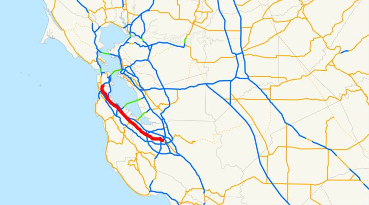 | ||
State Route 82 (SR 82) is a state highway in the U.S. state of California that runs from Interstate 880 (I-880) in San Jose to I-280 in San Francisco following the San Francisco Peninsula. It is the spinal arterial road of the peninsula and runs parallel to the nearby Caltrain line along much of the route. In addition, El Camino passes through many historic downtown neighborhoods such as Burlingame, San Mateo, Redwood City, Menlo Park, Palo Alto, Mountain View, and Sunnyvale, some of the most walkable and transit-oriented neighborhoods in the region.
Contents
- Map of CA 82 California USA
- Route description
- History
- Grand Boulevard Initiative
- Major intersections
- References
Map of CA-82, California, USA
Some portions of the highway are named El Camino Real, which also formed part of the historic El Camino Real mission trail.
Route description
SR 82 starts as The Alameda at I-880 in San Jose. Once it enters Santa Clara, SR 82 bends north-east around Santa Clara University and onto El Camino Real, where it continues for the remainder of its trip up the San Francisco Peninsula, paralleling the Caltrain corridor. SR 82, referred to by local residents almost always as "El Camino," runs through a number of cities on the Peninsula, including Palo Alto (passing by Stanford University), San Carlos, San Mateo, Burlingame, and Millbrae, and it is a central artery of the Peninsula communities through which it passes.
In Daly City, SR 82 becomes Mission Street, connecting with San Francisco's Mission Street, but then quickly flows onto San Jose Avenue, crossing Alemany Boulevard, and terminating at I-280.
SR 82 takes an inland course paralleling US 101. The entire route is at street level with at least four lanes of traffic; no portions of it exist as a freeway, although the route is occasionally a divided highway. The Bayshore Freeway and the I-280 tend to provide faster alternatives than Route 82 even during traffic jams on those freeways.
From 1964 to 1968, SR 82 continued past its current end north on Alemany Boulevard to Bayshore Boulevard in San Francisco (see below).
Prior to 2013, SR 82 continued past its current south end on The Alameda, which continues onto Santa Clara St. Then SR 82 turned south on Montgomery St. (southbound) / Autumn St. (northbound); then it turned east on San Carlos St. It turned south on Market St., which becomes 1st St. and then Monterey Highway. It followed Monterey Highway until it turned east briefly on Blossom Hill Road, where it ended at US 101. This relinquished segment south of I-880 within San Jose is legally no longer a state highway, but the state's Streets and Highways Code mandates that the City of San Jose is still required to maintain "signs directing motorists to the continuation of Route 82" and "ensure the continuity of traffic flow" on this segment. Signs along US 101, I-280, and SR 87 where these relinquished segments intersect still have SR 82 shields.
History
Originally a segment of US 101 (and before that, the historic El Camino Real), rapid growth of the San Francisco Bay Area after World War II, including urbanization of the towns along its path, made it completely inadequate for the needs of traffic. The Bayshore Highway to the east was later upgraded to a freeway in 1937 and was originally built as "Bypass (BYP) US 101". When the Bayshore Highway was upgraded into a freeway, the original US 101 route was transferred to the Bayshore Freeway, and El Camino Real becoming US 101 BYP, but people protested because of their concern of them losing their businesses. Eventually, US 101 BYP was reverted back into US 101 two years later in 1939 and the Bayshore Freeway became US 101 BYP until 1964.
In 1964, US 101 was moved again onto the Bayshore Freeway, and its former alignment on El Camino Real became SR 82. It was defined as two portions: From Route (US) 101 near Ford Road south of San Jose to Route (US) 101 in San Francisco (which today corresponds to the Alemany Maze), and from Route (US) 101 near Alemany Boulevard to Route (SR) 87 (current unconstructed SR 230) in San Francisco. In 1968, the portions from I-280 (at current SR 82) to US 101 and from SR 101 to SR 87 were transferred to I-280. SR 87 was then deleted north of SR 237 in 1980, and is only constructed south of US 101., and SR 82 today is designated as part of El Camino Real.
In 2013, SR 82 was relinquished south of I-880 through San Jose. However, the state's Streets and Highways Code states that the City of San Jose is still required to "ensure the continuity of traffic flow on the relinquished former portion of Route 82" along The Alameda into downtown San Jose, and from there along Monterey Highway to its former terminus at Blossom Hill Road and US 101. The city also has the further option to apply to make this segment a business route.
Grand Boulevard Initiative
The Grand Boulevard Initiative is a partnership of nineteen Bay Area transit agencies and municipalities that operate or manage various portions of the route. Although El Camino Real is ultimately under the stewardship of Caltrans, the organization nevertheless sponsors aesthetic and infrastructural improvements along the corridor and its neighboring parcels in order to revitalize the streetscape and promote density and more walkable and transit-oriented development.
Major intersections
Except where prefixed with a letter, postmiles were measured on the road as it was in 1964, based on its original southern terminus at US 101, and do not necessarily reflect current mileage. R reflects a realignment in the route since then, M indicates a second realignment, L refers an overlap due to a correction or change, and T indicates postmiles classified as temporary (for a full list of prefixes, see the list of postmile definitions). Segments that remain unconstructed or have been relinquished to local control may be omitted. The numbers reset at county lines; the start and end postmiles in each county are given in the county column.