
 | ||
Highway 980 (AR 980, Ark. 980, and Hwy. 980) is a state highway designation for all state maintained airport roads in Arkansas.
Contents
- Map of State Hwy 980 Flippin AR 72634 USA
- Section 1
- Section 2
- Benton County
- Boone County
- Bradley County
- Carroll County
- Cleburne County
- Columbia County
- Conway County
- Cross County
- Drew County
- Fulton County
- Howard County
- Lawrence County
- Madison County
- Marion County
- Polk County
- Van Buren County
- Former routing
- References
Map of State Hwy 980, Flippin, AR 72634, USA
Section 1
Arkansas Highway 980 is a state highway of 2.78 miles (4.47 km) in Arkansas County. It connects Arkansas Highway 130 with Almyra Municipal Airport in Almyra.
Section 2
Arkansas Highway 980 is a state highway of 1.93 miles (3.11 km) in Arkansas County. It connects U.S. Route 165 with De Witt Municipal Airport in south De Witt.
Benton County
Arkansas Highway 980 is a state highway of 0.20 miles (0.32 km) in Benton County. It connects AR 59 with Smith Field in Siloam Springs.
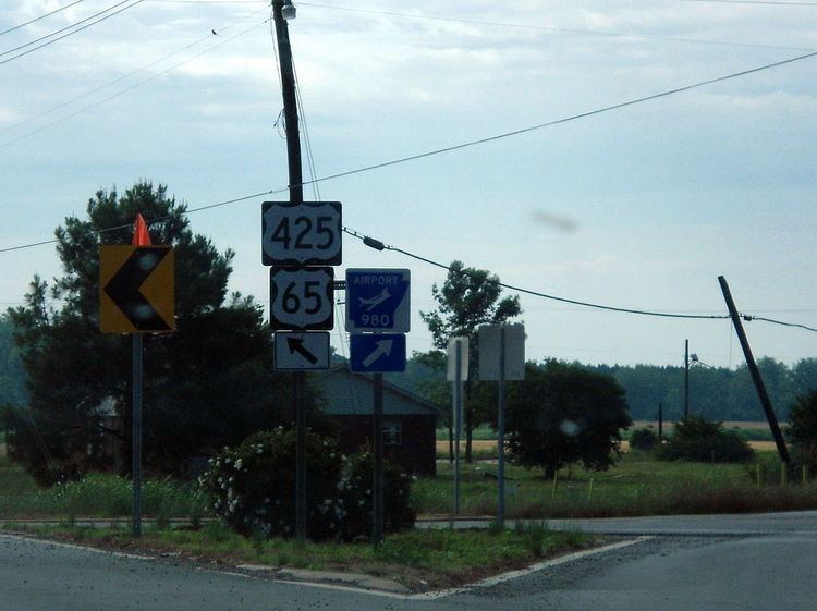
Boone County
Arkansas Highway 980 is a state highway of 0.45 miles (0.72 km) in Boone County. It connects US 62/US 65 with the Boone County Airport in Harrison.
Bradley County
Arkansas Highway 980 is a state highway of 0.52 miles (0.84 km) in Bradley County. It connects US 63/AR 8 with the Warren Municipal Airport south of Warren.
Carroll County
Arkansas Highway 980 is a state highway of 0.60 miles (0.97 km) in Carroll County. It connects US 62 with the Carroll County Airport near Berryville.
Section 1
Arkansas Highway 980 is a state highway of 0.22 miles (0.35 km) in Chicot County. It connects US 165 with the Dermott Municipal Airport near Dermott.
Section 2
Arkansas Highway 980 is a state highway of 1.70 miles (2.74 km) in Chicot County. It connects US 65 with the Lake Village Municipal Airpott Municipal Airport near Lake Village.
Section 1
Arkansas Highway 980 is a state highway of 0.41 miles (0.66 km) in Clay County. It connects US 62/US 67 with the Corning Municipal Airport near Corning.
Section 2
Arkansas Highway 980 is a state highway of 0.31 miles (0.50 km) in Clay County. It connects US 49/AR 1 with the Rector Airport near Rector.
Cleburne County
Arkansas Highway 980 is a state highway of 0.36 miles (0.58 km) in Cleburne County. It connects Arkansas Highway 210 with the Heber Springs Municipal Airport in Heber Springs.
Columbia County
Arkansas Highway 980 is a state highway of 0.66 miles (1.06 km) in Columbia County. The route connects U.S. Route 79 with Magnolia Municipal Airport south of Magnolia.
Conway County
Arkansas Highway 980 is a state highway of 0.73 miles (1.17 km) in Conway County. It connects AR 9 with the Morrilton Airport in Morrilton.
Cross County
Arkansas Highway 980 is a state highway of 1.33 miles (2.14 km) in Cross County. The route connects Arkansas Highway 1 with Wynne Municipal Airport in Wynne.
Section 1
Arkansas Highway 980 is a state highway of 0.82 miles (1.32 km) in Desha County. The route connects Arkansas Highway 4 with McGehee Municipal Airport in McGehee. The route was shortened on January 7, 2009.
Section 2
Arkansas Highway 980 is a state highway of 0.49 miles (0.79 km) in Desha County. The route connects Arkansas Highway 54 with Billy Free Municipal Airport near Dumas.
Drew County
Arkansas Highway 980 is a state highway of 0.50 miles (0.80 km) in Drew County. The route connects U.S. Route 278 with Ellis Field in east Monticello.
Fulton County
Arkansas Highway 980 is a state highway of 0.40 miles (0.64 km) in Fulton County. It connects AR 9 with the Salem Airport in Salem.
Howard County
Arkansas Highway 980 is a state highway of 3.58 miles (5.76 km) in Howard County. The route connects U.S. Route 371 with Howard County Airport north of Nashville.
Lawrence County
Arkansas Highway 980 is a state highway of 1.89 miles (3.04 km) in Lawrence County. It connects US 67 with the Walnut Ridge Regional Airport in College City.
Madison County
Arkansas Highway 980 is a state highway of 1.13 miles (1.82 km) in Madison County. It connects AR 74 with the Huntsville - Madison County Municipal Airport in Huntsville.
Marion County
Arkansas Highway 980 is a state highway of 1.17 miles (1.88 km) in Marion County. It connects AR 178 with the Marion County Regional Airport in Flippin.
Polk County
Arkansas Highway 980 is a state highway of 0.4 miles (0.64 km) in Polk County. It connects Arkansas Highway 8 with the Mena Intermountain Municipal Airport in Mena.
Van Buren County
Arkansas Highway 980 is a state highway of 1.0 mile (1.6 km) in Van Buren County. It connects AR 16 with the Clinton Municipal Airport in Clinton.
Former routing
Arkansas Highway 980 was a state highway of 0.2 miles (0.32 km) in Baxter County. It connected AR 126 with Ozark Regional Airport in Midway. It was removed from the State Highway system on April 27, 2007.