
Airport type Public Elevation AMSL 279 ft / 85 m 6,001 1,829 Phone +1 870-886-5432 | 4/22 6,001 Elevation 85 m Serves Walnut Ridge | |
 | ||
Similar Parachute Inn, Callahan Landing Strip, Walnut Ridge Mayor's O, Hoxie City Hall, Wings of Honor Museum | ||
Boeing 727 airplane dinner walnut ridge regional airport arkansas
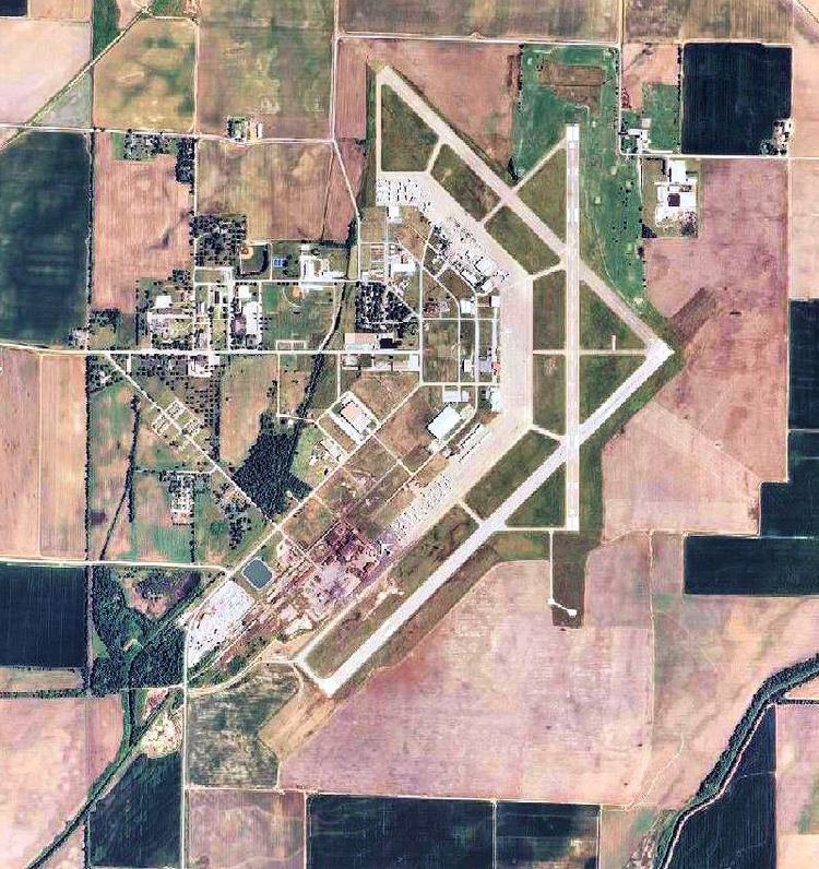
Walnut Ridge Regional Airport (IATA: ARG, ICAO: KARG, FAA LID: ARG) is a city-owned public-use airport located four nautical miles (7 km) northeast of the central business district of Walnut Ridge, a city in Lawrence County, Arkansas, United States. According to the FAA's National Plan of Integrated Airport Systems for 2009–2013, it is categorized as a general aviation facility.
Contents
- Boeing 727 airplane dinner walnut ridge regional airport arkansas
- Wwii era air base walnut ridge regional airport arkansasa former airmy air core training base
- Facilities and aircraft
- References
It is located on land which used to house both Marine Corps Air Facility Walnut Ridge and Walnut Ridge Air Force Station.
Wwii era air base walnut ridge regional airport arkansasa former airmy air core training base
Facilities and aircraft
Walnut Ridge Regional Airport covers an area of 1,800 acres (730 ha) at an elevation of 279 feet (85 m) above mean sea level. It has three runways: 4/22 is 6,001 by 150 feet (1,829 x 46 m) with an asphalt surface; 13/31 is 5,003 by 150 feet (1,525 x 46 m) with a concrete surface; 18/36 is 5,001 by 150 feet (1,524 x 46 m) with a concrete surface.
For the 12-month period ending July 31, 2008, the airport had 94,000 aircraft operations, an average of 257 per day: 97% general aviation, 2% military, and 1% air taxi. At that time there were 55 aircraft based at this airport: 62% single-engine, 9% multi-engine, 27% jet and 2% helicopter.