
Intercommunality Brive Area 39.01 km² Population 3,715 (2008) | Time zone CET (UTC+1) Local time Sunday 1:16 AM | |
 | ||
Weather 2°C, Wind N at 0 km/h, 81% Humidity | ||
Scottisch d allassac corr ze
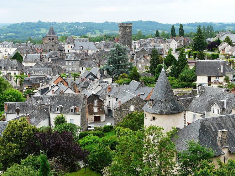
Allassac (Alassac in Occitan) is a French commune in the Corrèze department in the Nouvelle-Aquitaine region of central France.
Contents
- Scottisch d allassac corr ze
- Map of 19240 Allassac France
- Trial ferrer bincaz allassac 7 oct 2016
- Geography
- Hamlets
- Toponymy
- Administration
- Demography
- Economy
- Cinema
- Sports
- Civil heritage
- Religious heritage
- Notable people linked to the commune
- References
Map of 19240 Allassac, France
The inhabitants of the commune are known as Allassacois or Allassacoises
The commune has been awarded three flowers by the National Council of Towns and Villages in Bloom in the Competition of cities and villages in Bloom.
Trial ferrer bincaz allassac 7 oct 2016
Geography
Located in the Brive Basin, the commune of Allassac is irrigated by three major rivers in the north-south direction: the Vézère and its tributaries the Loyre and the Clan which is a sub-tributary of the Corrèze.
Allassac, like many surrounding communes, is part of Vézère Ardoise Country and benefits from the label French Towns and Lands of Art and History.
The town of Allassac is located at the intersection of departmental roads D9, D25, D34 and D134. It is also traversed by the Orléans–Montauban railway line with a station at Allassac. It is located, in orthodromic distances, 6 kilometres east of Objat and 12 kilometres north-west of Brive-la-Gaillarde.
The commune is also served by departmental roads D57, D148, and D901.
Four kilometres to the south-east, the A20 autoroute allows direct access to Allassac through Exit 48.
Hamlets
Apart from the town the commune has the following hamlets:
In Latin aqua saliens meaning "leaping water. The name evokes the rapids and a cascade into a deep gorge. It was called ad illo Salente in 904.
Toponymy
Allassac is derived from the Gallo-Roman word Alaciacus (the estate of Alacius). The first mention in the form Allassac was in the will of Aredius (Saint Yrieix). He called it Alaciaco in 947.
The village is identified as Alassac in the Grand Atlas of the kingdom of France established by Johannes Blaeu in the 17th century then in the Cassini map which represented France between 1756 and 1789. It was then Allassat until the beginning of the French Revolution before the final appearance of the current name in 1801.
The site of La Roche was inhabited as early as the Mesolithic period as evidenced by the Racloirs and Stone tools found in the area.
When it was occupied by the Romans Allassac already had several slate quarries that allowed rapid development of the town.
In 572 Saint Yrieix and his mother donated a farm and forges to Allassac which was part of Yssandon Country. In the Carolingian period there was already a fortified complex with a church and a house belonging to the abbots of Limoges as well as a stately home.
In 864 the relics of the Holy Innocents were transported to Allassac to protect them from Norman invaders.
In the Middle Ages Allassac became a lordship of the Abbey of Saint-Martial of Limoges. This was a co-lordship belonging among others to the Roffignac family who were called the "first Christians of Limousin".
In the 14th century the town had a second enclosure with 17 towers, 8 gates, and 6 castles. The Bishopric fought to protect its territory.
In the 16th and 17th centuries Allassac expanded due to the activities in the slate quarries and food curing despite several sieges. In 1569, Henry d'Anjou spent a few days in the commune with his armies. In 1580 Allassac was the fourth largest city in Lower Limousin (today's Corrèze current). The number of fortified noble houses was increasing.
In 1790, Allassac was briefly the capital of the canton before giving way to Donzenac in 1801.
In 1870 the population was 4,200 inhabitants and for over a century slate mining remained an important industry. The farmers were also slate miners but phylloxera ended this dual economy. The farmers then turned to fruit and tobacco cultivation while developing slate quarries with the new opportunity to ship to Paris by train.
Administration
List of Successive Mayors
(Not all data is known)
Demography
In 2010 the commune had 3,796 inhabitants. The evolution of the number of inhabitants is known through the population censuses conducted in the commune since 1793. From the 21st century, a census of communes with fewer than 10,000 inhabitants is held every five years, unlike larger towns that have a sample survey every year.
Sources : Ldh/EHESS/Cassini until 1962, INSEE database from 1968 (population without double counting and municipal population from 2006)
Economy
Fruit-growing is well-developed in the commune, especially the Limousin apple (AOP), the peach, the plum, and the kiwifruit.
A vineyard called Coteaux du Saillant - Vézère has been replanted on five hectares on schistose soil. Allassac was famous for its vineyards until the end of the 19th century through the Saillant wine cellar. The most common varietals are Chenin, Sauvignon gris, chardonnay, merlot, and cabernet franc.
The breeding of Limousin breed calves raised by their mothers is also a common activity.
Cinema
In 1962 a scene for the film Le Chevalier de Pardaillan by Bernard Borderie was filmed at Pont du Saillant.
Sports
Volleyball: 3 teams are registered in the Union française des œuvres laïques d'éducation physique (UFOLEP) (mixed)
Civil heritage
The commune has a number of buildings and structures that are registered as historical monuments: