
Area rank 136 in Norway Area 804.9 km² Number of airports 1 | Administrative centre Ørsta Demonym(s) Ørsting Population 10,500 (2012) | |
 | ||
Weather 6°C, Wind SW at 3 km/h, 100% Humidity | ||
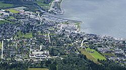
Ørsta is a municipality in Møre og Romsdal county, Norway. It is part of the Sunnmøre region of Western Norway. The administrative centre of the municipality is the village of Ørsta. Other villages in the municipality include Hovdebygda, Flåskjer, Leira, Liadal, Urke, Bjørke, Barstadvik, Åmdalen, Follestaddalen, Nordre Vartdal, Vartdal, Sæbø, Sætre, Store-Standal, and Ytre Standal.
Contents
General information
The municipality of Ørsta was established on 1 August 1883 when it was separated from Volda Municipality. The initial population was 2,070. On 1 January 1893, the Ytrestølen farm (population: 13) was transferred from Ørsta to Volda. On 1 January 1964, the municipalities of Hjørundfjord and Vartdal were also merged with Ørsta. The new, larger municipality of Ørsta had a population of 9,252.
Name
The municipality is named after the Ørstafjorden (Old Norse: Œrstr). The meaning of the name is unknown. Before 1918, the name was written Ørsten.
Coat-of-arms
The coat-of-arms is from modern times. They were granted on 13 July 1984. The arms consist of three silver diamonds on a blue background. The three diamonds represent the mountains reflecting in the waters of the fjord.
Churches
The Church of Norway has four parishes (sokn) within the municipality of Ørsta. It is part of the Søre Sunnmøre deanery in the Diocese of Møre.
Geography
Of the total area, 48% (386 square kilometres or 149 square miles) of the municipality is at an altitude of 600 metres (2,000 ft) or more above sea level. Apart from the mountains, Ørsta's dominant geographical feature is fjords: Storfjorden in the north, Vartdalsfjorden, Ørstafjorden in the west, and Hjørundfjorden in the east. Only in the south is it connected by land to neighbouring Volda Municipality. Otherwise, it borders the municipalities of Sula in the north, Hareid and Ulstein (by sea only) in the west, Sykkylven to the northeast, Stranda to the southeast and Sogn og Fjordane county to the south-southeast.
The municipality is also the heartland of the Sunnmørsalpene mountains, a particularly rugged and wild area of mountains in the southern part of Møre og Romsdal county. Prolific peaks include Slogen at 1,564 metres (5,131 ft), Skårasalen at 1,542 metres (5,059 ft), Kolåstinden at 1,432 metres (4,698 ft), Ramoen at 1,419 metres (4,656 ft), Saudehornet at 1,303 metres (4,275 ft), and Romedalstinden at 1,295 metres (4,249 ft). Other mountains include Hornindalsrokken, Kvitegga, and Jakta.
Economy
Important sectors are mechanical industry and furniture manufacturing, agriculture, commercial fishing, and aquaculture. The first two are predominant in the village of Ørsta while agriculture dominates in adjacent valleys like the Follestaddalen, Åmdalen, and Bondalen valleys. On the other hand, the northern part of the municipality has strong maritime traditions, with Vartdal being the home of one of the largest factory trawler fleets in Norway.
Transportation
These include Ørsta-Volda Airport, Hovden at Hovdebygda which is the regional airport for people living in the municipalities Ørsta, Volda, Vanylven, Sande, Ulstein, Hareid and Herøy, and European Route E39 which transects the municipality in a north–south direction. Ørsta is linked to Sula and Sykkylven by ferry on its northernmost extreme Festøy. It is also linked to Ulstein Municipality by the Eiksund Tunnel, an undersea tunnel that opened on 23 February 2008 that is, currently, the world's deepest at 287 metres (942 ft) below the sea surface.