Elevation 183 ft (56 m) | ||
 | ||
Similar | ||
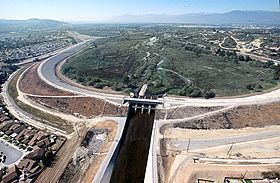
The Whittier Narrows is a water gap between the Puente Hills to the east and the Montebello Hills to the west. The gap is located at the southern boundary of the San Gabriel Valley, through which the Rio Hondo and the San Gabriel River flow through to enter the Los Angeles Basin. The gap is also traversed by both Interstate 605 and California State Route 19.
Contents
- Map of Whittier Narrows California 90601 USA
- Socal whittier narrows earthquakes 1987
- History
- Whittier Narrows Recreation Area
- Whittier Narrows Dam
- References
Map of Whittier Narrows, California 90601, USA
Socal whittier narrows earthquakes 1987
History
The first European land exploration of Alta California, the Spanish Portolà expedition, discovered Whittier Narrows on its return journey to San Diego. On the outbound journey, the party had followed San Jose Creek, reaching the San Gabriel River north of the Narrows. Franciscan missionary Juan Crespi noted in his diary, "We started out in the morning through the gap of the valley of San Miguel [now San Gabriel], which is very full of trees. We traveled a long while to the southwest on the edge of the stream, which, rising from a copious spring of water in the same gap, merits now the name of river; its plain is covered with willows and some slender cotton woods."
On 1 October 1987, the 5.9 Mw Whittier Narrows earthquake affected the Greater Los Angeles Area with a maximum Mercalli intensity of VIII (Severe).
Whittier Narrows Recreation Area
The Whittier Narrows Recreation Area is a large multi-use facility, headquartered in South El Monte, containing North Lake, Center Lake, and Legg Lake (where radio-controlled model speedboats may be operated), a rifle and pistol shooting range, numerous softball and soccer fields with picnic tables, a paved airstrip for radio-controlled hobby aircraft, and a connector trail between the Class I Rio Hondo bicycle path and the San Gabriel River bicycle path. The park is roughly bordered by Garvey Avenue and San Gabriel Blvd to the north and west and Durfee Avenue and Santa Anita/Merced Avenues to the south and east. A convenient point of access is the Rosemead Blvd (State Route 19) exit south from the Pomona (60) Freeway.
Within the Recreation Area is the Whittier Narrows Nature Center, which contains exhibits about the plants and animals of the river environment, including live displays. The center offers public programs, lectures, ranger tours and education programs. In October 2008, a proposed new interpretive center drew controversy over the potential destruction of a large amount of existing wildlife habitat.
Whittier Narrows Dam
The Whittier Narrows Dam is a flood control and water conservation project constructed and operated by the U.S. Army Corps of Engineers, Los Angeles District. It collects runoff from the uncontrolled drainage areas upstream along with releases from the Santa Fe Dam, and can redirect flows into the Rio Hondo or the downstream San Gabriel. It was completed in 1957.
