
OS grid reference TF680016 Post town KING'S LYNN Area 8.59 km² Postcode district PE33 | Sovereign state United Kingdom Dialling code 01366 Population 660 (2011 census) | |
 | ||
District King's Lynn and West Norfolk | ||
Wereham is a small village and civil parish in the English county of Norfolk.
Contents
Map of Wereham, UK
Location
Wereham lies in the Wissey valley and is on the main A134 road; it is some five miles to the east of the town of Downham Market and thirteen miles from King's Lynn. Neighbouring villages include Boughton, Fincham, Crimplesham, West Dereham, Wretton and Stoke Ferry.
History
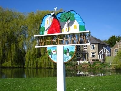
In the centre of the village is the pond - known locally as the pit. Nearby on the village green, the Village sign depicts 'Billy the Seal', one of Wereham's most famous residents from the 1920s.
Facilities
Wereham once had four pubs: the George and Dragon, The Crown, The Nags Head and The Chequers; however, only the George and Dragon remains. The village also had a school; this closed in the 1980s.
The Parish Church, dedicated to St Margaret of Antioch, is in the centre of the village.