
 | ||
Map review of reute in upper swabia for farming simulator 15
Upper Swabia (German: Oberschwaben or Schwäbisches Oberland) is a region in Germany in the federal states of Baden-Württemberg and Bavaria. The name refers to the area between the Swabian Jura, Lake Constance and the Lech. Its counterpart is Lower Swabia (Niederschwaben), the region around Heilbronn.
Contents
- Map review of reute in upper swabia for farming simulator 15
- Geography
- Administration
- History
- Theme routes
- Vantage points
- Print media
- Radio and television
- Railways
- Roads
- Airports
- References
Geography
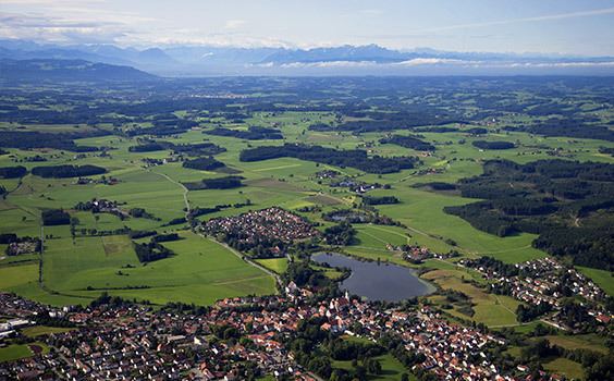
The region of Upper Swabia is situated in the central south of Germany consisting of the south-east of Baden-Württemberg and the south-west bavarian Swabia region and lies on the Iller-Lech Plateau, also known as the Upper Swabian Plain, one of the natural regions of Germany. The landscape of Upper Swabia was formed by retreating glaciers after the Riss glaciation, leaving behind a large number of shallows which quickly filled up with water. This led to the large quantity of lakes in Upper Swabia. The landscape of Upper Swabia is quite hilly rising from approximately 458 metres above sea level in the valley of the river Danube to a maximum of 833 metres above sea level in the south-west of Upper Swabia only to drop again to 395 meters above sea level at Lake Constance. The European watershed also passes through the region, with some rivers emptying into the river Danube (ultimately flowing into the Black Sea) and others emptying into Lake Constance (ultimately ending in the North Sea).
Due to Upper Swabia's altitude and hilly terrain, agriculture consists mainly of dairy farming, the exception being the basin of the river Schussen, where the predominant produce is hops and fruits.
Upper Swabia is still a very rural area dominated by villages. The urban population is concentrated in the cities of Friedrichshafen, Ravensburg & Weingarten and Biberach an der Riß as well as Memmingen and Günzburg.
The eastern border of Upper Swabia has been disputed for some time. Historically, the river Lech marks the border between Swabia and Bavaria. However, this would mean that large parts of Bavarian Swabia would have to be incorporated into Upper Swabia. As a result, these days the river Iller marks the eastern border of Upper Swabia.
The inhabitants of the former Free Imperial City Ulm and those that belonged to the former Imperial Abbey of Zwiefalten do not consider themselves as being part of Upper Swabia. Yet, in spite of their location close to the Swabian Alb, geographically, historically and culturally, they have always been closely connected to Upper Swabia.
Administration
Upper Swabia is part of the Regierungsbezirk Tübingen, a Regierungsbezirk being a sub-division of a federal state.
The following districts are wholly or partially part of Upper Swabia:
History
Upper Swabia has been populated at least since the Neolithic age. Archaeological evidence confirming this was discovered around the Federsee, a lake near Bad Buchau. Until around the year 260 CE, the region that was to become Upper Swabia, was part of the Roman province of Raetia, after which the Alamanni invaded the Agri Decumates and settling there.
During the Merovingian period, Upper Swabia came under the rule of the Frankish kings. It was part of the Duchy of the Alamanni. During the same period, the Christianization of the region began.
During the Carolingian, Ottonian and Salian period, Upper Swabia was part of the Duchy of Swabia.
From the High Middle Ages onwards, Upper Swabia became fragmented into a large number of small independent political units: Free Imperial Cities, principalities, counties, seigneuries, Imperial Abbeys and other clerical territories.
During the German Peasants' War of 1524 - 1525, Upper Swabia was a centre of the revolt. The peasants formed three armed groups, called Haufen (or Haufe): the Allgäuer Haufen, active in the Allgäu and eastern Upper Swabia, the Seehaufen, centred on the region north of Lake Constance, and the Baltringer Haufen, named after the village of Baltringen, a few kilometres south of Laupheim in northern Upper Swabia.
During the revolt, numerous castles and monasteries in Upper Swabia were destroyed by the peasants. By July 1525, however, the rising had been utterly suppressed in Upper Swabia, with countless peasants losing their lives either due to battles or due to punitive measures inflicted upon them afterwards by their lords. Economically and socially, the consequences were dramatic: whole communities were bankrupt and unable to pay proper taxes for a long time, the legal position of peasants was not to be altered for another 300 years, and due to the large number of outlawed peasants trying to survive by illegal means, such as robbery, commerce was severely hindered.
This instability was one of the factors that lead to Upper Swabia's becoming a plaything of marauding armies during the Thirty Years War 1618 - 1648. Military actions followed by disease, such as the plague, led to a severe depopulation of Upper Swabia.
After the end of the war, the Catholic Church intensified its efforts to regain ground from the Protestants. These efforts are known as the Counter-Reformation. The local lords, secular and clerical, tried to attract immigrants to areas affected by the ravages of war and to re-populate these areas. This led to an economic upturn within the region. The efforts of the Counter-Reformation and the newly acquired financial ability of both secular and clerical lords enabled them to restore, extend and enhance the already existing seigneurial buildings in Baroque-style. The result of this is today called Upper Swabian Baroque.
During the secularization and mediatization in 1803, almost all monasteries were dissolved and the Free Imperial Cities lost their independence. With the end of the Holy Roman Empire in 1806, marked by the Reichsdeputationshauptschluss, catholic Upper Swabia was incorporated into the protestant Kingdom of Württemberg. This annexation was finalized during the Congress of Vienna in 1815.
The aristocratic dynasties that ruled Upper Swabia for centuries still have considerable political and economic influence and power. After World War I and the end of the Kingdom of Württemberg, Upper Swabia became part of the new federal state Württemberg.
After World War II, the northernmost areas of Upper Swabia became part of the American occupation zone, while the larger, southern area became part of the French occupation zone. In 1946, the Allied authorities founded the states of Württemberg-Baden and Württemberg-Hohenzollern, the borders of which ran along the borders of the occupation zones. As a consequence, the northern areas of Upper Swabia became part of the state of Württemberg-Baden and the southern areas became part of the state of Württemberg-Hohenzollern. Both states joined the Federal Republic of Germany on its founding in 1949. This situation lasted until 1952, when, following a referendum the previous year, Württemberg-Baden and Württemberg-Hohenzollern together with Baden created the new federal state of Baden-Württemberg.
Theme routes
Vantage points
In spite of this, the touristic development of Upper Swabia has been rather slow during the last decennia. The bordering regions of Allgäu, Swabian Alb, Black Forest and particularly the area around Lake Constance have been more prosperous. Even politicians remarked in the 1990s that Upper Swabia was more an industrial region, albeit only in a few centres, than a tourist destination. However, during recent years, amends have been made in order to attract more tourist. This has been supported by the state government which provided subsidies, particularly to improve rural infrastructure.
Print media
Radio and television
Railways
Upper Swabia is criss-crossed by several railway lines:
Roads
There are no motorways (Autobahn) in Upper Swabia. However, several federal highways (Bundesstraße) traverse the region: