
Existed: 1926 – present Length 358.7 km | SR 4 SR 5 → Constructed 1926 | |
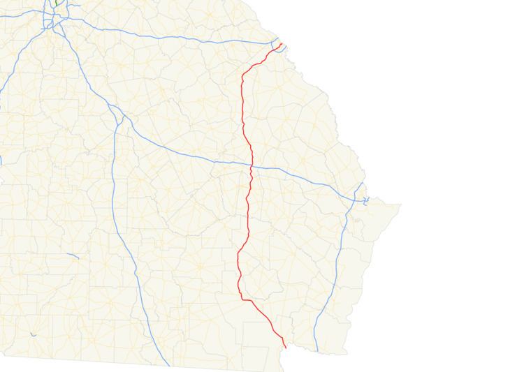 | ||
South end: US 1 / US 23 / US 301 / SR 15 and SR 4 / SR 15 at the Florida state line northwest of Hilliard, FL | ||
U.S. Route 1 (US 1) in the U.S. state of Georgia, which is concurrent for almost its entire length with State Route 4 (SR 4), is a highway that travels south-to-north through portions of Charlton, Ware, Bacon, Appling, Toombs, Emanuel, Jefferson, and Richmond counties in the southeastern part of the U.S. state of Georgia. In Georgia, the highway begins at US 1/US 23/US 301/SR 15 at the St. Marys River and the Florida state line, where SR 4 and SR 15 ends. It travels to its northern terminus at US 1/US 25/US 78/US 278/SC 121 at the Savannah River and the South Carolina state line in Augusta. Here both SR 10 and SR 121 end as well.
Contents
Route description
The route starts at the Florida state line on the St. Marys River in eastern Charlton County, and initially travels to the north-northwest as a four-lane highway through Folkston, concurrent with US 23, US 301, and SR 15. In Homeland, US 301 splits off and travels in a northerly direction, while US 1 turns to the northwest, crosses into Ware County, and initially forms the Ware–Brantley county line. The highway continues northwest and travels west through Waycross. For the majority of its length in Charlton and Ware counties to Waycross the route is very closely paralleled by the CSX rail line from Georgia into Florida. In Waycross, US 1 turns north to cross into Bacon County and Alma. In northern Bacon County, US 23 splits off to the northwest, while US 1 continues in a northeasterly direction, and crosses into Appling County.
Heading through Baxley, the highway continues north, and crosses the Altamaha River into Toombs County, then heads through Lyons, and on into Emanuel County. US 1 becomes a four-lane grassy-median-divided highway just before crossing I-16 north of Oak Park, and continues north to Swainsboro. Still heading north, the route crosses into Jefferson County and travels through Wadley and Louisville, where it becomes concurrent with US 221 on its way to Wrens.
From Wrens, having split from US 221, US 1 turns northeast and crosses into Richmond County, cutting through the southern portion of Fort Gordon, before reaching the metropolitan area of Augusta, crossing I-520, and heading into central Augusta. There, US 1 and SR 4 separate. SR 4 takes the older route to cross the Savannah River, eventually traveling concurrent with US 25 Business, while US 1 turns northeast with US 78, and US 278 on Gordon Highway, which soon turn north. US 25 joins the concurrency. They then cross the Savannah River into South Carolina.
History
In 1920, the designation of SR 4 was used for a route in northwestern Georgia, traveling from the Alabama state line east via Rome to Cartersville, where it met SR 3. This highway is signed today as SR 20 and SR 100 to Rome, and US 411 and SR 20 from Rome to Cartersville. The current route from Folkston to Alma was signed as SR 15, and the portion to Baxley had no state route designation at the time. Also, the current path north from Baxley through Lyons to Swainsboro does not appear on 1920 maps at all; instead, an unsigned route is shown from Lyons to Reidsville, and on to Metter. From Swainboro, the current route was signed at the time as SR 17 to Louisville, and another unsigned route continued to Augusta
By 1926, SR 4 was still located in northwest Georgia in various states of surface condition, from hard surface around Rome to unimproved on some portions, but had been extended from Cartersville north to Fairmount; this stretch of the route is signed today as US 411 and SR 61. The current route in the southeast, which was already signed as US 1, featured semi-hard surface to Waycross, and was in various stages of improvement from Waycross to Baxley. The current section from Baxley to Swainsboro, which had not existed in 1920, appeared as an unimproved road, signed as SR 32, by 1926. From Swainsboro to Augusta, the route again appeared in various stages of improvement, now concurrent with SR 17 to Wrens, and as SR 24 from Louisville to Augusta.
By 1929, the current designations of US 1 and SR 4 in the southeast of Georgia were found on Georgia highway maps. By early 1932, the entirety of the current route appears to have been covered by hard surface, which makes this route an exception, rather than a rule, of the common surface conditions at the time.
SR 4 as a standalone highway
SR 4 splits off from US 1 when that highway intersects US 78/US 278/SR 10 (Gordon Highway) in the central part of Augusta. From that intersection, SR 4 travels to the northeast on Deans Bridge Road. At an intersection with Milledgeville Road, it takes on that name. It intersects the northern terminus of 15th Avenue and the western terminus of Martin Luther King Jr. Boulevard just north of Southview Cemetery. It turns to the northeast on 15th Street, which is also known as the Ruth B. Crawford Highway. It passes the T. W. Josey High School and then has a partial interchange with Poplar Street and Wrightsboro Road. It then travels on the Rosa T. Beard Memorial Bridge, which crosses over both roadways. Here, it begins to travel along the southeastern edge of the Medical District of the city. Just after intersecting the eastern terminus of Central Avenue, it travels between Paine College and the Medical College of Georgia. At an intersection with Laney Walker Boulevard, it leaves Paine College and enters the Medical District proper. It passes the Augusta University Medical Center and then the VA Medical Center. On the northern edge of this hospital, it intersects Walton Way. At this intersection, SR 4 turns right and travels on Walton Way. It passes the Augusta University Annex building. At an intersection with 13th Street, SR 4 turns left and immediately crosses over the Augusta Canal. After it leaves the Medical District, it crosses over some railroad tracks of CSX. It then passes the John S. Davidson Fine Arts Magnet School. After traveling under a bridge that carries SR 28 (John C. Calhoun Expressway), it intersects US 25 Bus. (Broad Street). The two highways begin a concurrency to the north-northeast. Just after intersecting the eastern terminus of SR 104 (Jones and Reynolds streets on one way streets, they cross over the Savannah River on the James U. Jackson Memorial Bridge. Here, SR 4 ends, and US 25 Bus. enters North Augusta, South Carolina.
The entire route is in Augusta, Richmond County.
Waycross
U.S. Route 1 Business (US 1 Bus.) is a 9.622-mile-long (15.485 km) business route of US 1 partially in the city limits of Waycross. It is concurrent with US 23 Bus. and SR 4 Bus. for its entire length.
US 1 Bus./US 23 Bus./SR 4 Bus. travels northwest into the heart of Waycross, while the main route of US 1/US 23/SR 4 heads west across the southern portion of the city. US 1 Bus./US 23 Bus./SR 4 Bus. begins at an intersection with the U 1/US 23/SR 4 mainline (which also use the Memorial Drive name), as well as US 82/SR 520 (Brunswick Highway) in the southwestern part of the city. They travel to the west-northwest on Memorial Drive and cross over the city drainage canal before an intersection with US 84/SR 38 (Plant Avenue Extension). The three highways turn northeast and travel concurrent with US 84/SR 38 for approximately 1,000 feet (300 m). US 1 Bus./US 23 Bus./SR 4 Bus. then turns to the northwest, onto Ossie Davis Parkway. They curve to the north-northwest and pass Wacona Elementary School. They cross over Kettle Creek and curve to the northwest. They pass the Waycross–Ware County Airport, the Ware State Prison, and Ware County Jail. They continue to the northwest and then reach their northern terminus, a second intersection with the US 1/US 23/SR 4 mainline.
US 1 Bus. was established in 1994, replacing the old mainline US 1 through Waycross, via Memorial Drive, Plant Avenue, State Street, and Alma Highway.
The entire route is in Ware County.
Alma
State Route 4 Alternate (SR 4 Alt.) is a 1.613-mile-long (2.596 km) alternate route of SR 4 in Alma travels south-to-north through the western part of the city, crossing SR 32, while the main route of US 1/US 23/SR 4 heads through the heart of downtown, past the Alma campus of Okefenokee Technical College. It is the only special route of SR 4 that is not concurrent with a special route of US 1.
The entire route is in Alma, Bacon County.
Swainsboro
U.S. Route 1 Business (US 1 Bus.) is a 7.876-mile-long (12.675 km) business route of US 1 that is partially within the city limits of Swainsboro. It is concurrent with SR 4 Bus. for its entire length. US 1 Bus./SR 4 Bus. begins at an intersection with US 1/SR 4/SR 57 (South Main Street) south of Swainsboro. It travels to the north-northeast and immediately curves to the north-northwest. Just before an intersection with both the eastern terminus of Mixon Road and the western terminus of Quick Road, the highway curves back to the north-northeast. Just after entering the city, it passes Swainsboro High School. After beginning to curve to the northwest, it skirts along the northeastern edge of Harmon Park. In downtown is an intersection with US 80/SR 26/SR 56 (Main Street). US 1 Bus./SR 4 Bus. continue to the northwest and leave the city limits of Swainsboro. It curves to the west-northwest just before reaching the northern terminus of both highways, another intersection with the US 1/SR 4 mainline.
The entire route is in Emanuel County.
Wadley
U.S. Route 1 Business (US 1 Bus.) is a 3.645-mile-long (5.866 km) business route of US 1 that is mostly within the city limits of Wadley. It travels north through the heart of downtown, crossing US 319/SR 78, while the main route of US 1/SR 4 heads through the east part of the city. US 1 Bus. was established in 1981, replacing the old mainline US 1 through Wadley, via Main Street.
The entire route is in Jefferson County.
Louisville
U.S. Route 1 Business (US 1 Bus.) is a 2.900-mile-long (4.667 km) business route of US 1 completely within the city limits of Louisville. It is concurrent with SR 4 for its entire length. US 1 Bus./SR 4 Bus. begins at an intersection with the US 1/SR 4 mainline (Jefferson Davis Highway) in the southeastern part of the city. This intersection is just west of the Louisville Municipal Airport. The two highways travel to the northwest on Broad Street and cross over Savannah Branch. They pass the Louisville Public Library and then intersect US 221/SR 24 (Peachtree Street). The four highway travel concurrently to the northeast. At West 9th Street, SR 24 splits off, and then the other three highways curve to the north-northeast. They pass the Jefferson Hospital and curve back to the northeast before intersecting US 1/SR 4/SR 17 in the northern part of the city. Here, US 1 Bus. and SR 4 Bus. end, while US 221 joins the mainline concurrency.
US 1 Bus. was established in 1981, replacing the old mainline US 1 through Louisville, via Broad Street and Peachtree Street.
The entire route is in Louisville, Jefferson County.